Estimated Value: $665,000 - $782,000
3
Beds
3
Baths
1,602
Sq Ft
$464/Sq Ft
Est. Value
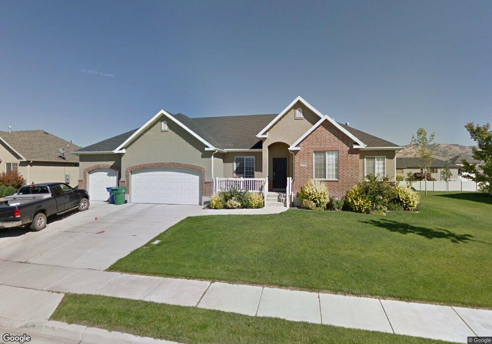
About This Home
This home is located at 2394 W 1350 N, Lehi, UT 84043 and is currently estimated at $742,749, approximately $463 per square foot. 2394 W 1350 N is a home located in Utah County with nearby schools including North Point Elementary School, Willowcreek Middle School, and Lehi High School.
Ownership History
Date
Name
Owned For
Owner Type
Purchase Details
Closed on
Jun 7, 2006
Sold by
Envision Development Llc
Bought by
Sorenson Nathan H and Sorenson Tiffany
Current Estimated Value
Home Financials for this Owner
Home Financials are based on the most recent Mortgage that was taken out on this home.
Original Mortgage
$201,000
Outstanding Balance
$118,039
Interest Rate
6.55%
Mortgage Type
New Conventional
Estimated Equity
$624,710
Purchase Details
Closed on
Nov 23, 2005
Sold by
Sunrise Ridge At Springville Llc
Bought by
Envision Development Llc
Home Financials for this Owner
Home Financials are based on the most recent Mortgage that was taken out on this home.
Original Mortgage
$606,060
Interest Rate
5.97%
Mortgage Type
Construction
Create a Home Valuation Report for This Property
The Home Valuation Report is an in-depth analysis detailing your home's value as well as a comparison with similar homes in the area
Home Values in the Area
Average Home Value in this Area
Purchase History
| Date | Buyer | Sale Price | Title Company |
|---|---|---|---|
| Sorenson Nathan H | -- | Title West Title Company | |
| Envision Development Llc | -- | Title West Title Company |
Source: Public Records
Mortgage History
| Date | Status | Borrower | Loan Amount |
|---|---|---|---|
| Open | Sorenson Nathan H | $201,000 | |
| Previous Owner | Envision Development Llc | $606,060 |
Source: Public Records
Tax History Compared to Growth
Tax History
| Year | Tax Paid | Tax Assessment Tax Assessment Total Assessment is a certain percentage of the fair market value that is determined by local assessors to be the total taxable value of land and additions on the property. | Land | Improvement |
|---|---|---|---|---|
| 2025 | $3,032 | $735,800 | $300,300 | $435,500 |
| 2024 | $3,032 | $354,860 | $0 | $0 |
| 2023 | $2,783 | $353,595 | $0 | $0 |
| 2022 | $3,000 | $369,600 | $0 | $0 |
| 2021 | $2,657 | $494,800 | $173,800 | $321,000 |
| 2020 | $2,504 | $460,900 | $160,900 | $300,000 |
| 2019 | $2,218 | $424,500 | $160,900 | $263,600 |
| 2018 | $2,103 | $380,500 | $138,000 | $242,500 |
| 2017 | $2,114 | $203,335 | $0 | $0 |
| 2016 | $2,055 | $183,425 | $0 | $0 |
| 2015 | $1,982 | $167,915 | $0 | $0 |
| 2014 | $1,842 | $155,155 | $0 | $0 |
Source: Public Records
Map
Nearby Homes
- 1302 N 2450 W
- 1165 N 2550 W
- 1185 N 2650 W
- Yalecrest Plan at Riverwalk
- Trio Plan at Riverwalk
- Timpani Plan at Riverwalk
- Tenor Plan at Riverwalk
- Prelude Plan at Riverwalk
- Princeton Plan at Riverwalk
- Octave Plan at Riverwalk
- Madrigal Plan at Riverwalk
- Interlude Plan at Riverwalk
- Harvard Plan at Riverwalk
- Harrison Plan at Riverwalk
- Fortissimo Plan at Riverwalk
- Browning Plan at Riverwalk
- Forte Plan at Riverwalk
- Canon Plan at Riverwalk
- Finale Plan at Riverwalk
- Bravo Plan at Riverwalk