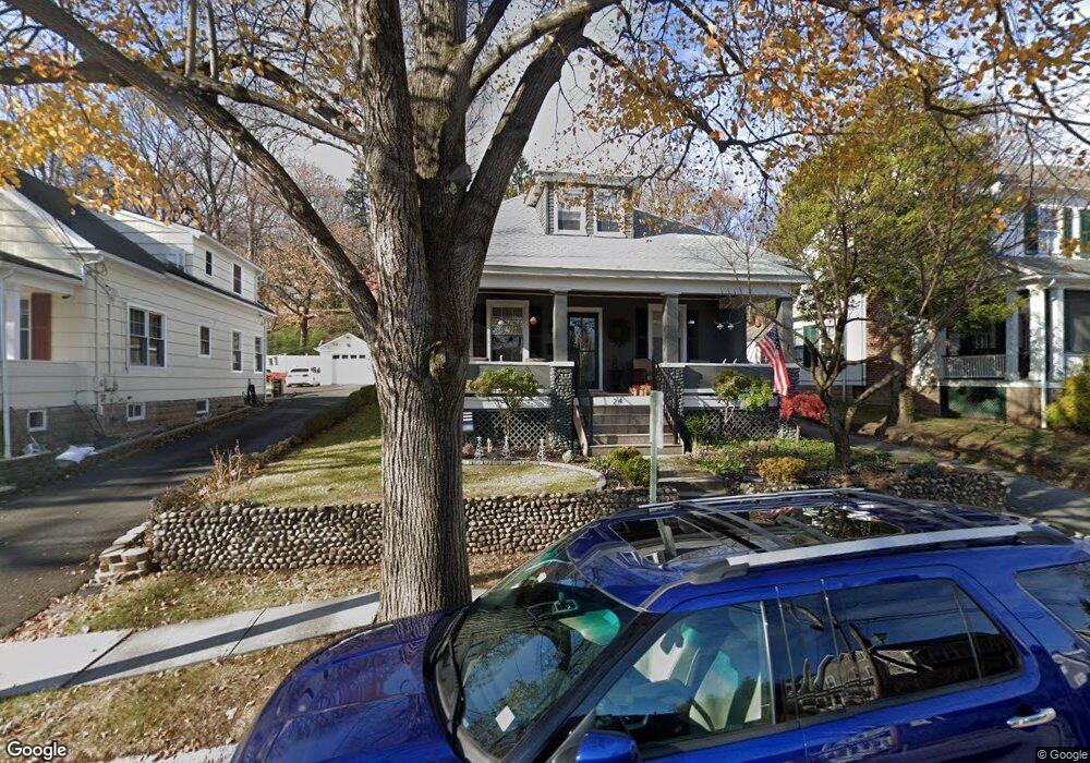
24 Colonial Rd Morristown, NJ 07960
Estimated Value: $707,000 - $960,000
--
Bed
--
Bath
1,960
Sq Ft
$415/Sq Ft
Est. Value
About This Home
This home is located at 24 Colonial Rd, Morristown, NJ 07960 and is currently estimated at $813,010, approximately $414 per square foot. 24 Colonial Rd is a home located in Morris County with nearby schools including Hillcrest School, Thomas Jefferson School, and Alexander Hamilton School.
Ownership History
Date
Name
Owned For
Owner Type
Purchase Details
Closed on
Feb 23, 2005
Sold by
Slavin Samuel
Bought by
Patrick Christel and Christel Suzanne
Current Estimated Value
Home Financials for this Owner
Home Financials are based on the most recent Mortgage that was taken out on this home.
Original Mortgage
$332,000
Outstanding Balance
$163,393
Interest Rate
5.37%
Mortgage Type
Adjustable Rate Mortgage/ARM
Estimated Equity
$649,617
Create a Home Valuation Report for This Property
The Home Valuation Report is an in-depth analysis detailing your home's value as well as a comparison with similar homes in the area
Home Values in the Area
Average Home Value in this Area
Purchase History
| Date | Buyer | Sale Price | Title Company |
|---|---|---|---|
| Patrick Christel | $415,000 | -- |
Source: Public Records
Mortgage History
| Date | Status | Borrower | Loan Amount |
|---|---|---|---|
| Open | Patrick Christel | $332,000 |
Source: Public Records
Tax History Compared to Growth
Tax History
| Year | Tax Paid | Tax Assessment Tax Assessment Total Assessment is a certain percentage of the fair market value that is determined by local assessors to be the total taxable value of land and additions on the property. | Land | Improvement |
|---|---|---|---|---|
| 2025 | $9,168 | $582,100 | $332,200 | $249,900 |
| 2024 | $10,470 | $582,100 | $332,200 | $249,900 |
| 2023 | $10,470 | $360,300 | $225,200 | $135,100 |
| 2022 | $10,348 | $360,300 | $225,200 | $135,100 |
| 2021 | $10,348 | $360,300 | $225,200 | $135,100 |
| 2020 | $10,387 | $360,300 | $225,200 | $135,100 |
| 2019 | $10,384 | $360,300 | $225,200 | $135,100 |
| 2018 | $10,251 | $360,300 | $225,200 | $135,100 |
| 2017 | $9,944 | $360,300 | $225,200 | $135,100 |
| 2016 | $9,688 | $360,300 | $225,200 | $135,100 |
| 2015 | $9,458 | $360,300 | $225,200 | $135,100 |
| 2014 | $9,353 | $360,300 | $225,200 | $135,100 |
Source: Public Records
Map
Nearby Homes
- 8 Mendham Ave
- 25 Phoenix Ave
- 61 Western Ave Unit C
- 480 Sussex Place
- 80 Western Ave
- 39 Clinton Place
- 86 Chestnut St
- 60 Chestnut St Unit 2
- 58 Chestnut St Unit 1
- 7 Prospect St Unit 705
- 16 Dellwood Ave
- 40 Park - Unit 315 Unit 315
- 40 Park502 Unit 502
- 51 Mount Kemble Ave Unit 405
- 1 Jardine Ct
- 1 Twin Oaks Ln
- 11 Hazel St Unit 1-2
- 18 Hillairy Ave
- 48 Miller Rd Unit 50
- 9 Dorothy Dr