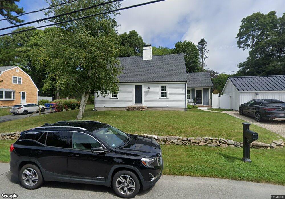
24 Driscoll Ln Mattapoisett, MA 02739
Estimated Value: $665,000 - $753,000
3
Beds
2
Baths
1,937
Sq Ft
$363/Sq Ft
Est. Value
About This Home
This home is located at 24 Driscoll Ln, Mattapoisett, MA 02739 and is currently estimated at $703,526, approximately $363 per square foot. 24 Driscoll Ln is a home located in Plymouth County with nearby schools including Center School, Old Hammondtown Elementary, and Old Rochester Regional High School.
Ownership History
Date
Name
Owned For
Owner Type
Purchase Details
Closed on
Jun 25, 2012
Sold by
Antin Katherine C and Connelly Katherine C
Bought by
Connelly Katherine C and Connelly Brian M
Current Estimated Value
Home Financials for this Owner
Home Financials are based on the most recent Mortgage that was taken out on this home.
Original Mortgage
$399,845
Outstanding Balance
$281,536
Interest Rate
4.25%
Mortgage Type
FHA
Estimated Equity
$421,990
Purchase Details
Closed on
Aug 15, 2003
Sold by
Bennett Warren and Bennett Louise
Bought by
Connelly Brian M and Antin Katherine C
Create a Home Valuation Report for This Property
The Home Valuation Report is an in-depth analysis detailing your home's value as well as a comparison with similar homes in the area
Home Values in the Area
Average Home Value in this Area
Purchase History
| Date | Buyer | Sale Price | Title Company |
|---|---|---|---|
| Connelly Katherine C | -- | -- | |
| Connelly Katherine C | -- | -- | |
| Connelly Katherine C | -- | -- | |
| Connelly Brian M | $377,500 | -- | |
| Connelly Brian M | $377,500 | -- |
Source: Public Records
Mortgage History
| Date | Status | Borrower | Loan Amount |
|---|---|---|---|
| Open | Connelly Katherine C | $399,845 | |
| Closed | Connelly Katherine C | $399,845 |
Source: Public Records
Tax History Compared to Growth
Tax History
| Year | Tax Paid | Tax Assessment Tax Assessment Total Assessment is a certain percentage of the fair market value that is determined by local assessors to be the total taxable value of land and additions on the property. | Land | Improvement |
|---|---|---|---|---|
| 2025 | $6,016 | $559,100 | $164,900 | $394,200 |
| 2024 | $5,921 | $563,400 | $164,900 | $398,500 |
| 2023 | $5,861 | $521,000 | $147,300 | $373,700 |
| 2022 | $5,623 | $453,500 | $122,700 | $330,800 |
| 2021 | $5,277 | $407,200 | $136,400 | $270,800 |
| 2020 | $4,971 | $368,500 | $129,900 | $238,600 |
| 2019 | $4,904 | $371,200 | $129,900 | $241,300 |
| 2018 | $4,657 | $357,700 | $114,900 | $242,800 |
| 2017 | $4,537 | $347,100 | $114,900 | $232,200 |
| 2016 | $4,377 | $331,600 | $120,600 | $211,000 |
| 2015 | $4,237 | $325,900 | $114,900 | $211,000 |
| 2014 | $4,112 | $323,300 | $114,900 | $208,400 |
Source: Public Records
Map
Nearby Homes
- 9 Hitching Post Rd
- 13 Park Place
- 35 North St
- 12 Cannon St
- 7 Pearl St
- 47 Fairhaven Rd
- 8 Captains Ln
- 11 Captains Ln
- 52 Prince Snow Cir
- 19 High Ridge Dr
- 83 Fairhaven Rd
- 15 Ned's Point Rd
- 31 Split Rock Ln
- 0 Whalers Way
- 1 Starboard Way
- 41 Starboard Way
- 3 Brandt Island Rd
- 2 Golf Cottage Way
- 4 Golf Cottage Way
- 3 Rock St