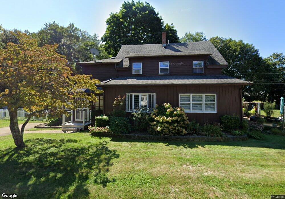
24 Geordan Ave Wrentham, MA 02093
Estimated Value: $627,023 - $747,000
4
Beds
2
Baths
2,243
Sq Ft
$299/Sq Ft
Est. Value
About This Home
This home is located at 24 Geordan Ave, Wrentham, MA 02093 and is currently estimated at $670,006, approximately $298 per square foot. 24 Geordan Ave is a home located in Norfolk County with nearby schools including Delaney Elementary School and Charles E Roderick.
Ownership History
Date
Name
Owned For
Owner Type
Purchase Details
Closed on
Nov 28, 2017
Sold by
Marchioli Mark A
Bought by
Marchioli Mark A and Liebman Kendall
Current Estimated Value
Purchase Details
Closed on
Nov 21, 2011
Sold by
Bergman Richard A and Bergman Josephine A
Bought by
Marchioli Mark A
Home Financials for this Owner
Home Financials are based on the most recent Mortgage that was taken out on this home.
Original Mortgage
$282,648
Interest Rate
4.4%
Mortgage Type
FHA
Create a Home Valuation Report for This Property
The Home Valuation Report is an in-depth analysis detailing your home's value as well as a comparison with similar homes in the area
Purchase History
| Date | Buyer | Sale Price | Title Company |
|---|---|---|---|
| Marchioli Mark A | -- | -- | |
| Marchioli Mark A | $290,000 | -- |
Source: Public Records
Mortgage History
| Date | Status | Borrower | Loan Amount |
|---|---|---|---|
| Previous Owner | Marchioli Mark A | $282,648 |
Source: Public Records
Tax History
| Year | Tax Paid | Tax Assessment Tax Assessment Total Assessment is a certain percentage of the fair market value that is determined by local assessors to be the total taxable value of land and additions on the property. | Land | Improvement |
|---|---|---|---|---|
| 2025 | $6,206 | $535,500 | $269,600 | $265,900 |
| 2024 | $6,337 | $528,100 | $269,600 | $258,500 |
| 2023 | $6,379 | $505,500 | $245,100 | $260,400 |
| 2022 | $5,927 | $433,600 | $228,700 | $204,900 |
| 2021 | $5,817 | $413,400 | $199,600 | $213,800 |
| 2020 | $4,969 | $348,700 | $177,500 | $171,200 |
| 2019 | $4,715 | $333,900 | $162,700 | $171,200 |
| 2018 | $5,219 | $366,500 | $162,700 | $203,800 |
| 2017 | $4,876 | $342,200 | $159,600 | $182,600 |
| 2016 | $4,771 | $334,100 | $154,900 | $179,200 |
| 2015 | $4,594 | $306,700 | $149,000 | $157,700 |
| 2014 | $4,200 | $274,300 | $143,300 | $131,000 |
Source: Public Records
Map
Nearby Homes
- 576 Dedham St
- 11 Weber Farm Rd Unit 11
- 8 Weber Farm Rd Unit 8
- 30 Weber Farm Rd Unit 30
- 9 Sharon Ave
- 11 Sharon Ave
- 25 Foxboro Rd
- 0 W Birch Rd
- 246 Forest Grove Ave
- 10 Nature View Dr
- 15 Nature View Dr
- 75 Foxboro Rd
- 7 Hill St Unit 12
- 7 Hill St Unit 16
- 65 Foxboro Rd
- 8 Ridgefield Rd
- 131 Washington St Unit 42
- 131 Washington St Unit 50
- 8 Conway Ln
- 500 Franklin St
Your Personal Tour Guide
Ask me questions while you tour the home.