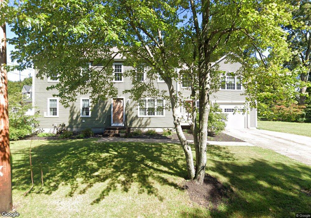
24 Hamilton Rd Wrentham, MA 02093
Estimated Value: $527,000 - $897,000
2
Beds
1
Bath
1,033
Sq Ft
$711/Sq Ft
Est. Value
About This Home
This home is located at 24 Hamilton Rd, Wrentham, MA 02093 and is currently estimated at $734,295, approximately $710 per square foot. 24 Hamilton Rd is a home located in Norfolk County with nearby schools including Delaney Elementary School, Charles E Roderick, and Foxborough Regional Charter School.
Ownership History
Date
Name
Owned For
Owner Type
Purchase Details
Closed on
May 23, 2003
Sold by
Wilson Diane and Wilson Patrick M
Bought by
Collins Robert L and Gay Charlene
Current Estimated Value
Home Financials for this Owner
Home Financials are based on the most recent Mortgage that was taken out on this home.
Original Mortgage
$261,900
Interest Rate
5.86%
Mortgage Type
Purchase Money Mortgage
Purchase Details
Closed on
Jul 17, 2000
Sold by
Flanagan Albert L and Flanagan Andrea M
Bought by
Wilson Patrick M and Wilson Diane
Home Financials for this Owner
Home Financials are based on the most recent Mortgage that was taken out on this home.
Original Mortgage
$164,915
Interest Rate
8.5%
Mortgage Type
Purchase Money Mortgage
Purchase Details
Closed on
Jun 19, 1987
Sold by
Hoar Ellen A
Bought by
Flanagan Albert L
Create a Home Valuation Report for This Property
The Home Valuation Report is an in-depth analysis detailing your home's value as well as a comparison with similar homes in the area
Home Values in the Area
Average Home Value in this Area
Purchase History
| Date | Buyer | Sale Price | Title Company |
|---|---|---|---|
| Collins Robert L | $270,000 | -- | |
| Wilson Patrick M | $165,000 | -- | |
| Flanagan Albert L | $70,000 | -- |
Source: Public Records
Mortgage History
| Date | Status | Borrower | Loan Amount |
|---|---|---|---|
| Open | Flanagan Albert L | $372,000 | |
| Closed | Collins Robert L | $261,900 | |
| Previous Owner | Flanagan Albert L | $166,100 | |
| Previous Owner | Flanagan Albert L | $164,915 |
Source: Public Records
Tax History Compared to Growth
Tax History
| Year | Tax Paid | Tax Assessment Tax Assessment Total Assessment is a certain percentage of the fair market value that is determined by local assessors to be the total taxable value of land and additions on the property. | Land | Improvement |
|---|---|---|---|---|
| 2025 | $8,290 | $715,300 | $290,900 | $424,400 |
| 2024 | $7,942 | $661,800 | $290,900 | $370,900 |
| 2023 | $7,890 | $625,200 | $264,500 | $360,700 |
| 2022 | $6,951 | $508,500 | $203,600 | $304,900 |
| 2021 | $6,955 | $494,300 | $213,300 | $281,000 |
| 2020 | $7,055 | $495,100 | $192,400 | $302,700 |
| 2019 | $6,590 | $466,700 | $177,600 | $289,100 |
| 2018 | $6,922 | $486,100 | $177,600 | $308,500 |
| 2017 | $6,732 | $472,400 | $174,200 | $298,200 |
| 2016 | $6,592 | $461,600 | $169,100 | $292,500 |
| 2015 | $6,374 | $425,500 | $162,600 | $262,900 |
| 2014 | $6,070 | $396,500 | $143,400 | $253,100 |
Source: Public Records
Map
Nearby Homes
- 362 East St
- 1 Lorraine Metcalf Dr
- 270 Dedham St
- 10 Nature View Dr
- 15 Nature View Dr
- 65 Pond St
- 319 Taunton St
- 120 Hawes St
- 131 Creek St Unit 7
- 483 Thurston St
- 11 Earle Stewart Ln
- Lot 3 - 14 Earle Stewart Ln
- Lot 1 - Blueberry 2 Car Plan at King Philip Estates
- Lot 8 - Blueberry 2 Car Plan at King Philip Estates
- Lot 6 - Blueberry 3 Car Plan at King Philip Estates
- Lot 2 - Camden 2 Car Plan at King Philip Estates
- Lot 7 - Cedar Plan at King Philip Estates
- Lot 4 - Hemingway 2 Car Plan at King Philip Estates
- Lot 3 - Blueberry 2 Car Plan at King Philip Estates
- 25 Foxboro Rd
- 89 Woodland Rd
- 40 Hamilton Rd
- 299 East St
- 35 Hamilton Rd
- 85 Woodland Rd
- 41 Hamilton Rd
- 46 Hamilton Rd
- 343 East St
- 49 Hamilton Rd
- 54 Hamilton Rd
- 86 Woodland Rd
- 75 Woodland Rd
- 349 East St Unit 3
- 349 East St Unit 1
- 349 East St
- 349 East St Unit 4
- 349 East St Unit 5
- 349 East St Unit 6
- 80 Woodland Rd
- 69 Woodland Rd