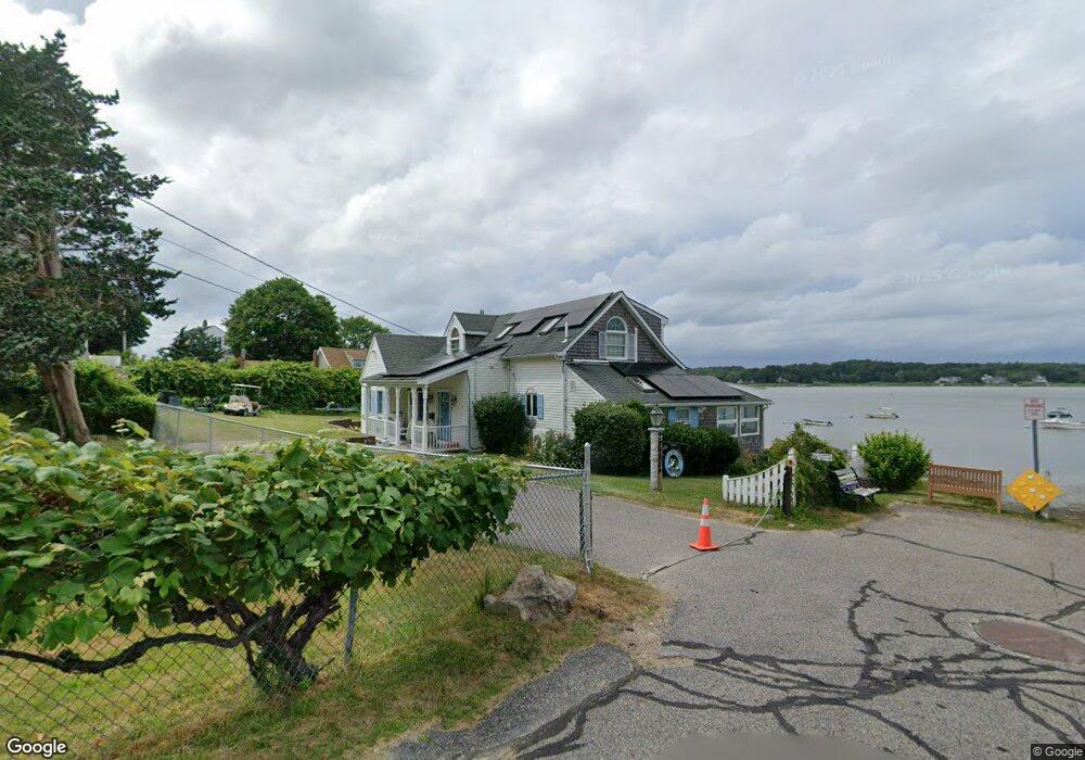
24 Holmes Ave Kingston, MA 02364
Estimated Value: $1,162,902 - $2,067,000
3
Beds
2
Baths
1,815
Sq Ft
$774/Sq Ft
Est. Value
About This Home
This home is located at 24 Holmes Ave, Kingston, MA 02364 and is currently estimated at $1,404,476, approximately $773 per square foot. 24 Holmes Ave is a home located in Plymouth County with nearby schools including Kingston Elementary School, Silver Lake Regional High School, and Kingston Intermediate School.
Ownership History
Date
Name
Owned For
Owner Type
Purchase Details
Closed on
Aug 23, 2012
Sold by
Mcsherry George F and Mcsherry Carolyn J
Bought by
Gillis Brian J and Gillis Ingrid E
Current Estimated Value
Purchase Details
Closed on
Jul 2, 2009
Sold by
Mcsherry George F
Bought by
Mcsherry George F and Mcsherry Carolyn J
Create a Home Valuation Report for This Property
The Home Valuation Report is an in-depth analysis detailing your home's value as well as a comparison with similar homes in the area
Home Values in the Area
Average Home Value in this Area
Purchase History
| Date | Buyer | Sale Price | Title Company |
|---|---|---|---|
| Gillis Brian J | $700,000 | -- | |
| Mcsherry George F | -- | -- | |
| Mcsherry George F | -- | -- |
Source: Public Records
Mortgage History
| Date | Status | Borrower | Loan Amount |
|---|---|---|---|
| Previous Owner | Mcsherry George F | $937,500 | |
| Previous Owner | Mcsherry George F | $359,650 | |
| Previous Owner | Mcsherry George F | $236,000 |
Source: Public Records
Tax History
| Year | Tax Paid | Tax Assessment Tax Assessment Total Assessment is a certain percentage of the fair market value that is determined by local assessors to be the total taxable value of land and additions on the property. | Land | Improvement |
|---|---|---|---|---|
| 2025 | $13,664 | $1,053,502 | $577,202 | $476,300 |
| 2024 | $12,904 | $1,015,302 | $577,202 | $438,100 |
| 2023 | $12,434 | $930,702 | $577,202 | $353,500 |
| 2022 | $12,931 | $886,929 | $555,329 | $331,600 |
| 2021 | $13,311 | $827,827 | $544,127 | $283,700 |
| 2020 | $13,258 | $814,400 | $530,700 | $283,700 |
| 2019 | $12,230 | $743,000 | $507,700 | $235,300 |
| 2018 | $11,780 | $716,100 | $507,700 | $208,400 |
| 2017 | $10,565 | $640,300 | $461,000 | $179,300 |
| 2016 | $11,464 | $651,000 | $448,800 | $202,200 |
| 2015 | $11,075 | $653,800 | $448,800 | $205,000 |
| 2014 | $10,628 | $637,200 | $429,500 | $207,700 |
Source: Public Records
Map
Nearby Homes
- 13 Atwood St
- 12 Curtis Ave
- 35 River St
- Lot 17-3 Howlands Ln
- 8 Blair Dr
- 735 Bay Rd
- 44 Seabury Point Rd
- 40 Landing Rd
- 111 Loring St
- 20 Seabury Point Rd
- 94 Main St
- 17 Howlands Ln
- 100 Parks St Unit 32
- 10 Summerhouse Ln
- 58 Bay Farm Rd
- 12 Smiths Ln
- 12 Spruce Ln
- Lot 17-1 Howland's Ln
- 149 Summer St
- 372 Tremont St
Your Personal Tour Guide
Ask me questions while you tour the home.