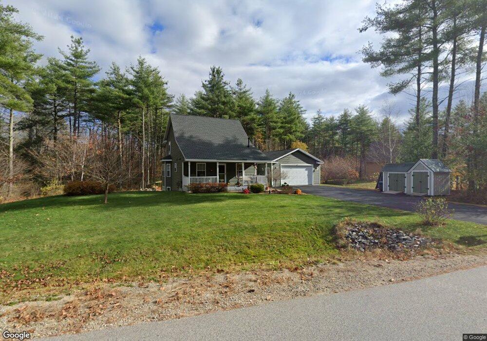
24 Joshua Ln Hollis Center, ME 04042
Hollis NeighborhoodEstimated Value: $353,017 - $504,000
--
Bed
--
Bath
--
Sq Ft
2.78
Acres
About This Home
This home is located at 24 Joshua Ln, Hollis Center, ME 04042 and is currently estimated at $441,254. 24 Joshua Ln is a home with nearby schools including Bonny Eagle High School.
Ownership History
Date
Name
Owned For
Owner Type
Purchase Details
Closed on
Apr 24, 2013
Sold by
Rrr Ent Inc
Bought by
Bowley Lawrence D
Current Estimated Value
Home Financials for this Owner
Home Financials are based on the most recent Mortgage that was taken out on this home.
Original Mortgage
$188,000
Outstanding Balance
$133,719
Interest Rate
3.64%
Mortgage Type
Purchase Money Mortgage
Estimated Equity
$307,535
Purchase Details
Closed on
Apr 16, 2013
Sold by
Littlefield Constr
Bought by
Rrr Ent Inc
Home Financials for this Owner
Home Financials are based on the most recent Mortgage that was taken out on this home.
Original Mortgage
$188,000
Outstanding Balance
$133,719
Interest Rate
3.64%
Mortgage Type
Purchase Money Mortgage
Estimated Equity
$307,535
Create a Home Valuation Report for This Property
The Home Valuation Report is an in-depth analysis detailing your home's value as well as a comparison with similar homes in the area
Home Values in the Area
Average Home Value in this Area
Purchase History
| Date | Buyer | Sale Price | Title Company |
|---|---|---|---|
| Bowley Lawrence D | -- | -- | |
| Rrr Ent Inc | -- | -- |
Source: Public Records
Mortgage History
| Date | Status | Borrower | Loan Amount |
|---|---|---|---|
| Open | Bowley Lawrence D | $188,000 |
Source: Public Records
Tax History Compared to Growth
Tax History
| Year | Tax Paid | Tax Assessment Tax Assessment Total Assessment is a certain percentage of the fair market value that is determined by local assessors to be the total taxable value of land and additions on the property. | Land | Improvement |
|---|---|---|---|---|
| 2024 | $3,456 | $230,400 | $64,700 | $165,700 |
| 2023 | $3,341 | $230,400 | $64,700 | $165,700 |
| 2022 | $3,456 | $230,400 | $64,700 | $165,700 |
| 2021 | $3,283 | $230,400 | $64,700 | $165,700 |
| 2020 | $3,226 | $230,400 | $64,700 | $165,700 |
| 2019 | $3,168 | $230,400 | $64,700 | $165,700 |
| 2018 | $3,053 | $230,400 | $64,700 | $165,700 |
| 2017 | $2,880 | $230,400 | $64,700 | $165,700 |
| 2016 | $2,753 | $230,400 | $64,700 | $165,700 |
| 2015 | $2,499 | $209,120 | $64,700 | $144,420 |
| 2014 | $383 | $33,290 | $33,290 | $0 |
| 2013 | $391 | $35,570 | $35,570 | $0 |
Source: Public Records
Map
Nearby Homes