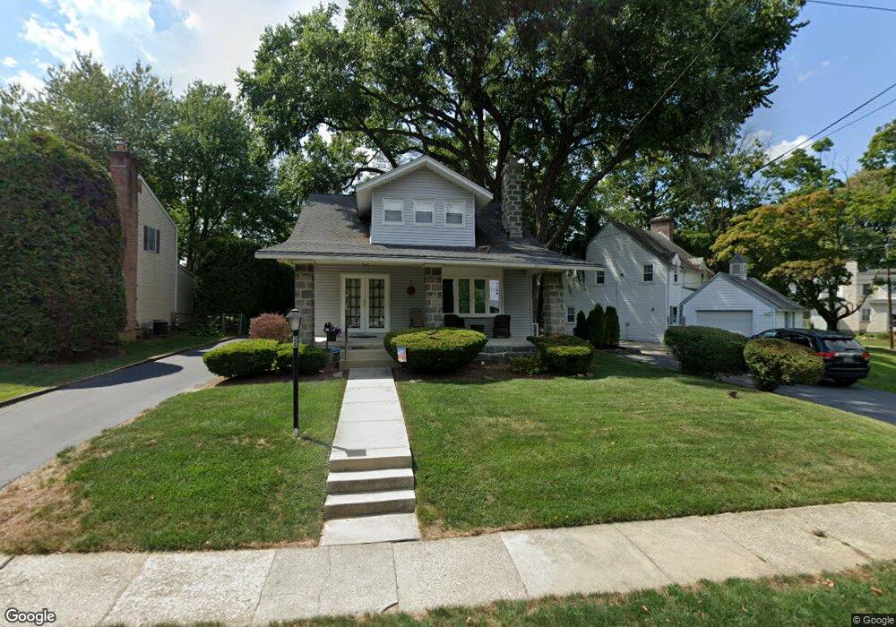
24 Lownes Ln Springfield, PA 19064
Estimated Value: $524,651 - $575,000
4
Beds
2
Baths
2,000
Sq Ft
$276/Sq Ft
Est. Value
About This Home
This home is located at 24 Lownes Ln, Springfield, PA 19064 and is currently estimated at $552,913, approximately $276 per square foot. 24 Lownes Ln is a home located in Delaware County with nearby schools including Springfield High School, St Francis Of Assisi School, and Holy Cross School.
Ownership History
Date
Name
Owned For
Owner Type
Purchase Details
Closed on
Mar 5, 1999
Sold by
Backall Steven M and Backall Lori A
Bought by
Backall Steven M and Backall Lori A
Current Estimated Value
Home Financials for this Owner
Home Financials are based on the most recent Mortgage that was taken out on this home.
Original Mortgage
$115,000
Interest Rate
6.78%
Create a Home Valuation Report for This Property
The Home Valuation Report is an in-depth analysis detailing your home's value as well as a comparison with similar homes in the area
Home Values in the Area
Average Home Value in this Area
Purchase History
| Date | Buyer | Sale Price | Title Company |
|---|---|---|---|
| Backall Steven M | -- | -- |
Source: Public Records
Mortgage History
| Date | Status | Borrower | Loan Amount |
|---|---|---|---|
| Closed | Backall Steven M | $115,000 |
Source: Public Records
Tax History
| Year | Tax Paid | Tax Assessment Tax Assessment Total Assessment is a certain percentage of the fair market value that is determined by local assessors to be the total taxable value of land and additions on the property. | Land | Improvement |
|---|---|---|---|---|
| 2025 | $8,226 | $292,660 | $100,570 | $192,090 |
| 2024 | $8,226 | $292,660 | $100,570 | $192,090 |
| 2023 | $7,921 | $292,660 | $100,570 | $192,090 |
| 2022 | $7,749 | $292,660 | $100,570 | $192,090 |
| 2021 | $12,001 | $292,660 | $100,570 | $192,090 |
| 2020 | $5,836 | $128,780 | $48,350 | $80,430 |
| 2019 | $5,699 | $128,780 | $48,350 | $80,430 |
| 2018 | $5,617 | $128,780 | $0 | $0 |
| 2017 | $5,487 | $128,780 | $0 | $0 |
| 2016 | $707 | $128,780 | $0 | $0 |
| 2015 | $721 | $128,780 | $0 | $0 |
| 2014 | $721 | $128,780 | $0 | $0 |
Source: Public Records
Map
Nearby Homes
- 120 W Springfield Rd
- 111 Forest Rd
- 29 School Ln
- 226 Lynbrooke Rd
- 606 W Springfield Rd
- 147 Snyder Ln
- 31 Wayfield Rd
- 364 S Rolling Rd
- 227 E Leamy Ave
- 220 N Rolling Rd
- 501 Flora Cir
- 332 Franklin Ave
- 641 W Sproul Rd
- 493 Wheatsheaf Rd
- 173 Rambling Way
- 412 N Rolling Rd
- 472 Larchwood Rd
- 514 Springview Ln
- 1291 Country Club Dr Unit Q137
- 1299 Country Club Dr Unit Q141
- 28 Lownes Ln
- 20 Lownes Ln
- 143 S Highland Rd
- 34 Lownes Ln
- 29 Lownes Ln
- 151 S Highland Rd
- 38 Lownes Ln
- 126 S Highland Rd
- 122 S Highland Rd
- 132 S Highland Rd
- 23 Lownes Ln
- 120 S Highland Rd
- 112 S Highland Rd
- 17 Lownes Ln
- 138 S Highland Rd
- 155 S Highland Rd
- 39 Lownes Ln
- 44 Lownes Ln
- 158 Reese Rd
- 144 S Highland Rd
Your Personal Tour Guide
Ask me questions while you tour the home.