
24 Minnetuxet Way Yarmouth Port, MA 02675
Yarmouth Port NeighborhoodEstimated payment $6,110/month
Highlights
- 2.81 Acre Lot
- Wood Flooring
- No HOA
- Deck
- 2 Fireplaces
- 2 Car Attached Garage
About This Home
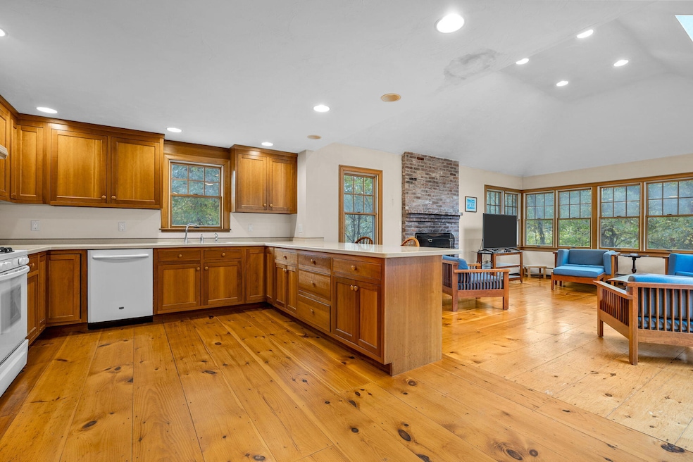
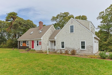
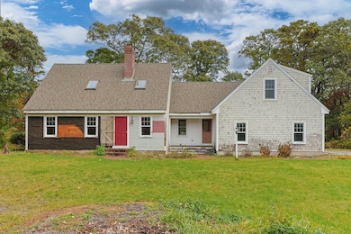
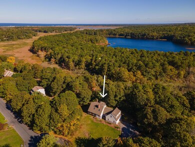
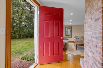
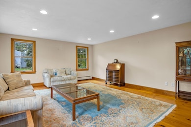
Welcome to this beautiful Cape Cod-style home featuring warm wood floors and a bright, open kitchen and family room--perfect for everyday living and entertaining. Tucked away in a small cul-de-sac neighborhood, this property offers peace, privacy, and a true sense of community.Set on an expansive, almost 3-acre lot, the home provides plenty of room to relax, garden, or enjoy outdoor activities. With just a bit of exterior sprucing up, this could easily become the dream Cape Cod retreat you've been searching for.Located just a mile from Grays Beach, you'll love the coastal lifestyle this home offers--close to sandy shores, local shops, and scenic walking trails. Don't miss this diamond in the rough in a wonderful beachy neighborhood. Come see its potential today!
Listing Agent
William Raveis Real Estate & Home Services License #9085936 Listed on: 10/16/2025

Home Details
Home Type
- Single Family
Est. Annual Taxes
- $7,241
Year Built
- Built in 1996
Lot Details
- 2.81 Acre Lot
- Garden
Parking
- 2 Car Attached Garage
- Basement Garage
Home Design
- Poured Concrete
- Asphalt Roof
- Clapboard
Interior Spaces
- 2,228 Sq Ft Home
- 2-Story Property
- 2 Fireplaces
- Wood Flooring
Bedrooms and Bathrooms
- 3 Bedrooms
- Primary bedroom located on second floor
- Walk-In Closet
- Primary Bathroom is a Full Bathroom
Basement
- Basement Fills Entire Space Under The House
- Interior Basement Entry
Outdoor Features
- Deck
Utilities
- No Cooling
- Hot Water Heating System
- Gas Water Heater
- Septic Tank
Listing and Financial Details
- Assessor Parcel Number YARM M:0124 B:045.1 L:0000
Community Details
Overview
- No Home Owners Association
Recreation
- Community Playground
Map
Home Values in the Area
Average Home Value in this Area
Tax History
| Year | Tax Paid | Tax Assessment Tax Assessment Total Assessment is a certain percentage of the fair market value that is determined by local assessors to be the total taxable value of land and additions on the property. | Land | Improvement |
|---|---|---|---|---|
| 2025 | $7,241 | $1,022,800 | $309,300 | $713,500 |
| 2024 | $6,939 | $940,300 | $299,900 | $640,400 |
| 2023 | $6,825 | $841,600 | $275,400 | $566,200 |
| 2022 | $5,973 | $650,700 | $222,500 | $428,200 |
| 2021 | $6,037 | $631,500 | $239,200 | $392,300 |
| 2020 | $6,115 | $611,500 | $266,100 | $345,400 |
| 2019 | $5,758 | $570,100 | $266,100 | $304,000 |
| 2018 | $5,746 | $558,400 | $254,400 | $304,000 |
| 2017 | $5,595 | $558,400 | $254,400 | $304,000 |
| 2016 | $5,573 | $558,400 | $254,400 | $304,000 |
| 2015 | $5,443 | $542,100 | $254,400 | $287,700 |
Property History
| Date | Event | Price | List to Sale | Price per Sq Ft |
|---|---|---|---|---|
| 11/04/2025 11/04/25 | Price Changed | $1,050,000 | -4.5% | $471 / Sq Ft |
| 10/16/2025 10/16/25 | For Sale | $1,100,000 | -- | $494 / Sq Ft |
Purchase History
| Date | Type | Sale Price | Title Company |
|---|---|---|---|
| Deed | $120,000 | -- |
Mortgage History
| Date | Status | Loan Amount | Loan Type |
|---|---|---|---|
| Open | $299,000 | No Value Available | |
| Closed | $250,000 | No Value Available | |
| Closed | $217,000 | No Value Available | |
| Closed | $108,000 | Purchase Money Mortgage |
Source: Cape Cod & Islands Association of REALTORS®
MLS Number: 22505233
APN: YARM-000124-000045-010000
Disclaimer: Certain information contained herein is derived from information provided by parties other than Homes.com. All information provided is deemed reliable, but is not guaranteed to be accurate and should be independently verified.
![]() All data relating to real estate for sale on this page comes from the Broker Reciprocity (BR) of the Cape Cod & Islands Multiple Listing Service, Inc. Detailed information about real estate listings held by brokerage firms other than CC&I Assoc. of REALTORS®, Inc. includes the name of the listing company. Neither the listing company nor CC&I Assoc. of REALTORS®, Inc. shall be responsible for any typographical errors, misinformation, misprints and shall be held totally harmless. The Broker providing this data believes it to be correct, but advises interested parties to confirm any item before relying on it in a purchase decision. All properties are subject to prior sale, changes, or withdrawal. Copyright 2025 © Cape Cod & Islands Multiple Listing Service, Inc. All rights reserved.
All data relating to real estate for sale on this page comes from the Broker Reciprocity (BR) of the Cape Cod & Islands Multiple Listing Service, Inc. Detailed information about real estate listings held by brokerage firms other than CC&I Assoc. of REALTORS®, Inc. includes the name of the listing company. Neither the listing company nor CC&I Assoc. of REALTORS®, Inc. shall be responsible for any typographical errors, misinformation, misprints and shall be held totally harmless. The Broker providing this data believes it to be correct, but advises interested parties to confirm any item before relying on it in a purchase decision. All properties are subject to prior sale, changes, or withdrawal. Copyright 2025 © Cape Cod & Islands Multiple Listing Service, Inc. All rights reserved.
- 23 Dauphine Dr
- 933-935 W Yarmouth Rd
- 371 Route 6a
- 882 W Yarmouth Rd
- 1 Barnacle Rd
- 2 Pine Grove
- 25 Oak Glen
- 25 Oak Glen Village Unit 25
- 209 Union St
- 7 Forest Gate Unit 7
- 8 Rowley Ln
- 30 W Woods Cir Unit 30
- 30 W Woods
- 86 Pompano Rd
- 32 Deveau Ln
- 43 Canterbury Rd
- 17 Kates Path Unit A
- 34 Kates Path
- 34 Kates Path Unit 34
- 10 Balsam Way
- 25 Embassy Ln
- 25 Embassy St
- 45 Bernard St
- 94 Country Club Dr Unit Apartment
- 6 Lauries Ln
- 12 Town Hall Ave
- 28 Swan Lake Rd
- 265 Communication Way
- 483 Route 28
- 51 Ocean Ave Unit 103
- 40 Bradford Rd
- 99 Wilkens Ln
- 80 Mattakese Rd Unit 7
- 166 Seaview Ave Unit 2a
- 215 W Main St
- 27 Pleasant St
- 7 Columbus Ave
- 40 Pleasant St
- 60 Pleasant St Unit 3B
- 32 Washington Avenue Extension