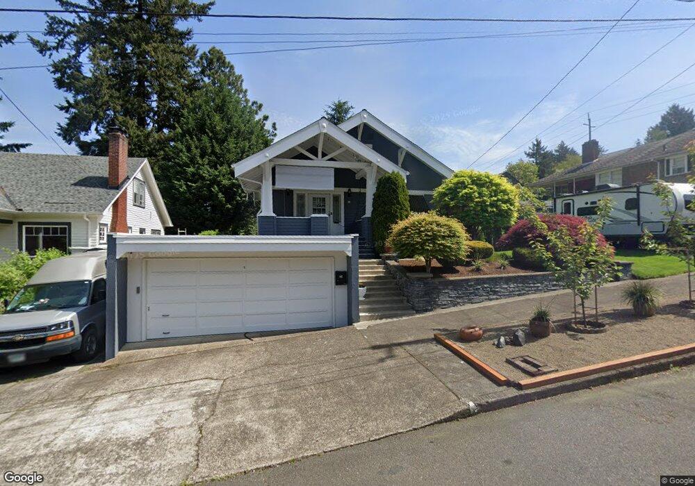
24 NE 67th Ave Portland, OR 97213
North Tabor NeighborhoodEstimated Value: $653,000 - $846,000
2
Beds
1
Bath
1,876
Sq Ft
$390/Sq Ft
Est. Value
About This Home
This home is located at 24 NE 67th Ave, Portland, OR 97213 and is currently estimated at $731,323, approximately $389 per square foot. 24 NE 67th Ave is a home located in Multnomah County with nearby schools including Vestal Elementary School, Leodis V. McDaniel High School, and Portland Arthur Academy.
Ownership History
Date
Name
Owned For
Owner Type
Purchase Details
Closed on
Jan 24, 2005
Sold by
Kendall Nicole Diane
Bought by
Kendall James Edward
Current Estimated Value
Purchase Details
Closed on
May 9, 2003
Sold by
Kendall James Edward
Bought by
Kendall James Edward and Kendall Nicole
Home Financials for this Owner
Home Financials are based on the most recent Mortgage that was taken out on this home.
Original Mortgage
$55,200
Interest Rate
5.71%
Mortgage Type
Purchase Money Mortgage
Create a Home Valuation Report for This Property
The Home Valuation Report is an in-depth analysis detailing your home's value as well as a comparison with similar homes in the area
Home Values in the Area
Average Home Value in this Area
Purchase History
| Date | Buyer | Sale Price | Title Company |
|---|---|---|---|
| Kendall James Edward | -- | -- | |
| Kendall James Edward | -- | Fidelity Natl Title Co Of Or |
Source: Public Records
Mortgage History
| Date | Status | Borrower | Loan Amount |
|---|---|---|---|
| Closed | Kendall James Edward | $55,200 |
Source: Public Records
Tax History Compared to Growth
Tax History
| Year | Tax Paid | Tax Assessment Tax Assessment Total Assessment is a certain percentage of the fair market value that is determined by local assessors to be the total taxable value of land and additions on the property. | Land | Improvement |
|---|---|---|---|---|
| 2024 | $8,285 | $309,650 | -- | -- |
| 2023 | $7,967 | $300,640 | $0 | $0 |
| 2022 | $7,794 | $291,890 | $0 | $0 |
| 2021 | $7,662 | $283,390 | $0 | $0 |
| 2020 | $7,029 | $275,140 | $0 | $0 |
| 2019 | $6,771 | $267,130 | $0 | $0 |
| 2018 | $6,571 | $259,350 | $0 | $0 |
| 2017 | $6,298 | $251,800 | $0 | $0 |
| 2016 | $5,764 | $244,470 | $0 | $0 |
| 2015 | $5,613 | $237,350 | $0 | $0 |
| 2014 | $5,528 | $230,440 | $0 | $0 |
Source: Public Records
Map
Nearby Homes
- 6541 E Burnside St
- 6647 SE Thorburn St
- 0 SE Ash Place Unit 10 24522620
- 304 NE 63rd Ave
- 6505 SE Thorburn St
- 6825 SE Pine Ct
- 44 SE 71st Ave
- 6134 E Burnside St
- 215 NE 72nd Ave
- 541 NE 70th Ave
- 232 NE 61st Ave
- 7020 NE Hoyt St
- 704 NE 68th Ave
- 6055 E Burnside St
- 223 SE 62nd Ave
- 350 NE 61st Ave
- 475 NE 72nd Ave Unit 7
- 424 NE 61st Ave Unit 426
- 235 NE 61st Ave Unit 36
- 481 NE 72nd Ave Unit 4
- 104 NE 67th Ave
- 6705 E Burnside St
- 6725 E Burnside St
- 25 NE Gilham Ave
- 35 NE Gilham Ave
- 114 NE 67th Ave
- 6663 E Burnside St
- 6739 E Burnside St Unit 6741
- 21 NE 67th Ave
- 115 NE Gilham Ave
- 6680 NE Davis St
- 103 NE 67th Ave
- 6651 E Burnside St Unit 6653
- 6650 E Burnside St
- 111 NE 67th Ave
- 6630 NE Davis St
- 6700 E Burnside St
- 30 NE Gilham Ave
- 6641 E Burnside St
- 6641 E Burnside St Unit 2