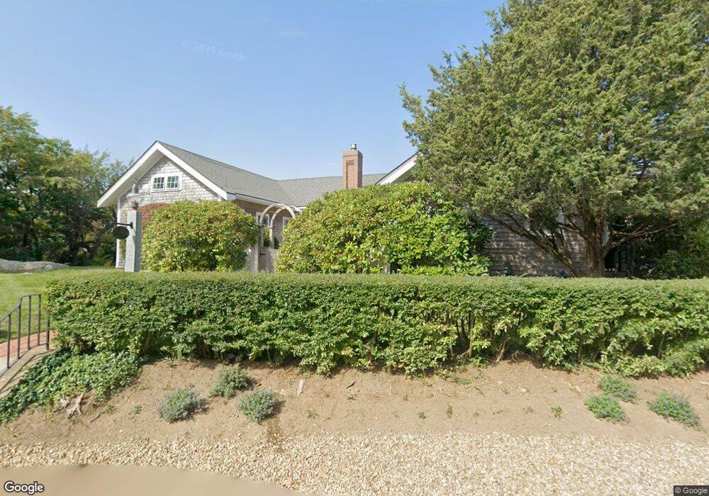
24 Norrock Rd Gloucester, MA 01930
Annisquam NeighborhoodEstimated Value: $1,439,000 - $2,892,000
4
Beds
2
Baths
2,346
Sq Ft
$948/Sq Ft
Est. Value
About This Home
This home is located at 24 Norrock Rd, Gloucester, MA 01930 and is currently estimated at $2,225,017, approximately $948 per square foot. 24 Norrock Rd is a home located in Essex County with nearby schools including Plum Cove School, Ralph B O'maley Middle School, and Gloucester High School.
Ownership History
Date
Name
Owned For
Owner Type
Purchase Details
Closed on
Oct 23, 2020
Sold by
Rosalind Parry Ret
Bought by
24 Norrock Road Llc
Current Estimated Value
Purchase Details
Closed on
Jun 20, 2016
Sold by
Rosalind Parry Ret
Bought by
24 Norrock Road Llc
Purchase Details
Closed on
Sep 17, 2009
Sold by
Parry Rosalind and Parry David C
Bought by
Rosalind Parry Ret
Home Financials for this Owner
Home Financials are based on the most recent Mortgage that was taken out on this home.
Original Mortgage
$650,000
Interest Rate
5.28%
Purchase Details
Closed on
Jun 6, 2002
Sold by
Beck Ronald E and Beck Joann J
Bought by
Parry David C and Parry Rosalind
Home Financials for this Owner
Home Financials are based on the most recent Mortgage that was taken out on this home.
Original Mortgage
$712,500
Interest Rate
6.9%
Mortgage Type
Purchase Money Mortgage
Purchase Details
Closed on
Jan 30, 1998
Sold by
Onthank Elmer A and Onthank Ruth F
Bought by
Beck Ronald E and Beck Joann
Create a Home Valuation Report for This Property
The Home Valuation Report is an in-depth analysis detailing your home's value as well as a comparison with similar homes in the area
Home Values in the Area
Average Home Value in this Area
Purchase History
| Date | Buyer | Sale Price | Title Company |
|---|---|---|---|
| 24 Norrock Road Llc | -- | None Available | |
| 24 Norrock Road Llc | -- | -- | |
| Rosalind Parry Ret | -- | -- | |
| Parry David C | $950,000 | -- | |
| Beck Ronald E | $400,000 | -- |
Source: Public Records
Mortgage History
| Date | Status | Borrower | Loan Amount |
|---|---|---|---|
| Previous Owner | Beck Ronald E | $650,000 | |
| Previous Owner | Beck Ronald E | $699,879 | |
| Previous Owner | Beck Ronald E | $712,500 | |
| Previous Owner | Beck Ronald E | $50,000 |
Source: Public Records
Tax History Compared to Growth
Tax History
| Year | Tax Paid | Tax Assessment Tax Assessment Total Assessment is a certain percentage of the fair market value that is determined by local assessors to be the total taxable value of land and additions on the property. | Land | Improvement |
|---|---|---|---|---|
| 2025 | $20,091 | $2,064,900 | $1,331,100 | $733,800 |
| 2024 | $20,091 | $2,064,900 | $1,331,100 | $733,800 |
| 2023 | $18,603 | $1,756,700 | $1,135,500 | $621,200 |
| 2022 | $17,929 | $1,528,500 | $986,600 | $541,900 |
| 2021 | $17,052 | $1,370,700 | $845,200 | $525,500 |
| 2020 | $16,446 | $1,333,800 | $845,200 | $488,600 |
| 2019 | $16,187 | $1,275,600 | $805,900 | $469,700 |
| 2018 | $16,056 | $1,241,800 | $786,200 | $455,600 |
| 2017 | $15,620 | $1,184,200 | $748,900 | $435,300 |
| 2016 | $14,929 | $1,096,900 | $715,700 | $381,200 |
| 2015 | $14,589 | $1,068,800 | $699,400 | $369,400 |
Source: Public Records
Map
Nearby Homes
- 4 Lane Rd
- 3 Colburn St
- 3 Colburn St Unit 2
- 3 Colburn St Unit 1
- 962 Washington St
- 6 Mount Locust Place Unit 2
- 6 River Rd
- 79 Dennison St
- 672 Washington St
- 226 Atlantic St
- 9 Sandy Way
- 188 Atlantic St
- 178 Atlantic St
- 2 Norseman Ave
- 51 Wingaersheek Rd
- 49 Thurston Point Rd
- 16 Reynard St
- 25 Stockholm Ave
- 28 Riverview Rd Unit B
- 26 Quarry Ridge Ln