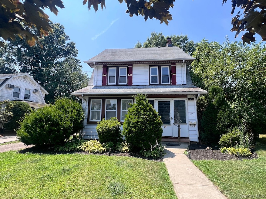
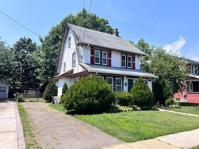
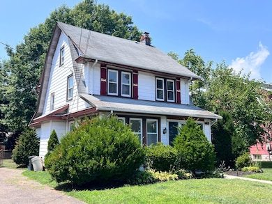
24 Parsons Dr Hempstead, NY 11550
Estimated payment $4,233/month
Highlights
- Colonial Architecture
- 1 Fireplace
- Porch
- Wood Flooring
- Formal Dining Room
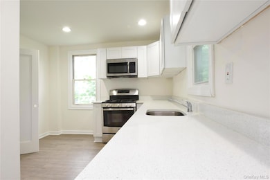
- Eat-In Kitchen
About This Home
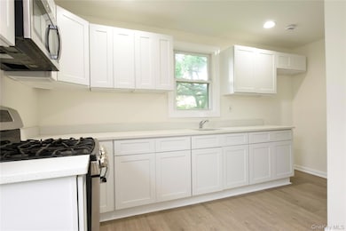
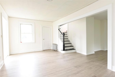
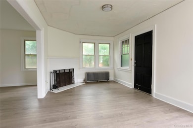
Welcome to this charming single-family home in a prime location! The first floor features a warm and inviting living room with a cozy fireplace, a spacious formal dining room perfect for entertaining, a dedicated home office, and a functional kitchen. Upstairs, you'll find three comfortable bedrooms and a full bathroom. Outside, enjoy a grassy front yard, a welcoming front porch, and an extended private driveway offering ample parking. Location is everything — just minutes from the LIRR, Hofstra University, and the UBS Arena. You'll also be close to the Roosevelt Field Mall and major shopping areas, including supermarkets, restaurants, and home improvement stores on Front St and Fulton Ave. A great opportunity in a highly accessible and vibrant neighborhood!
Listing Agent
EXP Realty Brokerage Phone: 888-276-0630 License #10301205219 Listed on: 07/10/2025

Home Details
Home Type
- Single Family
Est. Annual Taxes
- $11,141
Year Built
- Built in 1920
Lot Details
- 6,000 Sq Ft Lot
- Lot Dimensions are 50 x 120
Home Design
- Colonial Architecture
- Frame Construction
Interior Spaces
- 1,470 Sq Ft Home
- 2-Story Property
- 1 Fireplace
- Formal Dining Room
- Storage
- Wood Flooring
- Basement Fills Entire Space Under The House
Kitchen
- Eat-In Kitchen
- Oven
- Microwave
Bedrooms and Bathrooms
- 3 Bedrooms
- 1 Full Bathroom
Outdoor Features
- Porch
Schools
- David Paterson Elementary School
- Alverta B Gray Schultz Middle Sch
- Hempstead High School
Utilities
- No Cooling
- Heating System Uses Steam
- Heating System Uses Natural Gas
Listing and Financial Details
- Legal Lot and Block 15 / 455
- Assessor Parcel Number 2013-35-455-00-0015-0
Map
Home Values in the Area
Average Home Value in this Area
Tax History
| Year | Tax Paid | Tax Assessment Tax Assessment Total Assessment is a certain percentage of the fair market value that is determined by local assessors to be the total taxable value of land and additions on the property. | Land | Improvement |
|---|---|---|---|---|
| 2025 | $7,944 | $439 | $169 | $270 |
| 2024 | $1,012 | $439 | $169 | $270 |
| 2023 | $2,089 | $439 | $169 | $270 |
| 2022 | $2,089 | $439 | $169 | $270 |
| 2021 | $2,554 | $426 | $164 | $262 |
| 2020 | $1,556 | $467 | $276 | $191 |
| 2019 | $916 | $467 | $276 | $191 |
| 2018 | $779 | $467 | $0 | $0 |
| 2017 | $72 | $467 | $276 | $191 |
| 2016 | $603 | $467 | $276 | $191 |
| 2015 | $434 | $467 | $276 | $191 |
| 2014 | $434 | $467 | $276 | $191 |
| 2013 | $398 | $467 | $276 | $191 |
Property History
| Date | Event | Price | List to Sale | Price per Sq Ft |
|---|---|---|---|---|
| 12/04/2025 12/04/25 | Price Changed | $630,000 | 0.0% | $429 / Sq Ft |
| 12/04/2025 12/04/25 | For Sale | $630,000 | +5.2% | $429 / Sq Ft |
| 09/03/2025 09/03/25 | Pending | -- | -- | -- |
| 07/10/2025 07/10/25 | For Sale | $599,000 | -- | $407 / Sq Ft |
Purchase History
| Date | Type | Sale Price | Title Company |
|---|---|---|---|
| Quit Claim Deed | -- | -- | |
| Bargain Sale Deed | -- | -- | |
| Interfamily Deed Transfer | -- | -- |
Mortgage History
| Date | Status | Loan Amount | Loan Type |
|---|---|---|---|
| Previous Owner | $161,273 | Purchase Money Mortgage |
Source: OneKey® MLS
MLS Number: 879721
APN: 2013-35-455-00-0015-0
Disclaimer: Certain information contained herein is derived from information provided by parties other than Homes.com. All information provided is deemed reliable, but is not guaranteed to be accurate and should be independently verified.
![]() The data relating to real estate for sale or lease on this web site comes in part from OneKey® MLS. Real estate listings held by brokerage firms other than Ten-X are marked with the OneKey® MLS logo or an abbreviated logo and detailed information about them includes the name of the listing broker.
The data relating to real estate for sale or lease on this web site comes in part from OneKey® MLS. Real estate listings held by brokerage firms other than Ten-X are marked with the OneKey® MLS logo or an abbreviated logo and detailed information about them includes the name of the listing broker.
IDX information is provided exclusively for personal, non-commercial use, and may not be used for any purpose other than to identify prospective properties consumers may be interested in purchasing.
Information is deemed reliable but not guaranteed.
Copyright 2025 OneKey® MLS. All rights reserved.
- 60 Parsons Dr
- 14 Parsons Dr
- 44 Saint Pauls Rd S
- 60 Long Dr
- 39 Hilbert St
- 30 Cathedral Ave Unit 4A
- 22 Mulford Place Unit 2D
- 22 Mulford Place Unit 6C
- 31 Grove St
- 78 S Franklin St
- 35 Mulford Place
- 25 Maple Ave
- 23 Maple Ave
- 47 Stratford Rd
- 82 Hilton Ave
- 79 Grove St
- 142 S Franklin St
- 86 Linden Ave
- 7 Seabury St
- 185 Maxine Ct
- 26 Stratford Rd
- 120 Linden Ave
- 130 Hempstead Ave
- 106 Hempstead Turnpike
- 111 Hempstead Turnpike
- 23 Bedell St
- 20 Wendell St
- 134 Alabama Ave
- 457 Front St Unit second floor
- 343 Jackson St Unit 3
- 343 Jackson St Unit 1
- 303 Main St
- 115 Long Beach Rd Unit A
- 17 Stewart Ave
- 539 Front St Unit 4D
- 539 Front St Unit 1D
- 539 Front St Unit 4C
- 539 Front St Unit 2C