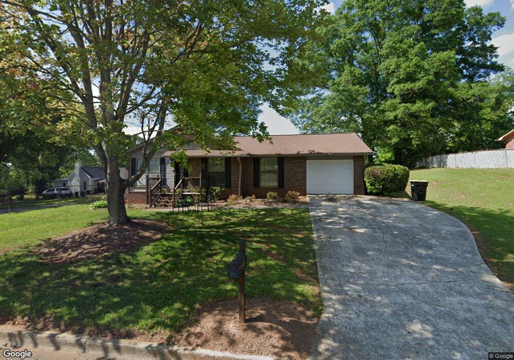
24 Paul St Newnan, GA 30263
Estimated Value: $206,000 - $230,000
3
Beds
1
Bath
1,552
Sq Ft
$138/Sq Ft
Est. Value
About This Home
This home is located at 24 Paul St, Newnan, GA 30263 and is currently estimated at $214,838, approximately $138 per square foot. 24 Paul St is a home located in Coweta County with nearby schools including Welch Elementary School, Lee Middle School, and East Coweta High School.
Ownership History
Date
Name
Owned For
Owner Type
Purchase Details
Closed on
Jun 2, 2002
Sold by
Perdue George
Bought by
Perdue Gail and Perdue Stanley E
Current Estimated Value
Purchase Details
Closed on
Nov 20, 2001
Sold by
Horsley Margine G
Bought by
Gibben Charlie M
Home Financials for this Owner
Home Financials are based on the most recent Mortgage that was taken out on this home.
Original Mortgage
$71,250
Interest Rate
6.54%
Mortgage Type
New Conventional
Purchase Details
Closed on
Dec 31, 1984
Bought by
Gibbs Tyrie Etal
Create a Home Valuation Report for This Property
The Home Valuation Report is an in-depth analysis detailing your home's value as well as a comparison with similar homes in the area
Home Values in the Area
Average Home Value in this Area
Purchase History
| Date | Buyer | Sale Price | Title Company |
|---|---|---|---|
| Perdue Gail | -- | -- | |
| Gibben Charlie M | -- | -- | |
| Gibbs Tyrie Etal | $45,000 | -- |
Source: Public Records
Mortgage History
| Date | Status | Borrower | Loan Amount |
|---|---|---|---|
| Previous Owner | Gibben Charlie M | $71,250 |
Source: Public Records
Tax History Compared to Growth
Tax History
| Year | Tax Paid | Tax Assessment Tax Assessment Total Assessment is a certain percentage of the fair market value that is determined by local assessors to be the total taxable value of land and additions on the property. | Land | Improvement |
|---|---|---|---|---|
| 2024 | $1,609 | $70,423 | $8,800 | $61,623 |
| 2023 | $1,609 | $63,182 | $5,940 | $57,242 |
| 2022 | $1,117 | $45,896 | $4,200 | $41,696 |
| 2021 | $943 | $35,097 | $4,200 | $30,897 |
| 2020 | $965 | $35,097 | $4,200 | $30,897 |
| 2019 | $707 | $23,552 | $3,039 | $20,513 |
| 2018 | $712 | $23,552 | $3,039 | $20,513 |
| 2017 | $585 | $19,450 | $3,039 | $16,411 |
| 2016 | $586 | $19,450 | $3,039 | $16,410 |
| 2015 | $104 | $15,499 | $1,824 | $13,675 |
| 2014 | $110 | $15,499 | $1,824 | $13,675 |
Source: Public Records
Map
Nearby Homes
- 34 Umber Ln Unit LOT 13
- 10 Umber Ln Unit LOT 3
- 36 Mitchell St
- 34 Russet Way Unit LOT 57
- 28 Russet Way Unit LOT 60
- 75 Pinson St
- 30 Pinson St
- 23 Dewey St
- 11 Long St
- 0 Davis St Unit 10606043
- 12 Burch Ave
- 10 Burch Ave
- 19 Landers St
- 16 Kidd St
- 138 Greenville St
- 173 Martin Luther King Dr
- 20 Salbide Ave
- 111 Preserve Dr
- 40 Haynie St
- 65 Tahoe Dr
- 28 Hill St
- 28 Hill St Unit 44
- 26 Paul St Unit 2
- 26 Paul St
- 0 Hill St Unit 8526995
- 0 Hill St Unit 8362286
- 0 Hill St Unit 7381315
- 0 Hill St Unit 7275568
- 0 Paul St Unit 8573861
- 0 Paul St Unit 8483658
- 0 Hill St Unit 8897751
- 0 Hill St Unit 3153608
- 0 Hill St Unit 3111711
- 0 Hill St Unit 7235100
- 0 Hill St Unit 7533905
- 0 Hill St Unit 8743560
- 0 Hill St Unit 34 8756547
- 0 Hill St Unit 38 8755892
- 0 Hill St Unit 26 8770906
- 0 Hill St Unit 8788837