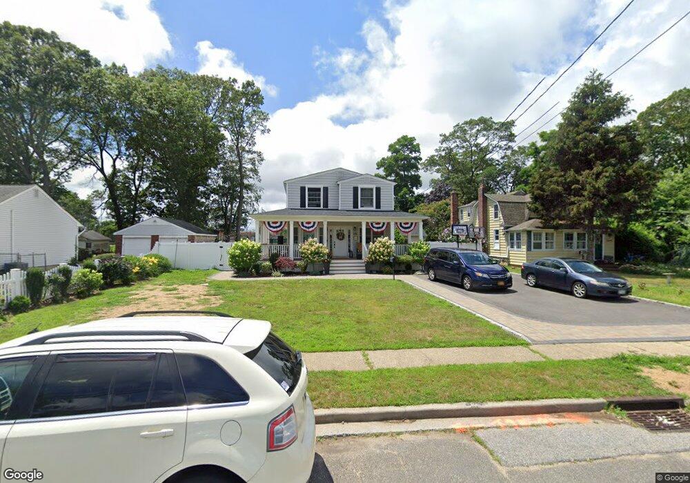
24 Pettit Ave Merrick, NY 11566
Estimated Value: $695,000 - $913,391
--
Bed
3
Baths
2,420
Sq Ft
$332/Sq Ft
Est. Value
About This Home
This home is located at 24 Pettit Ave, Merrick, NY 11566 and is currently estimated at $804,196, approximately $332 per square foot. 24 Pettit Ave is a home located in Nassau County with nearby schools including Merrick Avenue Middle School, Sanford H Calhoun High School, and Sacred Heart School.
Ownership History
Date
Name
Owned For
Owner Type
Purchase Details
Closed on
Jul 22, 2016
Sold by
Martin Sharon M
Bought by
Puglisi Frank S and Puglisi Maria D
Current Estimated Value
Home Financials for this Owner
Home Financials are based on the most recent Mortgage that was taken out on this home.
Original Mortgage
$340,000
Outstanding Balance
$271,247
Interest Rate
3.56%
Mortgage Type
New Conventional
Estimated Equity
$532,949
Create a Home Valuation Report for This Property
The Home Valuation Report is an in-depth analysis detailing your home's value as well as a comparison with similar homes in the area
Home Values in the Area
Average Home Value in this Area
Purchase History
| Date | Buyer | Sale Price | Title Company |
|---|---|---|---|
| Puglisi Frank S | $425,000 | First American Title Insuran | |
| Puglisi Frank S | $425,000 | First American Title Insuran | |
| Puglisi Frank S | $425,000 | First American Title Insuran |
Source: Public Records
Mortgage History
| Date | Status | Borrower | Loan Amount |
|---|---|---|---|
| Open | Puglisi Frank S | $340,000 | |
| Closed | Puglisi Frank S | $340,000 |
Source: Public Records
Tax History Compared to Growth
Tax History
| Year | Tax Paid | Tax Assessment Tax Assessment Total Assessment is a certain percentage of the fair market value that is determined by local assessors to be the total taxable value of land and additions on the property. | Land | Improvement |
|---|---|---|---|---|
| 2025 | $17,260 | $596 | $283 | $313 |
| 2024 | $4,243 | $575 | $273 | $302 |
| 2023 | $18,608 | $594 | $276 | $318 |
| 2022 | $18,608 | $610 | $290 | $320 |
| 2021 | $19,936 | $600 | $285 | $315 |
| 2020 | $14,073 | $758 | $532 | $226 |
| 2019 | $14,108 | $758 | $532 | $226 |
| 2018 | $13,289 | $758 | $0 | $0 |
| 2017 | $5,477 | $758 | $503 | $255 |
| 2016 | $8,645 | $802 | $478 | $324 |
| 2015 | $2,906 | $847 | $505 | $342 |
| 2014 | $2,906 | $847 | $505 | $342 |
| 2013 | $2,775 | $892 | $532 | $360 |
Source: Public Records
Map
Nearby Homes
- 1910 Adair Place
- 1741 Pettit Ave
- 12 Washington Dr
- 2 Garfield St
- 1800 Remson Ave
- 22 Anding Ave
- 1580 Little Whaleneck Rd
- 2005 Abbot Ave
- 1772 Rose St
- 42 E Webster St
- 2125 Burke Place
- 1824 Gildersleeve St
- 19 Margaret Blvd
- 1818 Gormley Ave
- 1707 Carroll Ave
- 1729 Gormley Ave
- 96 Thelma Ave
- 1938 Meadowbrook Rd
- 1931 Miller Place
- 101 Northridge Ave
- 20 Pettit Ave
- 1722 Pettit Ave
- 1700 Pettit Ave
- 1728 Pettit Ave
- 16 Pettit Ave
- 1711 Pettit Ave
- 1719 Pettit Ave
- 1732 Pettit Ave
- 1732 Pettit Ave
- 1705 Pettit Ave
- 1727 Pettit Ave
- 1692 Pettit Ave
- 1738 Pettit Ave
- 1902 Adair Place
- 1697 Pettit Ave
- 1731 Pettit Ave
- 1688 Pettit Ave
- 1742 Pettit Ave
- 67 Camp Ave
- 1735 Pettit Ave