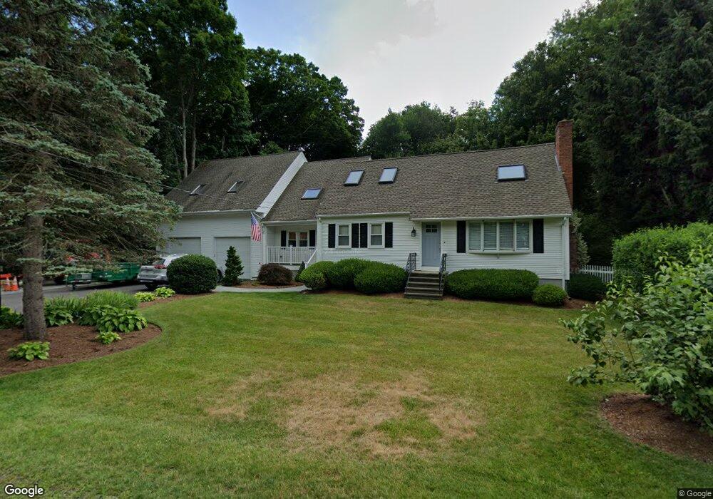
24 Point St Natick, MA 01760
Estimated Value: $1,171,000 - $1,475,000
4
Beds
3
Baths
3,216
Sq Ft
$413/Sq Ft
Est. Value
About This Home
This home is located at 24 Point St, Natick, MA 01760 and is currently estimated at $1,329,738, approximately $413 per square foot. 24 Point St is a home located in Middlesex County with nearby schools including Natick High School, Johnson Elementary School, and J F Kennedy Middle School.
Ownership History
Date
Name
Owned For
Owner Type
Purchase Details
Closed on
Apr 28, 2023
Sold by
Hansen Stephen P and Hansen Nancy A
Bought by
Nesnah Ft
Current Estimated Value
Purchase Details
Closed on
Jun 1, 1983
Bought by
Hansen Stephen P and Hansen Nancy Ann
Create a Home Valuation Report for This Property
The Home Valuation Report is an in-depth analysis detailing your home's value as well as a comparison with similar homes in the area
Home Values in the Area
Average Home Value in this Area
Purchase History
| Date | Buyer | Sale Price | Title Company |
|---|---|---|---|
| Nesnah Ft | -- | None Available | |
| Hansen Stephen P | $74,000 | -- |
Source: Public Records
Mortgage History
| Date | Status | Borrower | Loan Amount |
|---|---|---|---|
| Previous Owner | Hansen Stephen P | $94,000 |
Source: Public Records
Tax History
| Year | Tax Paid | Tax Assessment Tax Assessment Total Assessment is a certain percentage of the fair market value that is determined by local assessors to be the total taxable value of land and additions on the property. | Land | Improvement |
|---|---|---|---|---|
| 2025 | $14,075 | $1,176,800 | $536,100 | $640,700 |
| 2024 | $13,508 | $1,101,800 | $507,800 | $594,000 |
| 2023 | $12,593 | $996,300 | $468,600 | $527,700 |
| 2022 | $12,294 | $921,600 | $419,100 | $502,500 |
| 2021 | $11,767 | $864,600 | $397,000 | $467,600 |
| 2020 | $11,543 | $848,100 | $380,500 | $467,600 |
| 2019 | $10,779 | $848,100 | $380,500 | $467,600 |
| 2018 | $9,892 | $758,000 | $363,900 | $394,100 |
| 2017 | $9,774 | $724,500 | $337,600 | $386,900 |
| 2016 | $9,456 | $696,800 | $313,400 | $383,400 |
| 2015 | $8,846 | $640,100 | $327,000 | $313,100 |
Source: Public Records
Map
Nearby Homes
- 79 Speen St
- 28 Sylvester Rd
- 1 Fern St
- 26 Wellesley Ave Unit B
- 46 Silver Hill Ln Unit 1
- 16 West St
- 36 Silver Hill Ln Unit 21
- 89 W Central St
- 21 Kelsey Rd
- 3 Silver Hill Ln Unit 6
- 1 Post Oak Ln Unit 19
- 62 Oakland St
- 5 Lanes End
- 25 Forest Ave
- 58 W Central St
- 34 Walden Dr Unit 5
- 8 Walden Dr Unit 13
- 157 Mill St
- 9 Bellevue Rd
- 63 Pond St
Your Personal Tour Guide
Ask me questions while you tour the home.