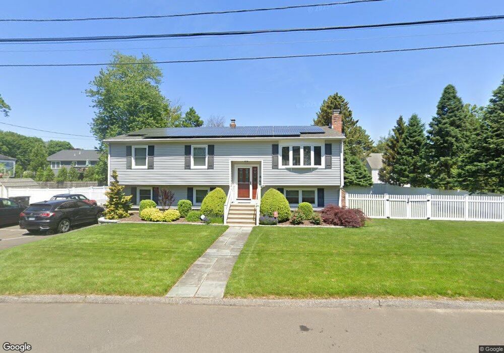
24 Robbie Cir Milford, CT 06460
Devon NeighborhoodEstimated Value: $534,000 - $572,000
3
Beds
3
Baths
1,344
Sq Ft
$418/Sq Ft
Est. Value
About This Home
This home is located at 24 Robbie Cir, Milford, CT 06460 and is currently estimated at $561,362, approximately $417 per square foot. 24 Robbie Cir is a home located in New Haven County with nearby schools including Pumpkin Delight School, West Shore Middle School, and Jonathan Law High School.
Ownership History
Date
Name
Owned For
Owner Type
Purchase Details
Closed on
Mar 2, 1998
Sold by
Malanga Jeffrey P and Malana Annette J
Bought by
Morris John and Delucia Lisa
Current Estimated Value
Home Financials for this Owner
Home Financials are based on the most recent Mortgage that was taken out on this home.
Original Mortgage
$152,000
Interest Rate
6.85%
Mortgage Type
Unknown
Purchase Details
Closed on
Jul 24, 1987
Sold by
Shaw William R
Bought by
Yezzo Joseph M
Create a Home Valuation Report for This Property
The Home Valuation Report is an in-depth analysis detailing your home's value as well as a comparison with similar homes in the area
Home Values in the Area
Average Home Value in this Area
Purchase History
| Date | Buyer | Sale Price | Title Company |
|---|---|---|---|
| Morris John | $160,000 | -- | |
| Morris John | $160,000 | -- | |
| Yezzo Joseph M | $215,000 | -- |
Source: Public Records
Mortgage History
| Date | Status | Borrower | Loan Amount |
|---|---|---|---|
| Open | Yezzo Joseph M | $100,000 | |
| Closed | Yezzo Joseph M | $152,000 | |
| Previous Owner | Yezzo Joseph M | $130,000 |
Source: Public Records
Tax History Compared to Growth
Tax History
| Year | Tax Paid | Tax Assessment Tax Assessment Total Assessment is a certain percentage of the fair market value that is determined by local assessors to be the total taxable value of land and additions on the property. | Land | Improvement |
|---|---|---|---|---|
| 2025 | $8,371 | $283,280 | $96,330 | $186,950 |
| 2024 | $8,255 | $283,280 | $96,330 | $186,950 |
| 2023 | $7,697 | $283,280 | $96,330 | $186,950 |
| 2022 | $7,549 | $283,280 | $96,330 | $186,950 |
| 2021 | $6,019 | $217,700 | $64,580 | $153,120 |
| 2020 | $6,026 | $217,700 | $64,580 | $153,120 |
| 2019 | $6,032 | $217,700 | $64,580 | $153,120 |
| 2018 | $6,039 | $217,700 | $64,580 | $153,120 |
| 2017 | $6,050 | $217,700 | $64,580 | $153,120 |
| 2016 | $5,788 | $207,890 | $64,580 | $143,310 |
| 2015 | $5,796 | $207,890 | $64,580 | $143,310 |
| 2014 | $5,564 | $204,420 | $64,580 | $139,840 |
Source: Public Records
Map
Nearby Homes
- 196 Monroe St
- 20 York St
- 85 Viscount Dr Unit 1C
- 85 Viscount Dr Unit B12
- 85 Viscount Dr Unit 2F
- 0 Saco St
- 49 Overlook Dr
- 25 Lucille Dr
- 101 E Broadway Unit D
- 47 Peak Ave
- 775 Milford Point Rd
- 98 Naugatuck Ave
- 151 Naugatuck Ave
- 96 Naugatuck Ave
- 47 Beach Shore Dr Unit 47
- 63 Stowe Ave
- 58 Laurel Ave
- 9 Stowe Ave
- 15 Pickett St
- 42 Devonshire Rd
- 21 Pomona Ave
- 30 Robbie Cir
- 14 Robbie Cir
- 29 Pomona Ave
- 9 Pomona Ave
- 19 Robbie Cir
- 25 Robbie Cir
- 35 Pomona Ave
- 33 Robbie Cir
- 201 Maplewood Ave
- 197 Maplewood Ave
- 29 Robbie Cir
- 203 Maplewood Ave
- 20 Pomona Ave
- 14 Pomona Ave
- 181 Maplewood Ave
- 43 Pomona Ave
- 30 Pomona Ave
- 26 Jefferson St
- 213 Maplewood Ave