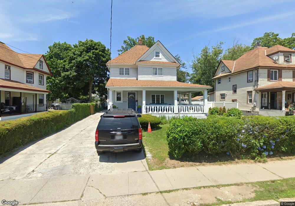
24 Russell Place Freeport, NY 11520
Estimated Value: $619,000 - $652,905
--
Bed
2
Baths
1,626
Sq Ft
$391/Sq Ft
Est. Value
About This Home
This home is located at 24 Russell Place, Freeport, NY 11520 and is currently estimated at $635,953, approximately $391 per square foot. 24 Russell Place is a home located in Nassau County with nearby schools including Caroline G. Atkinson Intermediate School, Columbus Avenue School, and John W Dodd Middle School.
Ownership History
Date
Name
Owned For
Owner Type
Purchase Details
Closed on
Nov 3, 2011
Sold by
Mim Properties Inc
Bought by
Ynoa Ygnacia and Inoa Jenny
Current Estimated Value
Purchase Details
Closed on
Oct 18, 2009
Sold by
American Home Mortgage Corp
Bought by
Mim Properties Inc
Purchase Details
Closed on
Jan 27, 2006
Sold by
Buchanan Brian
Bought by
Cintron Jose
Purchase Details
Closed on
May 16, 1997
Sold by
Rf Properties Corp
Bought by
Buchanan Brian and Buchanan Julie
Purchase Details
Closed on
Feb 27, 1997
Sold by
Herbil Holding Co
Bought by
Rf Properties Corp
Create a Home Valuation Report for This Property
The Home Valuation Report is an in-depth analysis detailing your home's value as well as a comparison with similar homes in the area
Home Values in the Area
Average Home Value in this Area
Purchase History
| Date | Buyer | Sale Price | Title Company |
|---|---|---|---|
| Ynoa Ygnacia | $260,000 | -- | |
| Mim Properties Inc | $143,000 | -- | |
| Cintron Jose | $390,000 | -- | |
| Buchanan Brian | $152,000 | -- | |
| Rf Properties Corp | $86,000 | -- |
Source: Public Records
Tax History Compared to Growth
Tax History
| Year | Tax Paid | Tax Assessment Tax Assessment Total Assessment is a certain percentage of the fair market value that is determined by local assessors to be the total taxable value of land and additions on the property. | Land | Improvement |
|---|---|---|---|---|
| 2025 | $8,690 | $403 | $155 | $248 |
| 2024 | $928 | $410 | $158 | $252 |
| 2023 | $8,603 | $387 | $149 | $238 |
| 2022 | $8,603 | $410 | $158 | $252 |
| 2021 | $13,966 | $392 | $151 | $241 |
| 2020 | $9,945 | $663 | $414 | $249 |
| 2019 | $9,757 | $663 | $414 | $249 |
| 2018 | $9,600 | $663 | $0 | $0 |
| 2017 | $7,979 | $663 | $414 | $249 |
| 2016 | $8,974 | $663 | $414 | $249 |
| 2015 | $958 | $663 | $414 | $249 |
| 2014 | $958 | $663 | $414 | $249 |
| 2013 | $898 | $658 | $414 | $244 |
Source: Public Records
Map
Nearby Homes
- 99 Randall Ave Unit 1Q
- 100 Randall Ave Unit 1E
- 110 Brooklyn Ave Unit 1D
- 101 Wallace St
- 28 Lexington Ave
- 6 New York Ave
- 21 Connecticut Ave
- 235 Pine St
- 27 W Woodbine Dr
- 254 Lena Ave
- 55 S Bergen Place Unit 3F
- 117 N Grove St
- 36 New York Ave
- 70 N Grove St Unit 1R
- 86 N Bayview Ave
- 313 Pine St
- 250 W Merrick Rd Unit 2R
- 250 W Merrick Rd Unit 2 L
- 250 W Merrick Rd Unit 1F
- 250 W Merrick Rd Unit 2F
- 30 Russell Place
- 22 Russell Place
- 34 Russell Place
- 25 Russell Place
- 27 Russell Place Unit 29
- 21 Russell Place
- 33 Russell Place
- 35 Russell Place
- 21 Pearsall Ave
- 25 Pearsall Ave
- 36 Russell Place
- 15 Russell Place
- 17 Pearsall Ave
- 29 Pearsall Ave
- 35 N Long Beach Ave
- 37 Russell Place
- 41 Russell Place
- 7 Russell Place
- 33 Pearsall Ave
- 47 N Long Beach Ave