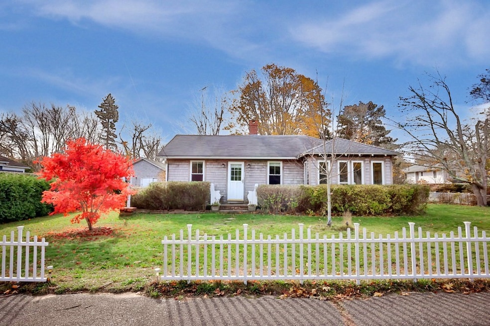
24 School St Oak Bluffs, MA 02557
Oak Bluffs NeighborhoodEstimated payment $4,924/month
Highlights
- Popular Property
- Property is near public transit
- Wood Flooring
- Marina
- Ranch Style House
- Mud Room
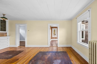
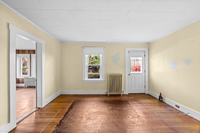
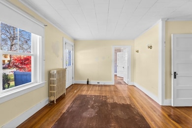
About This Home
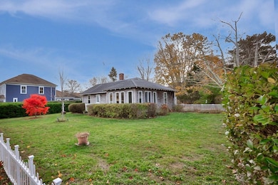
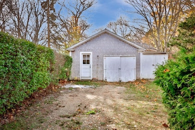
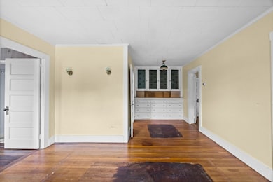
An unbeatable location ~ just a short distance to the harbor, beaches, ferry ports, the public library, and all the vibrant attractions of Oak Bluffs. This 2-bedroom, 1-bathroom ranch-style home is sited on a 10,454 sf level lot with a detached garage/shed. The property offers one-floor living, a convenient location, and great potential. The main living area includes an open living and dining room. The kitchen is at the back of the house with the mudroom and side entrance beyond. Enjoy the beautiful natural light in the spacious sun room at the front of the house with French doors leading to the side yard. The property offers charm and potential in a sought-after location. Several updates were completed in 2010 such as a new roof, windows, and siding (see full list in documents section). The property is being sold “AS IS”. There are 2 existing cesspools on site that failed inspection. Per the Oak Bluffs Wastewater Department, the property can tie into Town sewer.
Home Details
Home Type
- Single Family
Est. Annual Taxes
- $3,808
Year Built
- Built in 1925
Lot Details
- 10,454 Sq Ft Lot
- Level Lot
- Cleared Lot
- Property is zoned R1
Home Design
- Ranch Style House
- Block Foundation
- Shingle Roof
Interior Spaces
- 861 Sq Ft Home
- Decorative Lighting
- Light Fixtures
- French Doors
- Mud Room
Kitchen
- Range
- Microwave
Flooring
- Wood
- Laminate
- Ceramic Tile
Bedrooms and Bathrooms
- 2 Bedrooms
- 1 Full Bathroom
- Separate Shower
Parking
- Detached Garage
- Unpaved Parking
- Open Parking
Location
- Property is near public transit
Utilities
- No Cooling
- Heating System Uses Oil
- Hot Water Heating System
- Electric Water Heater
- Private Sewer
Listing and Financial Details
- Tax Lot 342
- Assessor Parcel Number 3876205
Community Details
Recreation
- Marina
Additional Features
- No Home Owners Association
- Shops
Map
Home Values in the Area
Average Home Value in this Area
Tax History
| Year | Tax Paid | Tax Assessment Tax Assessment Total Assessment is a certain percentage of the fair market value that is determined by local assessors to be the total taxable value of land and additions on the property. | Land | Improvement |
|---|---|---|---|---|
| 2025 | $3,808 | $754,100 | $532,800 | $221,300 |
| 2024 | $3,787 | $724,100 | $484,100 | $240,000 |
| 2023 | $3,896 | $737,900 | $513,200 | $224,700 |
| 2022 | $3,948 | $581,500 | $402,700 | $178,800 |
| 2021 | $3,396 | $460,800 | $302,200 | $158,600 |
| 2020 | $3,236 | $435,000 | $287,800 | $147,200 |
| 2019 | $3,147 | $409,200 | $264,800 | $144,400 |
| 2018 | $2,752 | $351,500 | $207,900 | $143,600 |
| 2017 | $2,636 | $323,400 | $197,100 | $126,300 |
| 2016 | $2,489 | $306,900 | $203,200 | $103,700 |
| 2015 | $2,376 | $298,500 | $203,200 | $95,300 |
| 2014 | $2,238 | $286,600 | $187,400 | $99,200 |
Property History
| Date | Event | Price | List to Sale | Price per Sq Ft |
|---|---|---|---|---|
| 11/13/2025 11/13/25 | For Sale | $875,000 | -- | $1,016 / Sq Ft |
Purchase History
| Date | Type | Sale Price | Title Company |
|---|---|---|---|
| Personal Reps Deed | -- | None Available | |
| Personal Reps Deed | -- | None Available | |
| Deed | -- | -- | |
| Deed | -- | -- | |
| Deed | -- | -- |
Mortgage History
| Date | Status | Loan Amount | Loan Type |
|---|---|---|---|
| Previous Owner | $34,933 | No Value Available | |
| Previous Owner | $411,344 | No Value Available |
Source: MLS Property Information Network (MLS PIN)
MLS Number: 73454444
APN: OAKB-000011-000342
Disclaimer: Certain information contained herein is derived from information provided by parties other than Homes.com. All information provided is deemed reliable, but is not guaranteed to be accurate and should be independently verified.
![]() The property listing data and information, or the Images, set forth herein were provided to MLS Property Information Network, Inc. from third party sources, including sellers, lessors and public records, and were compiled by MLS Property Information Network, Inc. The property listing data and information, and the Images, are for the personal, non-commercial use of consumers having a good faith interest in purchasing or leasing listed properties of the type displayed to them and may not be used for any purpose other than to identify prospective properties which such consumers may have a good faith interest in purchasing or leasing. MLS Property Information Network, Inc. and its subscribers disclaim any and all representations and warranties as to the accuracy of the property listing data and information, or as to the accuracy of any of the Images, set forth herein.
The property listing data and information, or the Images, set forth herein were provided to MLS Property Information Network, Inc. from third party sources, including sellers, lessors and public records, and were compiled by MLS Property Information Network, Inc. The property listing data and information, and the Images, are for the personal, non-commercial use of consumers having a good faith interest in purchasing or leasing listed properties of the type displayed to them and may not be used for any purpose other than to identify prospective properties which such consumers may have a good faith interest in purchasing or leasing. MLS Property Information Network, Inc. and its subscribers disclaim any and all representations and warranties as to the accuracy of the property listing data and information, or as to the accuracy of any of the Images, set forth herein.
- 9 Brunswick Ave
- 10 Siloam Ave
- 26 Hampson Ave
- 1 Cottage Park
- 25 Hampson Ave
- 34 Massasoit Ave
- 2 Lincoln Ave
- 23 Laurel Ave
- 113 Dukes County Ave Unit Multi-Family
- 12 & 14 Maple Ave
- 30 Franklin Ave
- 26 Winthrop Ave
- 46 Kennebec Ave
- 181 Circuit Ave
- 8 Hitchings Cir
- 54 Towanticut Ave
- 38 Rogers Way
- 47 E East Chop Dr Unit 5
- 47 E Chop Dr Unit 4
- 47 E Chop Dr Unit 2
- 5 Laurel Ave
- 14 Pulpit Rock Rd
- 291 Barnes Rd Ob516
- 55 Samoset Ave
- 55 Samoset Ave Unit 1
- 12 John Wesley Ave Ob519
- 59 Prospect Ave Ob502
- 9 Tuckernuck Ave
- 11 High Meadow Ln
- 155 Skiff Ave
- 21 William St Vh430
- 14 Bernard Cir
- 385 Barnes Rd Ob534
- 100 Franklin Terrace Vh411
- 256 Sandpiper Lane Vh417
- 223 Sandpiper Lane Vh405
- 40 Hidden Cove Rd
- 16 Majors Cove Ln
- 83 Ashtons Way
- 100 Connie's Way Vh401
