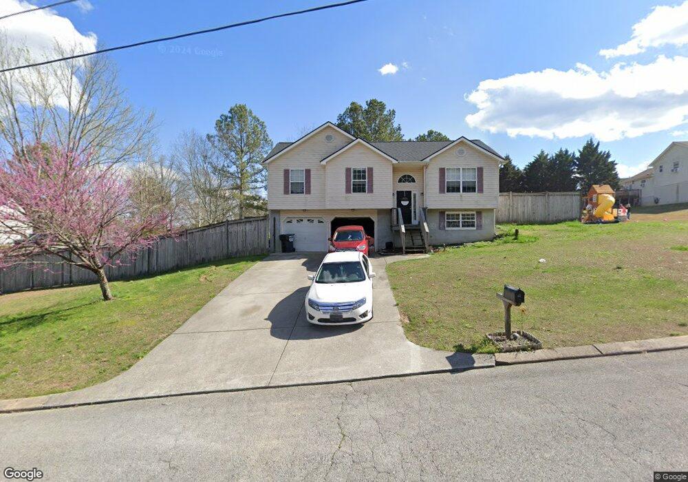
24 Songbird Dr Rock Spring, GA 30739
Beaumont NeighborhoodEstimated Value: $209,473 - $245,000
--
Bed
2
Baths
1,121
Sq Ft
$203/Sq Ft
Est. Value
About This Home
This home is located at 24 Songbird Dr, Rock Spring, GA 30739 and is currently estimated at $228,118, approximately $203 per square foot. 24 Songbird Dr is a home located in Catoosa County with nearby schools including Woodstation Elementary School, Heritage Middle School, and Heritage High School.
Ownership History
Date
Name
Owned For
Owner Type
Purchase Details
Closed on
Sep 15, 2020
Sold by
Ingram Darlene A
Bought by
Fink Brandon Lee and Fink Jessica L
Current Estimated Value
Home Financials for this Owner
Home Financials are based on the most recent Mortgage that was taken out on this home.
Original Mortgage
$89,000
Outstanding Balance
$78,982
Interest Rate
2.9%
Mortgage Type
New Conventional
Estimated Equity
$149,136
Purchase Details
Closed on
Jul 28, 2000
Bought by
Ingram Kenneth H And
Create a Home Valuation Report for This Property
The Home Valuation Report is an in-depth analysis detailing your home's value as well as a comparison with similar homes in the area
Home Values in the Area
Average Home Value in this Area
Purchase History
| Date | Buyer | Sale Price | Title Company |
|---|---|---|---|
| Fink Brandon Lee | $89,000 | -- | |
| Ingram Kenneth H And | $83,000 | -- |
Source: Public Records
Mortgage History
| Date | Status | Borrower | Loan Amount |
|---|---|---|---|
| Open | Fink Brandon Lee | $89,000 |
Source: Public Records
Tax History Compared to Growth
Tax History
| Year | Tax Paid | Tax Assessment Tax Assessment Total Assessment is a certain percentage of the fair market value that is determined by local assessors to be the total taxable value of land and additions on the property. | Land | Improvement |
|---|---|---|---|---|
| 2024 | $1,679 | $78,706 | $10,000 | $68,706 |
| 2023 | $1,358 | $60,637 | $10,000 | $50,637 |
| 2022 | $1,090 | $48,677 | $10,000 | $38,677 |
| 2021 | $745 | $48,677 | $10,000 | $38,677 |
| 2020 | $1,009 | $43,624 | $10,000 | $33,624 |
| 2019 | $974 | $41,624 | $8,000 | $33,624 |
| 2018 | $989 | $40,024 | $6,400 | $33,624 |
| 2017 | $964 | $39,005 | $6,400 | $32,605 |
| 2016 | $936 | $36,011 | $6,400 | $29,611 |
| 2015 | -- | $36,011 | $6,400 | $29,611 |
| 2014 | -- | $36,011 | $6,400 | $29,611 |
| 2013 | -- | $36,011 | $6,400 | $29,611 |
Source: Public Records
Map
Nearby Homes
- 265 Rodeo Dr
- 287 E Teems Rd
- 76 Side Kick Ln
- 0 Temperance Hall Rd Unit 10506446
- 0 Temperance Hall Rd Unit 1510568
- 13 Crosswinds Dr
- 1282 Temperance Hall Rd
- 15 Chickadee Dr
- 0 E Teems Rd Unit 10515523
- 0 E Teems Rd Unit 7573954
- 533 Van Dell Dr
- 201 Van Dell Dr
- 0 Cheshire Crossing Dr Unit 1387793
- 0 Summerfield Trail
- 333 Hooper Rd
- 3255 Colbert Hollow Rd
- 0 Colbert Hollow Rd Unit 1513202
- 819 Waters Dr
- 678 Waters Dr
- 134 Farm View Cir
- 156 Rodeo Dr
- 35 Songbird Dr
- 19 Songbird Dr
- 138 Rodeo Dr
- 55 Songbird Dr
- 0 Hinton Ln Unit RTC2732440
- 0 Hinton Ln Unit 1246643
- 0 Hinton Ln Unit RTC2320240
- 172 Rodeo Dr
- 118 Rodeo Dr
- 189 Rodeo Dr
- 59 Songbird Dr
- 131 Rodeo Dr
- 186 Songbird Dr
- 186 Rodeo Dr
- 96 Rodeo Dr
- 201 E Teems Rd
- 191 E Teems Rd
- 185 E Teems Rd
- 113 Rodeo Dr