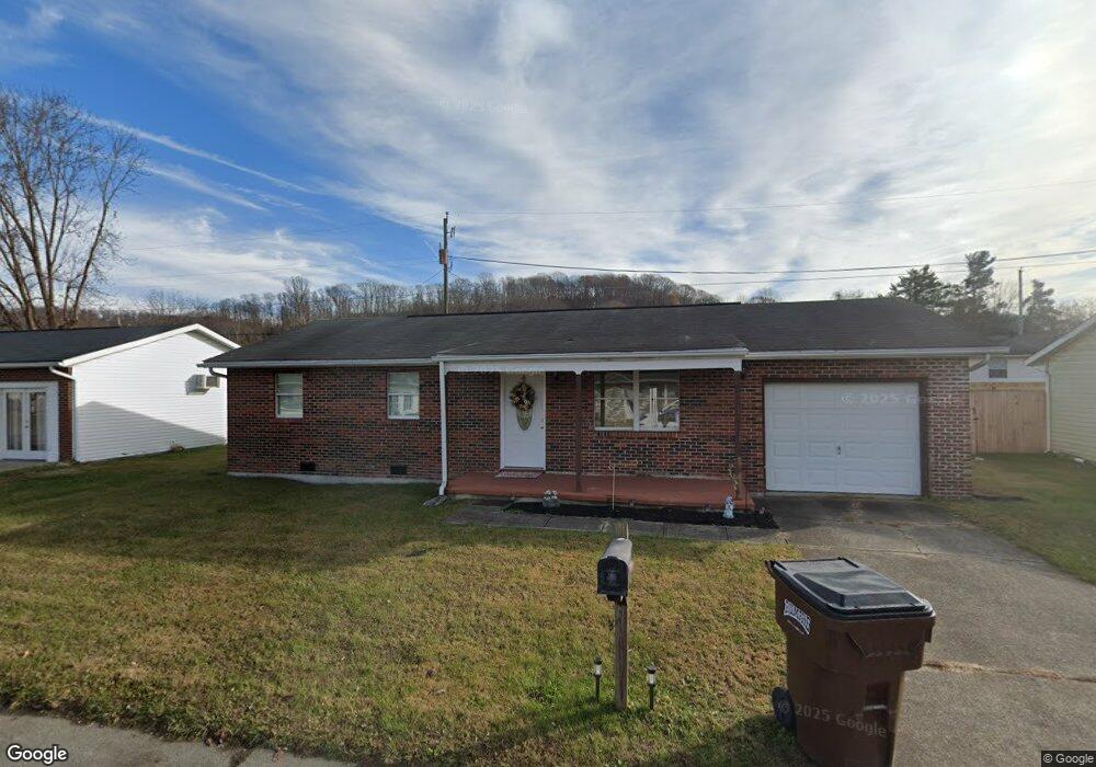
24 Twp Rd 1408 N South Point, OH 45680
Clearview NeighborhoodEstimated Value: $136,000 - $171,000
2
Beds
1
Bath
960
Sq Ft
$159/Sq Ft
Est. Value
About This Home
This home is located at 24 Twp Rd 1408 N, South Point, OH 45680 and is currently estimated at $152,933, approximately $159 per square foot. 24 Twp Rd 1408 N is a home with nearby schools including South Point High School.
Ownership History
Date
Name
Owned For
Owner Type
Purchase Details
Closed on
Aug 20, 2013
Sold by
Morrello Dennis and Morrello Malinda
Bought by
Griswold Kimberly D
Current Estimated Value
Purchase Details
Closed on
Mar 20, 2013
Sold by
Kirby Arthur
Bought by
Morrello Dennis and Morrello Malinda
Purchase Details
Closed on
Feb 28, 1996
Bought by
Kirby Arthur
Purchase Details
Closed on
Mar 31, 1995
Sold by
Arbaugh Gary A and Arbaugh Patric
Bought by
United States Of America
Purchase Details
Closed on
Sep 23, 1988
Sold by
Fitzpatrick William and Fitzpatrick Ru
Bought by
Arbaugh Gary A and Arbaugh Patric
Create a Home Valuation Report for This Property
The Home Valuation Report is an in-depth analysis detailing your home's value as well as a comparison with similar homes in the area
Home Values in the Area
Average Home Value in this Area
Purchase History
| Date | Buyer | Sale Price | Title Company |
|---|---|---|---|
| Griswold Kimberly D | $72,000 | None Available | |
| Morrello Dennis | $34,000 | None Available | |
| Kirby Arthur | -- | -- | |
| United States Of America | -- | -- | |
| Arbaugh Gary A | $41,500 | -- |
Source: Public Records
Tax History Compared to Growth
Tax History
| Year | Tax Paid | Tax Assessment Tax Assessment Total Assessment is a certain percentage of the fair market value that is determined by local assessors to be the total taxable value of land and additions on the property. | Land | Improvement |
|---|---|---|---|---|
| 2024 | -- | $31,100 | $5,230 | $25,870 |
| 2023 | $962 | $31,100 | $5,230 | $25,870 |
| 2022 | $959 | $31,100 | $5,230 | $25,870 |
| 2021 | $806 | $25,350 | $3,480 | $21,870 |
| 2020 | $821 | $25,350 | $3,480 | $21,870 |
| 2019 | $816 | $25,350 | $3,480 | $21,870 |
| 2018 | $827 | $25,350 | $3,480 | $21,870 |
| 2017 | $825 | $25,350 | $3,480 | $21,870 |
| 2016 | $767 | $25,350 | $3,480 | $21,870 |
| 2015 | $629 | $19,540 | $3,480 | $16,060 |
| 2014 | $628 | $19,540 | $3,480 | $16,060 |
| 2013 | $627 | $19,540 | $3,480 | $16,060 |
Source: Public Records
Map
Nearby Homes
- 0 Township Road 161 Unit 182331
- 1225 County Road 15
- 2904 County Road 1
- 719 County Road 15
- 119 County Road 15
- 905 Honeysuckle Ln
- 314 Wadkins St
- 110 Kitts Ln
- 614 Gartrell St
- 0 E Ridge St
- 823 Birch St
- 4863 Richardson Rd
- 102 Park Ave
- 5114 Blackburn Ave
- 5023 King Richard Ct
- 3421 Central Ave
- 0 Wallace St
- 108 Ferry St
- 3907 Avery St
- 0 County Road 1
- 1408 N Ann St
- 10 Township Road 1408 N
- 38 Township Road 1408 N
- 25 Twp Rd 1408 N
- 85 Township Road 1467
- 11 Township Road 1408 N
- 37 Twp Rd 1408 N
- 37 Township Road 1408 N
- 97 Township Road 1467
- 71 Township Road 1467
- 46 Twp Rd 1408 N
- 46 Township Road 1408 N
- 47 Twp Rd 1408 N
- 9 Twp Rd 1408 S
- 10 Twp Rd 1408 S
- 51 Township Road 1467
- 48 Tr 510 N
- 84 Township Road 1467
- 84 Township Road 1467 Unit 2
- 21 Township Road 1408 N