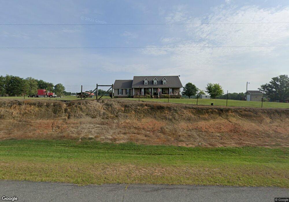
240 Benny Sharp Rd Hawkinsville, GA 31036
Estimated Value: $288,000 - $521,000
3
Beds
3
Baths
2,374
Sq Ft
$154/Sq Ft
Est. Value
About This Home
This home is located at 240 Benny Sharp Rd, Hawkinsville, GA 31036 and is currently estimated at $365,996, approximately $154 per square foot. 240 Benny Sharp Rd is a home located in Pulaski County with nearby schools including Pulaski County Elementary School, Pulaski County Middle School, and Hawkinsville High School.
Ownership History
Date
Name
Owned For
Owner Type
Purchase Details
Closed on
Dec 31, 2015
Bought by
White Robin C
Current Estimated Value
Purchase Details
Closed on
Jun 9, 2008
Sold by
White Ketn D
Bought by
White Robin C
Create a Home Valuation Report for This Property
The Home Valuation Report is an in-depth analysis detailing your home's value as well as a comparison with similar homes in the area
Home Values in the Area
Average Home Value in this Area
Purchase History
| Date | Buyer | Sale Price | Title Company |
|---|---|---|---|
| White Robin C | $165,100 | -- | |
| White Robin C | -- | -- |
Source: Public Records
Tax History Compared to Growth
Tax History
| Year | Tax Paid | Tax Assessment Tax Assessment Total Assessment is a certain percentage of the fair market value that is determined by local assessors to be the total taxable value of land and additions on the property. | Land | Improvement |
|---|---|---|---|---|
| 2024 | $2,820 | $122,145 | $2,533 | $119,612 |
| 2023 | $2,820 | $62,037 | $2,208 | $59,829 |
| 2022 | $1,718 | $62,037 | $2,208 | $59,829 |
| 2021 | $1,722 | $62,037 | $2,208 | $59,829 |
| 2020 | $1,728 | $62,037 | $2,208 | $59,829 |
| 2019 | $1,726 | $62,037 | $2,208 | $59,829 |
| 2018 | $1,785 | $62,037 | $2,208 | $59,829 |
| 2017 | $1,785 | $62,037 | $2,208 | $59,829 |
| 2016 | $1,727 | $62,037 | $2,208 | $59,829 |
| 2015 | -- | $62,037 | $2,208 | $59,829 |
| 2014 | -- | $62,037 | $2,208 | $59,829 |
| 2013 | -- | $62,036 | $2,208 | $59,828 |
Source: Public Records
Map
Nearby Homes
- 0 Benny Sharp Rd
- 91 Cole Dr
- 0 Craftway Dr Unit 253517
- 105 Westgate Plaza
- 97 Westgate Plaza
- 0 Abbeville Hwy Unit 10585807
- 0 Margaret Ln Unit 250786
- 14 Pine Level Dr
- 8 Valley Rd Unit 600
- Unadilla HWY Lenora Dr
- 29 Daniel St
- 6.44 Acres Hwy 26
- 0 Miramar Dr Unit LotWP001 23115942
- 0 Miramar Dr Unit 10493618
- 32 APTS 601-605 Ashford Way
- Vacant Lot 1st Ave
- 0 1st Ave
- 30 Lee St
- 305 Broad St
- 2 Lee St
- 519 Vienna Hwy
- 262 Benny Sharp Rd
- 14 Fox Run Trail
- 0 V L Flamingo Estate Unit 213298
- Lot 6 Flamingo Estates
- 0 Flamigo Estate Unit 15 M129562
- 497 Vienna Hwy
- 203 Benny Sharp Rd
- 8 Flamingo Estates
- 534 Vienna Hwy
- LOT 7 Flamingo Estates
- 500 Vienna Hwy
- 46 Fox Run Trail
- 556 Vienna Hwy
- 189 Benny Sharp Rd
- 480 Vienna Hwy
- 173 Benny Sharp Rd
- 455 Vienna Hwy
- 597 Vienna Hwy
- 163 Benny Sharp Rd