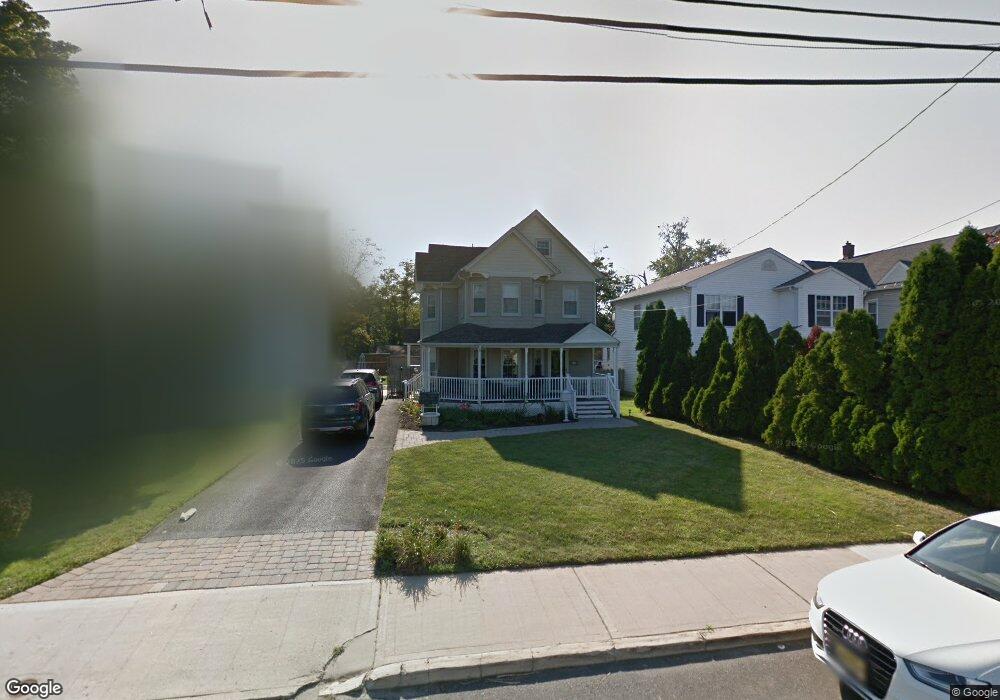
240 Liberty St Long Branch, NJ 07740
Estimated Value: $666,000 - $780,000
3
Beds
3
Baths
2,410
Sq Ft
$303/Sq Ft
Est. Value
About This Home
This home is located at 240 Liberty St, Long Branch, NJ 07740 and is currently estimated at $730,968, approximately $303 per square foot. 240 Liberty St is a home located in Monmouth County with nearby schools including Long Branch High School and Holy Trinity School.
Ownership History
Date
Name
Owned For
Owner Type
Purchase Details
Closed on
Aug 31, 2010
Sold by
Coyle Ann
Bought by
Degnan Ann C
Current Estimated Value
Home Financials for this Owner
Home Financials are based on the most recent Mortgage that was taken out on this home.
Original Mortgage
$143,000
Interest Rate
4%
Mortgage Type
New Conventional
Purchase Details
Closed on
Dec 8, 2000
Sold by
Millhurst Mills Inc
Bought by
Coyle Ann
Home Financials for this Owner
Home Financials are based on the most recent Mortgage that was taken out on this home.
Original Mortgage
$135,600
Interest Rate
7.7%
Create a Home Valuation Report for This Property
The Home Valuation Report is an in-depth analysis detailing your home's value as well as a comparison with similar homes in the area
Home Values in the Area
Average Home Value in this Area
Purchase History
| Date | Buyer | Sale Price | Title Company |
|---|---|---|---|
| Degnan Ann C | -- | None Available | |
| Coyle Ann | $169,500 | -- |
Source: Public Records
Mortgage History
| Date | Status | Borrower | Loan Amount |
|---|---|---|---|
| Closed | Degnan Ann C | $143,000 | |
| Previous Owner | Coyle Ann | $135,600 |
Source: Public Records
Tax History Compared to Growth
Tax History
| Year | Tax Paid | Tax Assessment Tax Assessment Total Assessment is a certain percentage of the fair market value that is determined by local assessors to be the total taxable value of land and additions on the property. | Land | Improvement |
|---|---|---|---|---|
| 2025 | $9,891 | $682,200 | $253,200 | $429,000 |
| 2024 | $9,467 | $643,500 | $233,200 | $410,300 |
| 2023 | $9,467 | $609,600 | $193,200 | $416,400 |
| 2022 | $8,915 | $507,000 | $140,100 | $366,900 |
| 2021 | $8,915 | $448,200 | $105,100 | $343,100 |
| 2020 | $9,054 | $433,200 | $92,100 | $341,100 |
| 2019 | $8,688 | $413,300 | $88,100 | $325,200 |
| 2018 | $8,443 | $399,400 | $86,100 | $313,300 |
| 2017 | $8,069 | $391,500 | $84,100 | $307,400 |
| 2016 | $9,030 | $446,800 | $95,100 | $351,700 |
| 2015 | $7,538 | $338,500 | $69,600 | $268,900 |
| 2014 | $7,586 | $359,000 | $87,700 | $271,300 |
Source: Public Records
Map
Nearby Homes
- 211 Rockwell Ave
- 40 University Dr
- 151 N 5th Ave
- 184 N 5th Ave
- 188 Chelton Ave
- 323 Florence Ave
- 172 Chelton Ave
- 231 Long Branch Ave
- 148 Sixth Ave
- 138 Rosewood Ave
- 190 Spruce St Unit 4
- 392 Florence Ave
- 40 Seaview Ave Unit A
- 401 Joline Ave
- 40 N 5th Ave
- 154 Atlantic Ave
- 422 Ocean Blvd N Unit 5H
- 381 Long Branch Ave
- 200 Ocean Ave N Unit 13
- 200 Ocean Ave N Unit 19
- 246 Liberty St
- 236 Liberty St
- 248 Liberty St
- 222 Hamilton Ave
- 226 Hamilton Ave
- 228 Liberty St
- 243 Liberty St
- 250 Liberty St
- 233 Liberty St
- 245 Liberty St
- 230 Hamilton Ave
- 220 Liberty St
- 220 Liberty St Unit 2
- 235 Liberty St
- 225 Joline Ave
- 239 Liberty St
- 221 Joline Ave
- 219 Hamilton Ave
- 221 Hamilton Ave
- 221 Liberty St