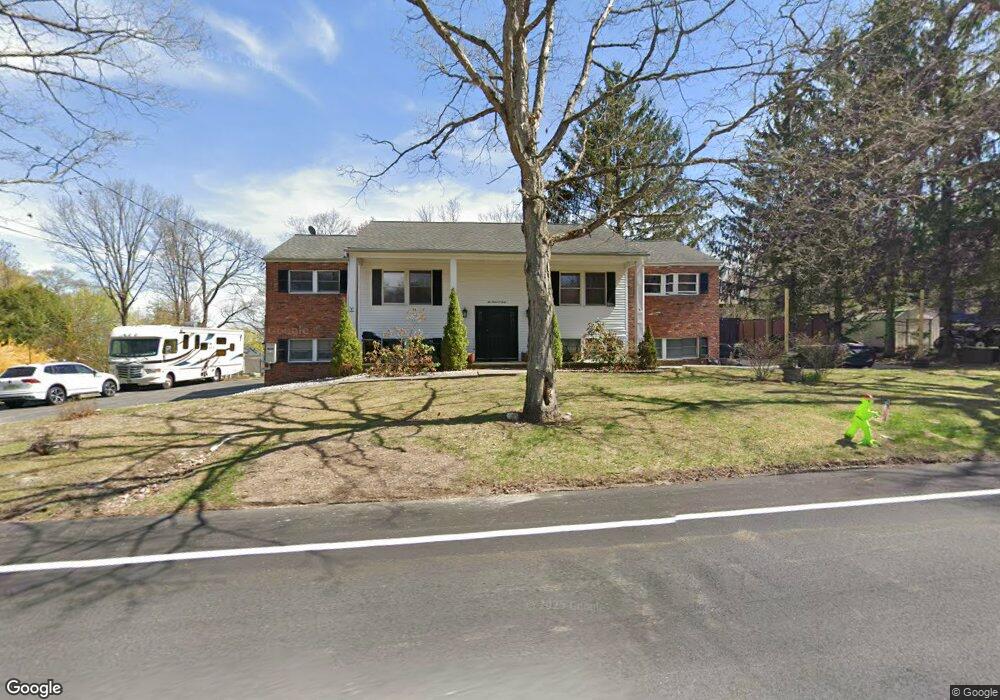
240 Maple Rd West Milford, NJ 07480
Estimated Value: $567,984 - $716,000
--
Bed
--
Bath
2,792
Sq Ft
$225/Sq Ft
Est. Value
About This Home
This home is located at 240 Maple Rd, West Milford, NJ 07480 and is currently estimated at $627,996, approximately $224 per square foot. 240 Maple Rd is a home located in Passaic County with nearby schools including Macopin Middle School and West Milford High School.
Ownership History
Date
Name
Owned For
Owner Type
Purchase Details
Closed on
Mar 23, 2023
Sold by
Hensley Sharon
Bought by
Hensley Michael Blaine and Hensley Sharon
Current Estimated Value
Purchase Details
Closed on
Feb 3, 1997
Sold by
Griffiths Leslie and Griffiths Catherine
Bought by
Hensley Sharon
Create a Home Valuation Report for This Property
The Home Valuation Report is an in-depth analysis detailing your home's value as well as a comparison with similar homes in the area
Home Values in the Area
Average Home Value in this Area
Purchase History
| Date | Buyer | Sale Price | Title Company |
|---|---|---|---|
| Hensley Michael Blaine | -- | None Listed On Document | |
| Hensley Michael Blaine | -- | None Listed On Document | |
| Hensley Sharon | -- | -- |
Source: Public Records
Tax History Compared to Growth
Tax History
| Year | Tax Paid | Tax Assessment Tax Assessment Total Assessment is a certain percentage of the fair market value that is determined by local assessors to be the total taxable value of land and additions on the property. | Land | Improvement |
|---|---|---|---|---|
| 2025 | $12,385 | $305,500 | $89,800 | $215,700 |
| 2024 | $12,449 | $305,500 | $89,800 | $215,700 |
| 2022 | $12,186 | $305,500 | $89,800 | $215,700 |
| 2021 | $11,404 | $301,300 | $89,800 | $211,500 |
| 2020 | $11,284 | $301,300 | $89,800 | $211,500 |
| 2019 | $11,133 | $301,300 | $89,800 | $211,500 |
| 2018 | $11,106 | $301,300 | $89,800 | $211,500 |
| 2017 | $11,157 | $301,300 | $89,800 | $211,500 |
| 2016 | $11,175 | $301,300 | $89,800 | $211,500 |
| 2015 | $11,046 | $301,300 | $89,800 | $211,500 |
| 2014 | $10,778 | $301,300 | $89,800 | $211,500 |
Source: Public Records
Map
Nearby Homes
- 0 Post Brook Rd Unit 25008921
- 0 Post Brook Rd Unit 3952366
- 37 Hancock Dr
- 3 Broadway
- 66 Lindys Dr
- 449 Otterhole Rd
- 54 Broadway
- 54 Nosenzo Pond Rd
- 16 Pond View Dr
- 347 Otterhole Rd
- 34 Gould Rd
- 43 Bisset Dr
- 0 Laurel Hollow
- 20 Torne Mountain Rd
- 24 E Park Dr
- 53 E Park Dr
- 00 Ferndale Rd
- 870 MacOpin Rd
- 15 Deer Path
- 17 Pheasant Ln
- 35 Cliffside Dr
- 170 Schofield Rd
- 246 Maple Rd
- 241 Maple Rd
- 234 Maple Rd
- 44 Woodside Dr
- 229 Maple Rd
- 42 Woodside Dr
- 31 Cliffside Dr
- 168 Schofield Rd
- 38 Woodside Dr
- 41 Woodside Dr
- 164 Schofield Rd
- 5 Lakeview Dr
- 47 Woodside Dr
- 37 Woodside Dr
- 34 Woodside Dr
- 25 Cliffside Dr
- 158 Schofield Rd
- 21 Spinnler Dr