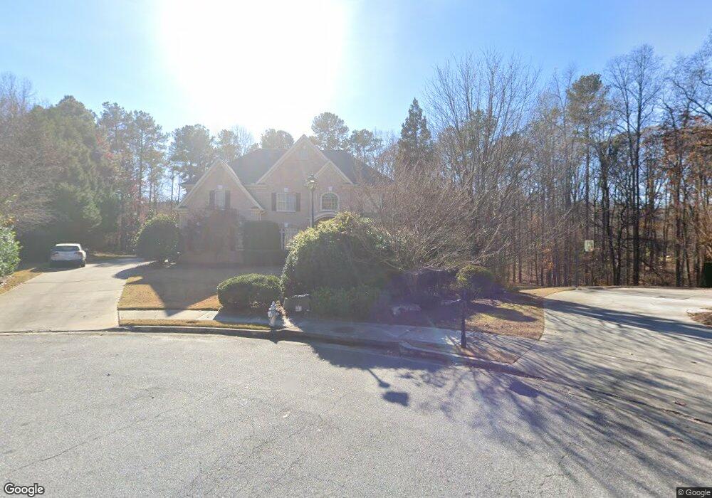
240 Sulling Way Alpharetta, GA 30009
Estimated Value: $1,546,000 - $1,786,000
5
Beds
6
Baths
5,292
Sq Ft
$314/Sq Ft
Est. Value
About This Home
This home is located at 240 Sulling Way, Alpharetta, GA 30009 and is currently estimated at $1,663,146, approximately $314 per square foot. 240 Sulling Way is a home located in Fulton County with nearby schools including Alpharetta Elementary School, Northwestern Middle School, and Milton High School.
Ownership History
Date
Name
Owned For
Owner Type
Purchase Details
Closed on
Sep 6, 2002
Sold by
Fuqua Construction Co Inc
Bought by
Hughes James B
Current Estimated Value
Home Financials for this Owner
Home Financials are based on the most recent Mortgage that was taken out on this home.
Original Mortgage
$200,000
Outstanding Balance
$83,730
Interest Rate
6.27%
Mortgage Type
New Conventional
Estimated Equity
$1,579,416
Create a Home Valuation Report for This Property
The Home Valuation Report is an in-depth analysis detailing your home's value as well as a comparison with similar homes in the area
Home Values in the Area
Average Home Value in this Area
Purchase History
| Date | Buyer | Sale Price | Title Company |
|---|---|---|---|
| Hughes James B | $691,100 | -- |
Source: Public Records
Mortgage History
| Date | Status | Borrower | Loan Amount |
|---|---|---|---|
| Open | Hughes James B | $200,000 | |
| Closed | Hughes James B | $150,000 |
Source: Public Records
Tax History Compared to Growth
Tax History
| Year | Tax Paid | Tax Assessment Tax Assessment Total Assessment is a certain percentage of the fair market value that is determined by local assessors to be the total taxable value of land and additions on the property. | Land | Improvement |
|---|---|---|---|---|
| 2025 | $2,001 | $605,600 | $160,800 | $444,800 |
| 2023 | $14,595 | $517,080 | $121,760 | $395,320 |
| 2022 | $8,850 | $420,480 | $107,960 | $312,520 |
| 2021 | $10,508 | $354,920 | $81,240 | $273,680 |
| 2020 | $10,618 | $363,840 | $53,840 | $310,000 |
| 2019 | $1,677 | $364,400 | $46,520 | $317,880 |
| 2018 | $9,519 | $355,880 | $45,440 | $310,440 |
| 2017 | $8,542 | $304,720 | $57,280 | $247,440 |
| 2016 | $8,542 | $304,720 | $57,280 | $247,440 |
| 2015 | $10,129 | $304,720 | $57,280 | $247,440 |
| 2014 | $8,396 | $286,640 | $62,200 | $224,440 |
Source: Public Records
Map
Nearby Homes
- 1580 Mayfield Rd
- 1895 Henley Way
- 4110 Providence Square
- 1645 Mayfield Rd
- 1835 Henley Way
- 165 Oakhurst Leaf Dr Unit 4
- 2100 Providence Oaks St
- 275 Heatherton Way
- 842 N Brookshade Pkwy
- 245 Heatherton Way
- 925 Pebblestone Ct
- 4016 Dover Ave
- 735 Hammock Ln
- 1050 Little River Ln
- 1360 Bethany Ct
- 406 Woodliff Place
- 14050 Providence Rd
- 175 Heatherton Ln
- 150 Cobblestone Way
- 220 Sulling Way
- 245 Sulling Way
- 380 Newcastle Dr
- 340 Newcastle Dr
- 370 Newcastle Dr
- 210 Sulling Way
- 235 Sulling Way
- 360 Newcastle Dr
- 330 Newcastle Dr
- 225 Sulling Way
- 430 Newcastle Dr
- 0 Newcastle Dr Unit 7469338
- 0 Newcastle Dr Unit 8557560
- 0 Newcastle Dr Unit 8459607
- 0 Newcastle Dr Unit 7182037
- 395 Newcastle Dr
- 180 Sulling Way
- 215 Sulling Way
- 170 Sulling Way
- 355 Newcastle Dr