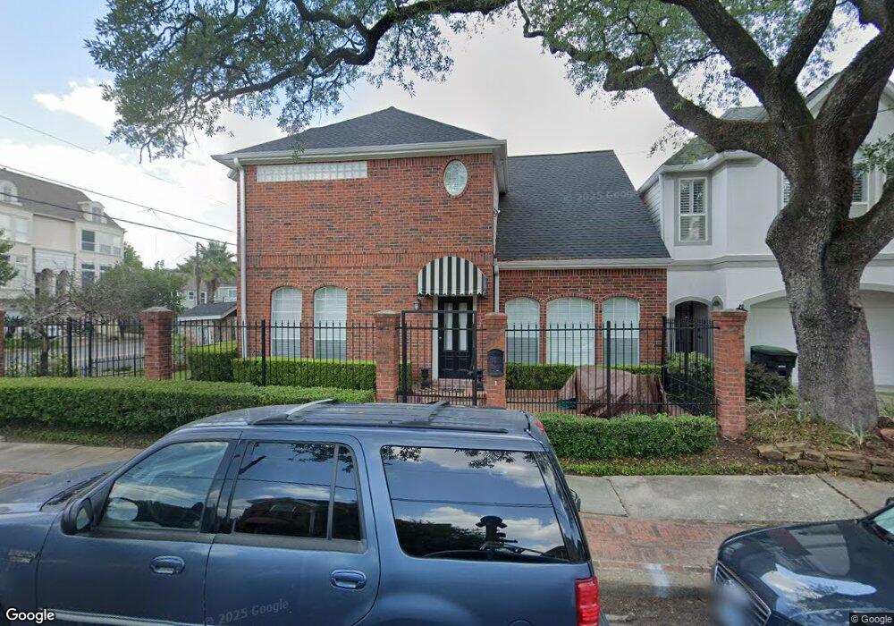
2401 Mcduffie St Houston, TX 77019
Montrose NeighborhoodEstimated Value: $540,498 - $588,000
2
Beds
3
Baths
1,865
Sq Ft
$304/Sq Ft
Est. Value
About This Home
This home is located at 2401 Mcduffie St, Houston, TX 77019 and is currently estimated at $566,125, approximately $303 per square foot. 2401 Mcduffie St is a home located in Harris County with nearby schools including Baker Montessori, Lanier Middle School, and Lamar High School.
Ownership History
Date
Name
Owned For
Owner Type
Purchase Details
Closed on
Nov 10, 1994
Sold by
Sherryes Homes Inc
Bought by
Macdonald Sheila
Current Estimated Value
Purchase Details
Closed on
Dec 16, 1993
Sold by
Moser Robert E
Bought by
Coburn John B and Coburn Sherrye S
Purchase Details
Closed on
Sep 30, 1993
Sold by
Skinner William P and Skinner Richard M
Bought by
Moser Robert E
Home Financials for this Owner
Home Financials are based on the most recent Mortgage that was taken out on this home.
Original Mortgage
$48,634
Interest Rate
6.96%
Mortgage Type
Seller Take Back
Create a Home Valuation Report for This Property
The Home Valuation Report is an in-depth analysis detailing your home's value as well as a comparison with similar homes in the area
Home Values in the Area
Average Home Value in this Area
Purchase History
| Date | Buyer | Sale Price | Title Company |
|---|---|---|---|
| Macdonald Sheila | -- | Charter Title Company | |
| Coburn John B | -- | -- | |
| Moser Robert E | -- | Heritage Title Co |
Source: Public Records
Mortgage History
| Date | Status | Borrower | Loan Amount |
|---|---|---|---|
| Previous Owner | Moser Robert E | $48,634 |
Source: Public Records
Tax History Compared to Growth
Tax History
| Year | Tax Paid | Tax Assessment Tax Assessment Total Assessment is a certain percentage of the fair market value that is determined by local assessors to be the total taxable value of land and additions on the property. | Land | Improvement |
|---|---|---|---|---|
| 2025 | $4,145 | $559,106 | $288,750 | $270,356 |
| 2024 | $4,145 | $564,238 | $288,750 | $275,488 |
| 2023 | $4,145 | $564,238 | $288,750 | $275,488 |
| 2022 | $5,813 | $522,268 | $288,750 | $233,518 |
| 2021 | $11,659 | $494,796 | $275,625 | $219,171 |
| 2020 | $10,697 | $491,774 | $275,625 | $216,149 |
| 2019 | $10,162 | $401,597 | $155,000 | $246,597 |
| 2018 | $8,805 | $447,641 | $155,000 | $292,641 |
| 2017 | $11,878 | $447,641 | $155,000 | $292,641 |
| 2016 | $11,701 | $447,641 | $155,000 | $292,641 |
| 2015 | $7,354 | $447,641 | $155,000 | $292,641 |
| 2014 | $7,354 | $404,438 | $135,625 | $268,813 |
Source: Public Records
Map
Nearby Homes
- 2505 Mcduffie St Unit B
- 2309 Driscoll St
- 2508 Brun St
- 2315 Huldy St
- 2112 Mcduffie St
- 2410 Huldy St
- 2103 Hazard St
- 2119 Huldy St
- 2117 Huldy St
- 1900 Hawthorne St
- 2115 Huldy St
- 2113 Huldy St
- 2026 Morse St
- 2027 Huldy St
- 2008 Hazard St
- 2415 Elmen St
- 2314 Park St
- 2003 Morse St
- 1912 Kipling St
- 1924 Kipling St
- 2405 Mcduffie St
- 1985 Fairview St
- 2407 Mcduffie St
- 1977 Fairview St Unit 1
- 1977 Fairview St Unit B
- 2411 Mcduffie St
- 2418 Hazard St Unit A
- 2418 Hazard St Unit 3
- 2418 Hazard St Unit B
- 2402 Hazard St
- 2323 Mcduffie St
- 1980 Fairview St
- 2404 Hazard St
- 1978 Fairview Ave
- 2007 Fairview St
- 1978 Fairview St
- 2406 Hazard St
- 1976 Fairview St
- 2406 Mcduffie St
- 1972 Fairview St Unit D