Estimated Value: $564,000 - $628,000
3
Beds
3
Baths
2,298
Sq Ft
$258/Sq Ft
Est. Value
About This Home
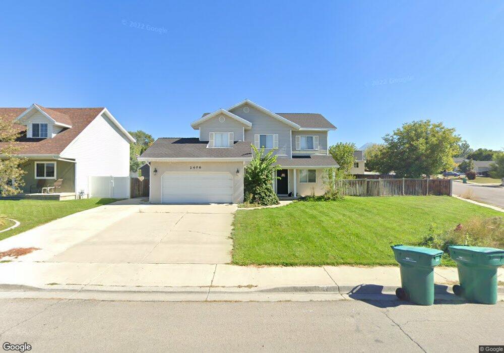
This home is located at 2406 Sunset Dr, Lehi, UT 84043 and is currently estimated at $592,284, approximately $257 per square foot. 2406 Sunset Dr is a home located in Utah County with nearby schools including Fox Hollow Elementary School, Skyridge High School, and Ignite Entrepreneurship Academy.
Ownership History
Date
Name
Owned For
Owner Type
Purchase Details
Closed on
Nov 18, 2020
Sold by
Stevens Brett
Bought by
Stevens Brent and Stevens Ricky L
Current Estimated Value
Home Financials for this Owner
Home Financials are based on the most recent Mortgage that was taken out on this home.
Original Mortgage
$239,000
Outstanding Balance
$212,676
Interest Rate
2.8%
Mortgage Type
New Conventional
Estimated Equity
$379,608
Purchase Details
Closed on
Jun 4, 2013
Sold by
Brown Nathan L and Brown Britt
Bought by
Stevens Brett
Home Financials for this Owner
Home Financials are based on the most recent Mortgage that was taken out on this home.
Original Mortgage
$233,689
Interest Rate
3.5%
Mortgage Type
FHA
Purchase Details
Closed on
Jan 30, 2007
Sold by
Brown Nathan L and Brown Britt
Bought by
Brown Nathan L and Brown Britt
Purchase Details
Closed on
Nov 19, 2002
Sold by
Brown Nathan L
Bought by
Brown Nathan and Brown Nathan L
Home Financials for this Owner
Home Financials are based on the most recent Mortgage that was taken out on this home.
Original Mortgage
$149,600
Interest Rate
6.12%
Purchase Details
Closed on
Dec 27, 2001
Sold by
State Street Bank & Trust Company
Bought by
Brown Nathan L
Home Financials for this Owner
Home Financials are based on the most recent Mortgage that was taken out on this home.
Original Mortgage
$117,600
Interest Rate
8.12%
Purchase Details
Closed on
Aug 10, 2001
Sold by
Stone Joseph L and Stone Darla D
Bought by
Bank & Trust Company
Purchase Details
Closed on
Jul 26, 1999
Sold by
Stone Joseph L
Bought by
Stone Joseph L and Stone Darla D
Home Financials for this Owner
Home Financials are based on the most recent Mortgage that was taken out on this home.
Original Mortgage
$163,800
Interest Rate
7.7%
Purchase Details
Closed on
Jul 16, 1999
Sold by
Morrison Dan
Bought by
Stone Joseph L
Home Financials for this Owner
Home Financials are based on the most recent Mortgage that was taken out on this home.
Original Mortgage
$163,800
Interest Rate
7.7%
Create a Home Valuation Report for This Property
The Home Valuation Report is an in-depth analysis detailing your home's value as well as a comparison with similar homes in the area
Home Values in the Area
Average Home Value in this Area
Purchase History
| Date | Buyer | Sale Price | Title Company |
|---|---|---|---|
| Stevens Brent | -- | Accommodation | |
| Stevens Brett | -- | Union Title | |
| Brown Nathan L | -- | First American | |
| Brown Nathan | -- | First American Title Co | |
| Brown Nathan L | -- | Surety Title Corporation | |
| Bank & Trust Company | $153,000 | Backman Stewart Title Servi | |
| Stone Joseph L | -- | -- | |
| Stone Joseph L | -- | -- |
Source: Public Records
Mortgage History
| Date | Status | Borrower | Loan Amount |
|---|---|---|---|
| Open | Stevens Brent | $239,000 | |
| Closed | Stevens Brett | $233,689 | |
| Previous Owner | Brown Nathan | $149,600 | |
| Previous Owner | Brown Nathan L | $117,600 | |
| Previous Owner | Stone Joseph L | $163,800 | |
| Closed | Brown Nathan L | $29,400 |
Source: Public Records
Tax History
| Year | Tax Paid | Tax Assessment Tax Assessment Total Assessment is a certain percentage of the fair market value that is determined by local assessors to be the total taxable value of land and additions on the property. | Land | Improvement |
|---|---|---|---|---|
| 2025 | $2,311 | $286,770 | -- | -- |
| 2024 | $2,311 | $270,435 | $0 | $0 |
| 2023 | $2,205 | $280,225 | $0 | $0 |
| 2022 | $2,289 | $281,930 | $0 | $0 |
| 2021 | $2,062 | $384,100 | $110,800 | $273,300 |
| 2020 | $1,945 | $358,000 | $102,600 | $255,400 |
| 2019 | $1,823 | $348,800 | $102,600 | $246,200 |
| 2018 | $1,722 | $311,600 | $93,600 | $218,000 |
| 2017 | $1,619 | $155,760 | $0 | $0 |
| 2016 | $1,630 | $145,475 | $0 | $0 |
| 2015 | $1,691 | $143,220 | $0 | $0 |
| 2014 | $1,503 | $126,610 | $0 | $0 |
Source: Public Records
Map
Nearby Homes
- 2600 N 1200 W Unit 6
- 2764 N 990 W
- 862 W 2750 N
- 755 W 2180 N
- 548 W 2325 N
- 516 W 2280 N
- 2908 N 1080 W
- 1194 W 2900 N
- 1155 W 2980 N
- 442 W 2540 N
- 1127 W State St
- 1179 W 2980 N
- 1195 W 2980 N
- 1940 N 900 W
- 497 W 2200 N
- 2918 N 1310 W Unit D
- 2712 N Park View Ct
- 1340 W 2910 N Unit EE3
- 398 W 2660 N
- 1441 W Westbury #G Way N Unit 2
Your Personal Tour Guide
Ask me questions while you tour the home.