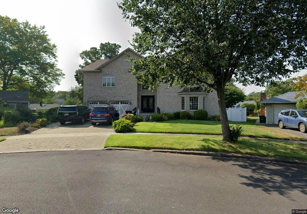
241 Beech Ct River Edge, NJ 07661
Estimated Value: $1,056,000 - $1,756,000
--
Bed
--
Bath
5,000
Sq Ft
$277/Sq Ft
Est. Value
About This Home
This home is located at 241 Beech Ct, River Edge, NJ 07661 and is currently estimated at $1,387,342, approximately $277 per square foot. 241 Beech Ct is a home located in Bergen County with nearby schools including Cherry Hill School, River Dell Middle School, and River Dell Regional High School.
Ownership History
Date
Name
Owned For
Owner Type
Purchase Details
Closed on
Jul 10, 2019
Sold by
Bank Of America Na Tr
Bought by
183 Concord Drive Llc
Current Estimated Value
Purchase Details
Closed on
Aug 31, 2007
Sold by
Michael David
Bought by
Michael Adel
Purchase Details
Closed on
Jul 25, 2005
Sold by
Gutin Glenn
Bought by
Michael Adel
Home Financials for this Owner
Home Financials are based on the most recent Mortgage that was taken out on this home.
Original Mortgage
$330,000
Interest Rate
5.63%
Purchase Details
Closed on
Jan 22, 1996
Sold by
Noonan Paul
Bought by
Gutin Glnn and Gutin Laura
Home Financials for this Owner
Home Financials are based on the most recent Mortgage that was taken out on this home.
Original Mortgage
$184,000
Interest Rate
7.16%
Create a Home Valuation Report for This Property
The Home Valuation Report is an in-depth analysis detailing your home's value as well as a comparison with similar homes in the area
Home Values in the Area
Average Home Value in this Area
Purchase History
| Date | Buyer | Sale Price | Title Company |
|---|---|---|---|
| 183 Concord Drive Llc | $422,777 | -- | |
| Michael Adel | -- | Lawyers Title | |
| Michael David | -- | -- | |
| Michael Adel | $4,250,000 | -- | |
| Gutin Glnn | $230,000 | -- |
Source: Public Records
Mortgage History
| Date | Status | Borrower | Loan Amount |
|---|---|---|---|
| Previous Owner | Michael Adel | $330,000 | |
| Previous Owner | Gutin Glnn | $184,000 |
Source: Public Records
Tax History Compared to Growth
Tax History
| Year | Tax Paid | Tax Assessment Tax Assessment Total Assessment is a certain percentage of the fair market value that is determined by local assessors to be the total taxable value of land and additions on the property. | Land | Improvement |
|---|---|---|---|---|
| 2025 | $33,703 | $1,452,100 | $361,900 | $1,090,200 |
| 2024 | $32,861 | $850,000 | $208,000 | $642,000 |
| 2023 | $31,450 | $850,000 | $208,000 | $642,000 |
| 2022 | $31,450 | $850,000 | $208,000 | $642,000 |
| 2021 | $30,830 | $850,000 | $208,000 | $642,000 |
| 2020 | $30,345 | $850,000 | $208,000 | $642,000 |
| 2019 | $29,478 | $850,000 | $208,000 | $642,000 |
| 2018 | $28,858 | $850,000 | $208,000 | $642,000 |
| 2017 | $28,577 | $850,000 | $208,000 | $642,000 |
| 2016 | $27,931 | $850,000 | $208,000 | $642,000 |
| 2015 | $27,345 | $850,000 | $208,000 | $642,000 |
| 2014 | $29,526 | $916,100 | $208,000 | $708,100 |
Source: Public Records
Map
Nearby Homes
- 302 Howland Ave
- 215 Kensington Rd
- 81 Eastbrook Dr
- 212 Lozier Terrace
- 421 Lafayette Ave
- 42 Eastbrook Dr
- 122 Village Cir E
- 192 Valley Rd
- 168 Voorhis Ave
- 150 Village Cir E
- 12 Gainesborough Terrace Unit 1B
- 16 Coles Ct
- 165 Mohawk Dr
- 293 Bogert Rd Unit 1A
- 1 Sipporta Ln
- 189 Forest Ave Unit 409
- 189 Forest Ave Unit 303
- 222 Zabriskie Place
- 214 Zabriskie Place
- 276 Greenway Terrace