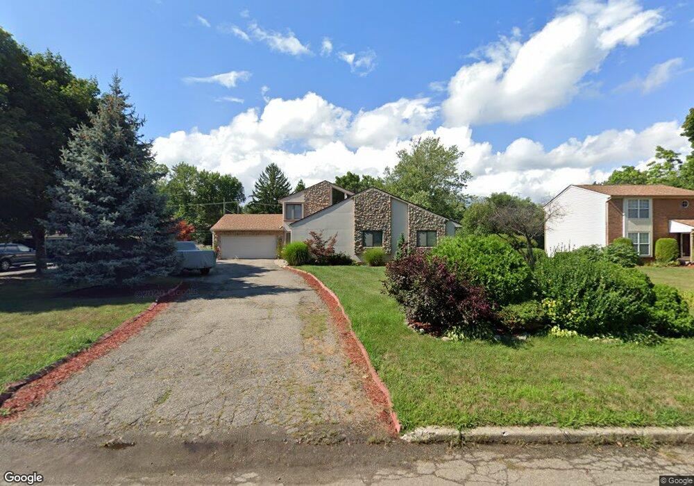
241 Bloomfield Blvd Bloomfield Hills, MI 48302
Estimated Value: $433,000 - $502,000
4
Beds
3
Baths
2,463
Sq Ft
$188/Sq Ft
Est. Value
About This Home
This home is located at 241 Bloomfield Blvd, Bloomfield Hills, MI 48302 and is currently estimated at $462,117, approximately $187 per square foot. 241 Bloomfield Blvd is a home located in Oakland County with nearby schools including Eastover Elementary School, Bloomfield Hills High School, and Arts & Technology Academy of Pontiac.
Ownership History
Date
Name
Owned For
Owner Type
Purchase Details
Closed on
Apr 12, 2024
Sold by
Sanders Geraldine B
Bought by
Sanders Geraldine B and Geraldine B Sanders Revocable Living Trust
Current Estimated Value
Purchase Details
Closed on
Apr 15, 2016
Sold by
Sanders Geraldine and Sanders Frederick
Bought by
Sanders Geraldine
Create a Home Valuation Report for This Property
The Home Valuation Report is an in-depth analysis detailing your home's value as well as a comparison with similar homes in the area
Home Values in the Area
Average Home Value in this Area
Purchase History
| Date | Buyer | Sale Price | Title Company |
|---|---|---|---|
| Sanders Geraldine B | -- | None Listed On Document | |
| Sanders Geraldine | -- | None Available |
Source: Public Records
Tax History Compared to Growth
Tax History
| Year | Tax Paid | Tax Assessment Tax Assessment Total Assessment is a certain percentage of the fair market value that is determined by local assessors to be the total taxable value of land and additions on the property. | Land | Improvement |
|---|---|---|---|---|
| 2024 | $1,697 | $236,620 | $0 | $0 |
| 2023 | $1,642 | $193,060 | $0 | $0 |
| 2022 | $3,087 | $176,810 | $0 | $0 |
| 2021 | $3,064 | $122,700 | $0 | $0 |
| 2020 | $1,502 | $125,560 | $0 | $0 |
| 2019 | $2,884 | $138,610 | $0 | $0 |
| 2018 | $2,897 | $128,270 | $0 | $0 |
| 2017 | $2,876 | $125,950 | $0 | $0 |
| 2016 | $2,882 | $125,170 | $0 | $0 |
| 2015 | -- | $123,120 | $0 | $0 |
| 2014 | -- | $101,450 | $0 | $0 |
| 2011 | -- | $67,510 | $0 | $0 |
Source: Public Records
Map
Nearby Homes
- 00 S Berkshire
- 95 Hillsdale Rd
- 200 Cedardale Ave
- 583 Going St
- 200 Astorwood St
- 323 Ferry Ave
- 2449 Mulberry Square Unit 31
- 2383 Mulberry Square Unit 72
- 2449 Mulberry Square Unit 28
- 465 S Marshall St
- 2442 Mulberry Square Unit 36
- 447 S Marshall St
- 440 Martin Luther King Junior Blvd S
- 2665 Lahser Rd
- 567 Highland Ave
- 209 Ferry Ave
- 317 Prospect St
- 363 Sycamore Ct
- 371 Nebraska Ave
- 472 S Jessie St
- 255 Bloomfield Blvd
- 225 Bloomfield Blvd
- 254 Alice Ave
- 250 Alice Ave
- 284 Alice Ave
- 209 Bloomfield Blvd
- 271 Bloomfield Blvd
- 300 Alica
- 230 Alice Ave
- 300 Alice Ave
- 240 Bloomfield Blvd
- 224 Bloomfield Blvd
- 255 Alice Ave
- 263 Alice Ave
- 181 Bloomfield Blvd
- 256 Bloomfield Blvd
- 249 Alice Ave
- 277 Alice Ave
- 289 Alice Ave
- 208 Bloomfield Blvd