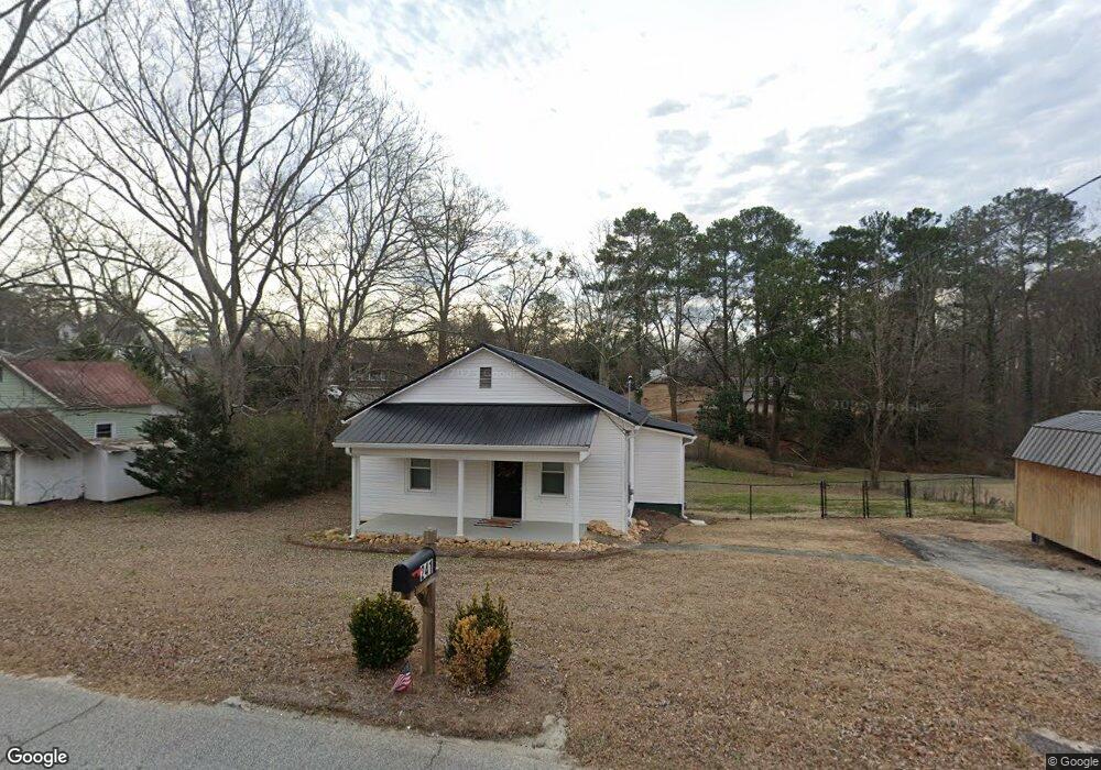
241 Foster Ave W Dallas, GA 30132
Estimated Value: $106,000 - $211,000
1
Bed
1
Bath
800
Sq Ft
$197/Sq Ft
Est. Value
About This Home
This home is located at 241 Foster Ave W, Dallas, GA 30132 and is currently estimated at $157,510, approximately $196 per square foot. 241 Foster Ave W is a home located in Paulding County with nearby schools including Dallas Elementary School, Herschel Jones Middle School, and Paulding County High School.
Ownership History
Date
Name
Owned For
Owner Type
Purchase Details
Closed on
Mar 4, 2022
Sold by
Headrick Properties Llc
Bought by
Callaway Patrick
Current Estimated Value
Purchase Details
Closed on
Mar 18, 2021
Sold by
Carruth Timothy H
Bought by
Headrick Properties Llc
Purchase Details
Closed on
Mar 25, 1994
Sold by
Hud
Bought by
Shearin J N and Carrul Timothy H
Purchase Details
Closed on
Jul 6, 1993
Sold by
Digue Cindy K
Bought by
Independence One Mtg
Create a Home Valuation Report for This Property
The Home Valuation Report is an in-depth analysis detailing your home's value as well as a comparison with similar homes in the area
Home Values in the Area
Average Home Value in this Area
Purchase History
| Date | Buyer | Sale Price | Title Company |
|---|---|---|---|
| Callaway Patrick | $130,000 | -- | |
| Headrick Properties Llc | $70,000 | -- | |
| Shearin J N | -- | -- | |
| Independence One Mtg | $42,400 | -- |
Source: Public Records
Tax History Compared to Growth
Tax History
| Year | Tax Paid | Tax Assessment Tax Assessment Total Assessment is a certain percentage of the fair market value that is determined by local assessors to be the total taxable value of land and additions on the property. | Land | Improvement |
|---|---|---|---|---|
| 2024 | $1,384 | $44,352 | $4,160 | $40,192 |
| 2023 | $1,281 | $42,348 | $4,000 | $38,348 |
| 2022 | $730 | $35,872 | $3,680 | $32,192 |
| 2021 | $787 | $27,068 | $3,360 | $23,708 |
| 2020 | $841 | $24,824 | $3,480 | $21,344 |
| 2019 | $816 | $23,780 | $5,840 | $17,940 |
| 2018 | $572 | $18,980 | $7,040 | $11,940 |
| 2017 | $621 | $17,900 | $7,040 | $10,860 |
| 2016 | $559 | $16,260 | $7,040 | $9,220 |
| 2015 | $473 | $15,380 | $7,040 | $8,340 |
| 2014 | $451 | $14,300 | $7,040 | $7,260 |
| 2013 | -- | $11,840 | $6,560 | $5,280 |
Source: Public Records
Map
Nearby Homes
- 216 Hardee St
- 208 Park St Unit 114
- 199 Highland Ave
- 353 Spring Ridge Path
- 0 Merchants Dr Unit 7658248
- 0 Merchants Dr Unit 10615716
- 217 Victory Dr
- 234 E Memorial Dr
- 157 Hampton Dr
- 193 Hampton Dr
- 156 Hampton Dr
- 176 Hampton Dr
- 211 Hampton Dr
- 0 Jimmy Campbell Pkwy Unit 10556704
- 0 Jimmy Campbell Pkwy Unit 7607737
- 250 E Memorial Dr
- 207 Confederate Ave
- 201 Oak View Ln
- 210 N Johnston St
- 245 Foster Ave W
- 245 W Foster Ave
- 497 Hardee St
- 206 Foster Ave W
- 227 Foster Ave W
- 489 Hardee St
- 313 Hardee St
- 499 Hardee St
- 309 Hardee St
- 101 Highland Ave
- 495 Hardee St
- 501 Hardee St
- 201 Foster Ave W
- 103 Highland Ave
- 0 W Foster Ave Unit 8481906
- W W Foster Ave
- 109 Highland Ave
- 0 Main St Unit 8264863
- 0 Main St Unit 8100540
- 0 Main St Unit 3109359