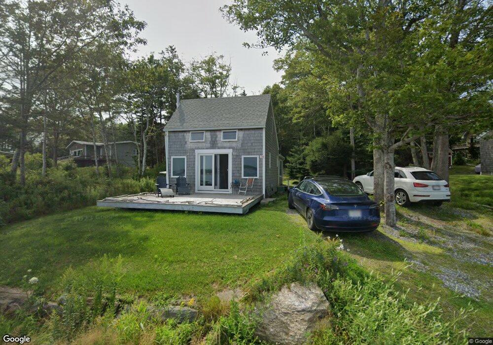
241 King Phillips Trail East Boothbay, ME 04544
Estimated Value: $472,000 - $580,000
2
Beds
1
Bath
748
Sq Ft
$726/Sq Ft
Est. Value
About This Home
This home is located at 241 King Phillips Trail, East Boothbay, ME 04544 and is currently estimated at $543,344, approximately $726 per square foot. 241 King Phillips Trail is a home located in Lincoln County with nearby schools including Boothbay Region Elementary School and Boothbay Region High School.
Ownership History
Date
Name
Owned For
Owner Type
Purchase Details
Closed on
Jul 20, 2020
Sold by
Glaesner Holdings
Bought by
Caralis Lara G and Caralis Archie J
Current Estimated Value
Home Financials for this Owner
Home Financials are based on the most recent Mortgage that was taken out on this home.
Original Mortgage
$127,000
Outstanding Balance
$111,758
Interest Rate
2.7%
Mortgage Type
New Conventional
Estimated Equity
$431,586
Create a Home Valuation Report for This Property
The Home Valuation Report is an in-depth analysis detailing your home's value as well as a comparison with similar homes in the area
Home Values in the Area
Average Home Value in this Area
Purchase History
| Date | Buyer | Sale Price | Title Company |
|---|---|---|---|
| Caralis Lara G | -- | None Available |
Source: Public Records
Mortgage History
| Date | Status | Borrower | Loan Amount |
|---|---|---|---|
| Open | Caralis Lara G | $127,000 |
Source: Public Records
Tax History Compared to Growth
Tax History
| Year | Tax Paid | Tax Assessment Tax Assessment Total Assessment is a certain percentage of the fair market value that is determined by local assessors to be the total taxable value of land and additions on the property. | Land | Improvement |
|---|---|---|---|---|
| 2024 | $2,956 | $260,458 | $186,700 | $73,758 |
| 2023 | $2,618 | $260,458 | $186,700 | $73,758 |
| 2022 | $2,422 | $260,458 | $186,700 | $73,758 |
| 2021 | $2,487 | $260,458 | $186,700 | $73,758 |
| 2020 | $2,500 | $260,458 | $186,700 | $73,758 |
| 2019 | $2,461 | $260,458 | $186,700 | $73,758 |
| 2018 | $2,422 | $260,458 | $186,700 | $73,758 |
| 2017 | $2,481 | $269,700 | $217,000 | $52,700 |
| 2016 | $2,373 | $269,700 | $217,000 | $52,700 |
| 2015 | $2,351 | $268,700 | $217,000 | $51,700 |
| 2014 | $2,899 | $341,100 | $289,400 | $51,700 |
Source: Public Records
Map
Nearby Homes
- 44 King Phillips Trail
- 12 Westwind Dr
- Lts 23A&24 Birch Island
- Birch Island
- 127 Appalachee Rd
- 5 Massachusetts Ave
- 239 Ocean Point Rd
- 74 & 76 Bay St
- 31 Bay St
- 210 Ocean Point Rd
- 58 Roads End Rd
- 19 Hill Rd
- 23 Meadow Cove Rd
- 35 Rice Rd
- 27 Townsend Ave
- 37 Townsend Ave
- 53 Commercial St
- 34 Townsend Ave
- 28 & 31 Will Alley Rd
- 66 Townsend Ave
- 239 King Phillips Trail
- 239 King Philips Trail
- 249 King Phillips Trail
- 235 King Phillips Trail
- 231 King Phillips Trail
- 257 King Phillips Trail
- 229 King Phillips Trail
- 19 Wigwam Trail
- 223 King Phillips Trail
- 229 King Philips Trail
- 13 Wigwam Trail
- 261 King Phillips Trail
- 227 King Phillips Trail
- 4 Merton Way
- 219 King Phillips Trail
- 3 Merton Way
- 215 King Phillips Trail
- 297 King Phillips Trail
- 00 Wigwam Trail
- 291 King Phillips Trail