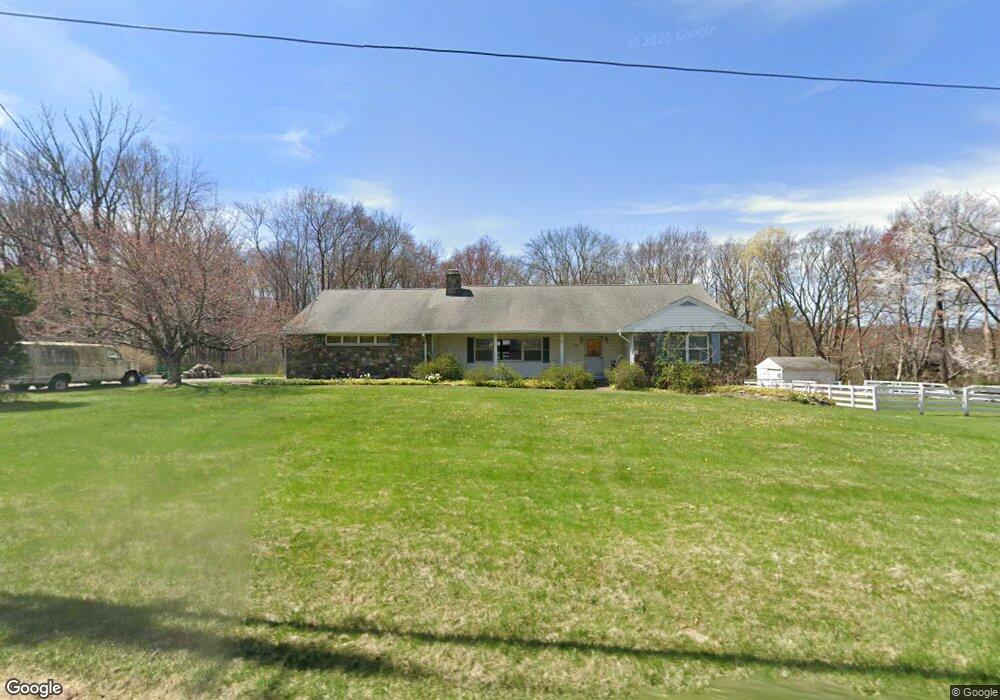
241 Maple Rd West Milford, NJ 07480
Estimated Value: $480,000 - $602,000
--
Bed
--
Bath
2,035
Sq Ft
$271/Sq Ft
Est. Value
About This Home
This home is located at 241 Maple Rd, West Milford, NJ 07480 and is currently estimated at $550,532, approximately $270 per square foot. 241 Maple Rd is a home located in Passaic County with nearby schools including Macopin Middle School and West Milford High School.
Ownership History
Date
Name
Owned For
Owner Type
Purchase Details
Closed on
Oct 31, 2023
Sold by
Cancelosi Kathleen A
Bought by
Cancelosi Family Trust and Cancelosi
Current Estimated Value
Purchase Details
Closed on
Jan 17, 2019
Sold by
Tully Donna
Bought by
Cancelosi Kathleen A
Purchase Details
Closed on
Aug 7, 2010
Sold by
Cancelosi Kathleen A and Schulz Gerard
Bought by
Cancelosi Kathleen and Schulz Gerard
Purchase Details
Closed on
Jul 20, 1995
Sold by
Higberg Laverne and Higberg Linda
Bought by
Schulz Otto
Create a Home Valuation Report for This Property
The Home Valuation Report is an in-depth analysis detailing your home's value as well as a comparison with similar homes in the area
Home Values in the Area
Average Home Value in this Area
Purchase History
| Date | Buyer | Sale Price | Title Company |
|---|---|---|---|
| Cancelosi Family Trust | -- | None Listed On Document | |
| Cancelosi Family Trust | -- | None Listed On Document | |
| Cancelosi Kathleen A | -- | None Available | |
| Cancelosi Kathleen | -- | -- | |
| Schulz Otto | $235,500 | -- |
Source: Public Records
Tax History Compared to Growth
Tax History
| Year | Tax Paid | Tax Assessment Tax Assessment Total Assessment is a certain percentage of the fair market value that is determined by local assessors to be the total taxable value of land and additions on the property. | Land | Improvement |
|---|---|---|---|---|
| 2025 | $11,765 | $290,200 | $112,800 | $177,400 |
| 2024 | $11,826 | $290,200 | $112,800 | $177,400 |
| 2022 | $11,225 | $290,200 | $112,800 | $177,400 |
| 2021 | $10,984 | $290,200 | $112,800 | $177,400 |
| 2020 | $10,868 | $290,200 | $112,800 | $177,400 |
| 2019 | $10,723 | $290,200 | $112,800 | $177,400 |
| 2018 | $10,697 | $290,200 | $112,800 | $177,400 |
| 2017 | $10,746 | $290,200 | $112,800 | $177,400 |
| 2016 | $10,764 | $290,200 | $112,800 | $177,400 |
| 2015 | $10,639 | $290,200 | $112,800 | $177,400 |
| 2014 | $10,380 | $290,200 | $112,800 | $177,400 |
Source: Public Records
Map
Nearby Homes
- 0 Post Brook Rd Unit 25008921
- 0 Post Brook Rd Unit 3952366
- 37 Hancock Dr
- 3 Broadway
- 66 Lindys Dr
- 54 Broadway
- 449 Otterhole Rd
- 54 Nosenzo Pond Rd
- 16 Pond View Dr
- 347 Otterhole Rd
- 34 Gould Rd
- 43 Bisset Dr
- 0 Laurel Hollow
- 20 Torne Mountain Rd
- 24 E Park Dr
- 53 E Park Dr
- 00 Ferndale Rd
- 870 MacOpin Rd
- 174 Kitchell Lake Dr
- 15 Deer Path