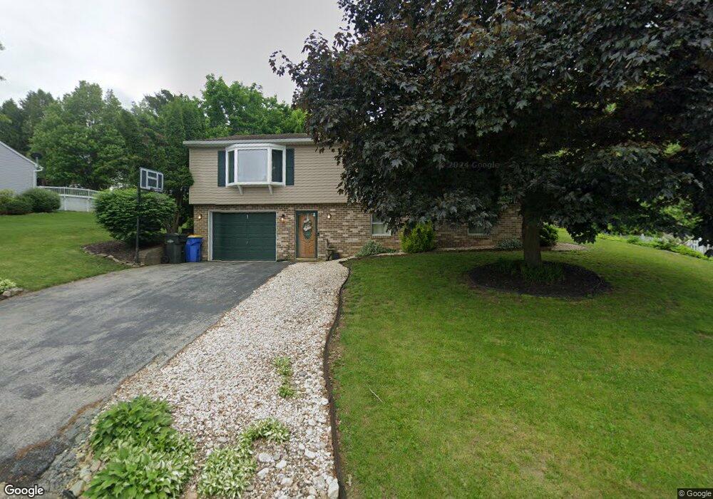
241 Troy Rd Dallastown, PA 17313
Estimated Value: $290,293 - $378,000
3
Beds
2
Baths
2,038
Sq Ft
$166/Sq Ft
Est. Value
About This Home
This home is located at 241 Troy Rd, Dallastown, PA 17313 and is currently estimated at $337,823, approximately $165 per square foot. 241 Troy Rd is a home located in York County with nearby schools including York Township Elementary School, Dallastown Area Middle School, and Dallastown Area High School.
Ownership History
Date
Name
Owned For
Owner Type
Purchase Details
Closed on
Mar 19, 2009
Sold by
Mundis Larry L and Mundis Heather L
Bought by
Mundis Heather L
Current Estimated Value
Home Financials for this Owner
Home Financials are based on the most recent Mortgage that was taken out on this home.
Original Mortgage
$30,000
Outstanding Balance
$23,905
Interest Rate
4.92%
Mortgage Type
Credit Line Revolving
Estimated Equity
$313,918
Purchase Details
Closed on
Feb 20, 2004
Sold by
Beatty Robert J and Beatty Cynthia L
Bought by
Mundis Larry L and Mundis Heather L
Home Financials for this Owner
Home Financials are based on the most recent Mortgage that was taken out on this home.
Original Mortgage
$140,887
Interest Rate
5.83%
Mortgage Type
FHA
Create a Home Valuation Report for This Property
The Home Valuation Report is an in-depth analysis detailing your home's value as well as a comparison with similar homes in the area
Home Values in the Area
Average Home Value in this Area
Purchase History
| Date | Buyer | Sale Price | Title Company |
|---|---|---|---|
| Mundis Heather L | -- | None Available | |
| Mundis Larry L | $142,000 | -- |
Source: Public Records
Mortgage History
| Date | Status | Borrower | Loan Amount |
|---|---|---|---|
| Open | Mundis Heather L | $30,000 | |
| Open | Mundis Heather L | $126,500 | |
| Closed | Mundis Larry L | $140,887 |
Source: Public Records
Tax History
| Year | Tax Paid | Tax Assessment Tax Assessment Total Assessment is a certain percentage of the fair market value that is determined by local assessors to be the total taxable value of land and additions on the property. | Land | Improvement |
|---|---|---|---|---|
| 2025 | $4,837 | $140,900 | $38,100 | $102,800 |
| 2024 | $4,766 | $140,900 | $38,100 | $102,800 |
| 2023 | $4,766 | $140,900 | $38,100 | $102,800 |
| 2022 | $4,610 | $140,900 | $38,100 | $102,800 |
| 2021 | $4,392 | $140,900 | $38,100 | $102,800 |
| 2020 | $4,392 | $140,900 | $38,100 | $102,800 |
| 2019 | $4,378 | $140,900 | $38,100 | $102,800 |
| 2018 | $4,348 | $140,900 | $38,100 | $102,800 |
| 2017 | $4,175 | $140,900 | $38,100 | $102,800 |
| 2016 | $0 | $140,900 | $38,100 | $102,800 |
| 2015 | -- | $140,900 | $38,100 | $102,800 |
| 2014 | -- | $140,900 | $38,100 | $102,800 |
Source: Public Records
Map
Nearby Homes
- 479 Frederick Dr
- 205 Teila Dr
- 113 Brant Dr
- 314 S Pleasant Ave
- 100 Clover Hill Rd
- 2881 Sunset Dr
- 686 Cortland Dr
- 356 E Main St
- 695 Oak Rd
- 197 S Main St
- 39 W George St
- 741 Aldinger Dr
- 414 S Park St
- 150 Yoe Dr
- 2723 S Queen St
- 786 Arbor Dr
- 129 Heather Glen Dr Unit 78
- 127 Heather Glen Dr Unit 80
- 510 Katonah Dr Unit 6
- 287 Chestnut Hill Rd
Your Personal Tour Guide
Ask me questions while you tour the home.