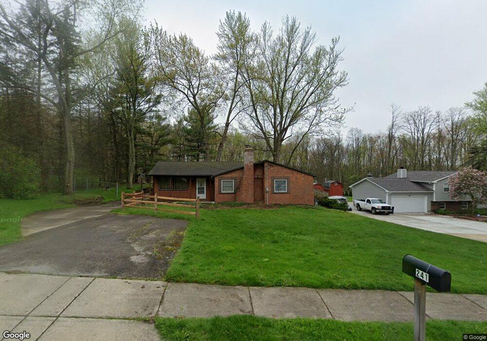
241 W Howe Rd Tallmadge, OH 44278
Estimated Value: $222,000 - $249,000
3
Beds
1
Bath
1,284
Sq Ft
$181/Sq Ft
Est. Value
About This Home
This home is located at 241 W Howe Rd, Tallmadge, OH 44278 and is currently estimated at $232,749, approximately $181 per square foot. 241 W Howe Rd is a home located in Summit County with nearby schools including Tallmadge Middle School, Tallmadge High School, and Steel Academy.
Ownership History
Date
Name
Owned For
Owner Type
Purchase Details
Closed on
Mar 1, 1999
Sold by
Wagner Joseph P and Wagner Maurina S
Bought by
Mullens Kevin W
Current Estimated Value
Home Financials for this Owner
Home Financials are based on the most recent Mortgage that was taken out on this home.
Original Mortgage
$118,126
Outstanding Balance
$29,004
Interest Rate
6.92%
Mortgage Type
FHA
Estimated Equity
$203,745
Create a Home Valuation Report for This Property
The Home Valuation Report is an in-depth analysis detailing your home's value as well as a comparison with similar homes in the area
Home Values in the Area
Average Home Value in this Area
Purchase History
| Date | Buyer | Sale Price | Title Company |
|---|---|---|---|
| Mullens Kevin W | $119,100 | Midland Commerce Group |
Source: Public Records
Mortgage History
| Date | Status | Borrower | Loan Amount |
|---|---|---|---|
| Open | Mullens Kevin W | $118,126 |
Source: Public Records
Tax History Compared to Growth
Tax History
| Year | Tax Paid | Tax Assessment Tax Assessment Total Assessment is a certain percentage of the fair market value that is determined by local assessors to be the total taxable value of land and additions on the property. | Land | Improvement |
|---|---|---|---|---|
| 2025 | $3,175 | $72,832 | $15,838 | $56,994 |
| 2024 | $3,175 | $72,832 | $15,838 | $56,994 |
| 2023 | $3,175 | $72,832 | $15,838 | $56,994 |
| 2022 | $3,187 | $52,249 | $11,155 | $41,094 |
| 2021 | $3,201 | $52,249 | $11,155 | $41,094 |
| 2020 | $3,176 | $52,250 | $11,160 | $41,090 |
| 2019 | $2,682 | $39,450 | $13,840 | $25,610 |
| 2018 | $2,363 | $39,450 | $13,840 | $25,610 |
| 2017 | $2,244 | $39,450 | $13,840 | $25,610 |
| 2016 | $2,421 | $37,150 | $13,840 | $23,310 |
| 2015 | $2,244 | $37,150 | $13,840 | $23,310 |
| 2014 | $2,229 | $37,150 | $13,840 | $23,310 |
| 2013 | $2,245 | $38,090 | $13,840 | $24,250 |
Source: Public Records
Map
Nearby Homes
- 341 Starr Line Dr
- 211 Cherry Ridge Unit 33
- 465 Spring Grove Dr
- 518 Morningstar Dr Unit 518
- 331 Cherry Ridge Unit 45
- 370 Cherry Ridge Unit 60
- 823 Gardenstone Cir
- 1444 Wellingshire Cir Unit 32B
- 528 Fernwood Ave
- 400 Cherry Ridge
- 610 Crossings Cir Unit 610
- 430 Cherry Ridge Unit 54
- 736 Craig Dr
- 617 North Ave
- 441 Cherry Ridge Unit 52
- 0 North Ave Unit 5116540
- 368 Knollwood Ave
- 532 Beverly Dr
- 481 Buttevant Dr
- 1625 Queens Gate Cir Unit 1D1625