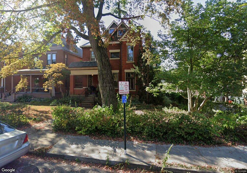
241 W Hubbard Ave Columbus, OH 43215
Victorian Village NeighborhoodEstimated Value: $628,221 - $747,000
2
Beds
3
Baths
2,222
Sq Ft
$309/Sq Ft
Est. Value
About This Home
This home is located at 241 W Hubbard Ave, Columbus, OH 43215 and is currently estimated at $687,055, approximately $309 per square foot. 241 W Hubbard Ave is a home located in Franklin County with nearby schools including Hubbard Elementary School, Dominion Middle School, and Whetstone High School.
Ownership History
Date
Name
Owned For
Owner Type
Purchase Details
Closed on
Aug 3, 1993
Bought by
Stemmer Eric M
Current Estimated Value
Purchase Details
Closed on
Oct 1, 1983
Create a Home Valuation Report for This Property
The Home Valuation Report is an in-depth analysis detailing your home's value as well as a comparison with similar homes in the area
Home Values in the Area
Average Home Value in this Area
Purchase History
| Date | Buyer | Sale Price | Title Company |
|---|---|---|---|
| Stemmer Eric M | $75,000 | -- | |
| -- | $40,000 | -- |
Source: Public Records
Tax History Compared to Growth
Tax History
| Year | Tax Paid | Tax Assessment Tax Assessment Total Assessment is a certain percentage of the fair market value that is determined by local assessors to be the total taxable value of land and additions on the property. | Land | Improvement |
|---|---|---|---|---|
| 2024 | $8,093 | $180,320 | $77,000 | $103,320 |
| 2023 | $7,989 | $180,320 | $77,000 | $103,320 |
| 2022 | $9,198 | $177,350 | $46,100 | $131,250 |
| 2021 | $9,215 | $177,350 | $46,100 | $131,250 |
| 2020 | $9,226 | $177,350 | $46,100 | $131,250 |
| 2019 | $8,931 | $147,220 | $38,400 | $108,820 |
| 2018 | $8,227 | $147,220 | $38,400 | $108,820 |
| 2017 | $8,711 | $147,220 | $38,400 | $108,820 |
| 2016 | $8,496 | $128,250 | $30,420 | $97,830 |
| 2015 | $7,762 | $128,250 | $30,420 | $97,830 |
| 2014 | $7,952 | $128,250 | $30,420 | $97,830 |
| 2013 | $3,615 | $116,585 | $27,650 | $88,935 |
Source: Public Records
Map
Nearby Homes
- 312 Buttles Ave Unit 314
- 884 Neil Ave
- 867-871 Delaware Ave
- 915 Dennison Ave Unit 915
- 938 Hunter Ave
- 313 W 1st Ave
- 85-91 W 1st Ave
- 83 W 1st Ave
- 969 Hunter Ave
- 986 Highland St
- 162 E 2nd Ave
- 998 Ewing Alley Unit 998
- 1001 Dennison Ave
- 1016 Neil Ave
- 1018 Neil Ave
- 994 Harrison Ave
- 37 Buttles Ave Unit D
- 319 W 2nd Ave Unit 319
- 1025 Hunter Ave
- 845 N High St Unit 404
- 235 W Hubbard Ave
- 231 W Hubbard Ave
- 800 Highland St
- 802 Highland St
- 225 W Hubbard Ave
- 804 Neil Ave
- 796 Highland St
- 802 Neil Ave
- 0 238-240-1 2 W Hubbard Ave Unit 4572255-6875531
- 0 238-240-1 2 W Hubbard Ave Unit 4572255-8181434
- 221 W Hubbard Ave
- 800 Neil Ave
- 812 Neil Ave Unit 814
- 812 - 814 Neil Ave
- 242 Buttles Ave
- 798 Neil Ave
- 798 Neil Ave Unit 798.5
- 250 W Hubbard Ave Unit 250
- 217 W Hubbard Ave
- 217 W Hubbard Ave Unit 4