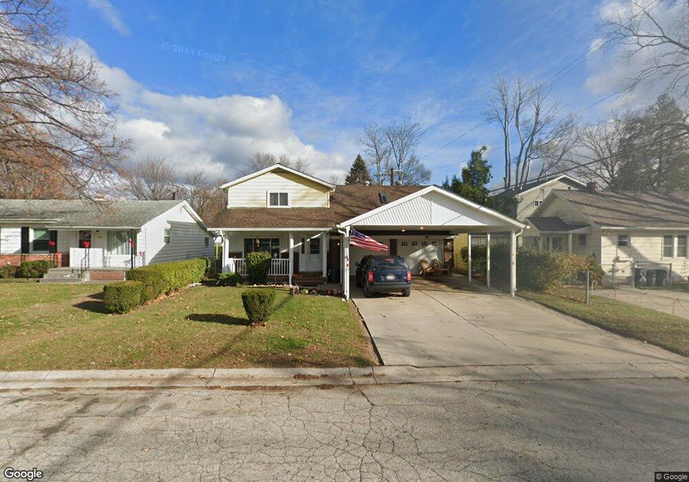
2410 20th Ave Port Huron, MI 48060
Estimated Value: $241,537 - $292,000
3
Beds
2
Baths
1,920
Sq Ft
$137/Sq Ft
Est. Value
About This Home
This home is located at 2410 20th Ave, Port Huron, MI 48060 and is currently estimated at $262,384, approximately $136 per square foot. 2410 20th Ave is a home located in St. Clair County with nearby schools including H.D. Crull Elementary School, Holland Woods Middle School, and Port Huron Northern High School.
Ownership History
Date
Name
Owned For
Owner Type
Purchase Details
Closed on
Aug 15, 2022
Sold by
Gerald L Russel Irrevocable Homestead Pr
Bought by
Scott M Russel Revocable Family Trust
Current Estimated Value
Purchase Details
Closed on
Aug 28, 2019
Sold by
Lambright Melissa
Bought by
Gerald L Trust
Purchase Details
Closed on
Nov 4, 2008
Sold by
Russel Gerald L
Bought by
Lambright Melissa P
Create a Home Valuation Report for This Property
The Home Valuation Report is an in-depth analysis detailing your home's value as well as a comparison with similar homes in the area
Home Values in the Area
Average Home Value in this Area
Purchase History
| Date | Buyer | Sale Price | Title Company |
|---|---|---|---|
| Scott M Russel Revocable Family Trust | -- | Simasko Simasko & Simasko Pc | |
| Gerald L Trust | -- | None Available | |
| Lambright Melissa P | -- | None Available | |
| Russel Gerald L | -- | None Available |
Source: Public Records
Tax History Compared to Growth
Tax History
| Year | Tax Paid | Tax Assessment Tax Assessment Total Assessment is a certain percentage of the fair market value that is determined by local assessors to be the total taxable value of land and additions on the property. | Land | Improvement |
|---|---|---|---|---|
| 2025 | $2,072 | $106,800 | $0 | $0 |
| 2024 | $2,519 | $98,400 | $0 | $0 |
| 2023 | $2,386 | $86,200 | $0 | $0 |
| 2022 | $2,424 | $73,900 | $0 | $0 |
| 2021 | $2,314 | $61,600 | $0 | $0 |
| 2020 | $2,323 | $58,200 | $58,200 | $0 |
| 2019 | $1,631 | $43,700 | $0 | $0 |
| 2018 | $1,595 | $43,700 | $0 | $0 |
| 2017 | $1,424 | $35,700 | $0 | $0 |
| 2016 | $1,216 | $35,700 | $0 | $0 |
| 2015 | $1,194 | $34,600 | $34,600 | $0 |
| 2014 | $1,194 | $34,900 | $34,900 | $0 |
| 2013 | -- | $34,100 | $0 | $0 |
Source: Public Records
Map
Nearby Homes
- 2215 Hancock St
- 2549 Riverwood Dr
- 2812 19th Ave
- 2838 Elmwood St
- 1907 Riverside Dr
- 2806 Woodstock Dr
- 1819 Riverside Dr
- 2857 Riverside Dr
- 0000 Water St
- 0000 Campau Ave
- V/L #4 Water St
- V/L #6 Water St
- V/L #5 Water St
- V/L #8 Water St
- V/L #3 Water St
- 1649 Whipple St
- 1620 McBrady St
- 1531 Robinson St
- 2610 Strawberry Ln
- 1434 Schumaker St