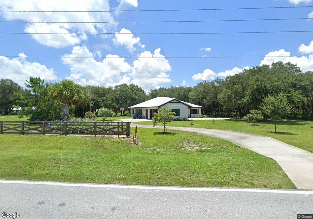
2410 Burns Ave Lake Wales, FL 33898
Estimated Value: $423,000 - $865,000
3
Beds
2
Baths
2,443
Sq Ft
$233/Sq Ft
Est. Value
About This Home
This home is located at 2410 Burns Ave, Lake Wales, FL 33898 and is currently estimated at $569,356, approximately $233 per square foot. 2410 Burns Ave is a home with nearby schools including Spook Hill Elementary School, Bartow Elementary Academy, and Mclaughlin Middle School And Fine Arts Academy.
Ownership History
Date
Name
Owned For
Owner Type
Purchase Details
Closed on
Jun 7, 2018
Sold by
Oakwood Land Company Llp and Oakwood Land Company
Bought by
Hanzlik Andrew and Osemlak Hanzlik M
Current Estimated Value
Home Financials for this Owner
Home Financials are based on the most recent Mortgage that was taken out on this home.
Interest Rate
4.54%
Purchase Details
Closed on
Oct 1, 2016
Bought by
Oakwood Land Company Llp
Purchase Details
Closed on
Dec 28, 1999
Sold by
Clerk Of The Circuit Court
Bought by
Bank Of America N A
Create a Home Valuation Report for This Property
The Home Valuation Report is an in-depth analysis detailing your home's value as well as a comparison with similar homes in the area
Home Values in the Area
Average Home Value in this Area
Purchase History
| Date | Buyer | Sale Price | Title Company |
|---|---|---|---|
| Hanzlik Andrew | $100 | -- | |
| Oakwood Land Company Llp | -- | -- | |
| Bank Of America N A | -- | -- |
Source: Public Records
Mortgage History
| Date | Status | Borrower | Loan Amount |
|---|---|---|---|
| Closed | Bank Of America N A | -- |
Source: Public Records
Tax History Compared to Growth
Tax History
| Year | Tax Paid | Tax Assessment Tax Assessment Total Assessment is a certain percentage of the fair market value that is determined by local assessors to be the total taxable value of land and additions on the property. | Land | Improvement |
|---|---|---|---|---|
| 2025 | $4,556 | $308,353 | -- | -- |
| 2024 | $4,448 | $299,663 | -- | -- |
| 2023 | $4,448 | $290,935 | $0 | $0 |
| 2022 | $4,160 | $282,461 | $0 | $0 |
| 2021 | $4,149 | $271,321 | $0 | $0 |
| 2020 | $4,109 | $267,575 | $0 | $0 |
| 2018 | $788 | $37,993 | $37,993 | $0 |
| 2017 | $88 | $4,257 | $0 | $0 |
| 2016 | $90 | $4,206 | $0 | $0 |
| 2015 | $84 | $3,824 | $0 | $0 |
| 2014 | $77 | $3,476 | $0 | $0 |
Source: Public Records
Map
Nearby Homes
- 2550 Mammoth Grove Rd
- The Belmont Plan at Leighton Landing
- The Providence Plan at Leighton Landing
- The Asheville Plan at Leighton Landing
- The Manchester Plan at Leighton Landing
- The Savannah Plan at Leighton Landing
- The Williamsburg Plan at Leighton Landing
- The Norfolk Plan at Leighton Landing
- The Bristol Plan at Leighton Landing
- The Covington Plan at Leighton Landing
- The Dalton Plan at Leighton Landing
- The Cambridge Plan at Leighton Landing
- The Charlotte Plan at Leighton Landing
- The Hawthorne Plan at Leighton Landing
- The Carolina Plan at Leighton Landing
- The Augusta Plan at Leighton Landing
- The Westminster Plan at Leighton Landing
- The Westfield Plan at Leighton Landing
- The Trenton Plan at Leighton Landing
- The Roanoke II Plan at Leighton Landing