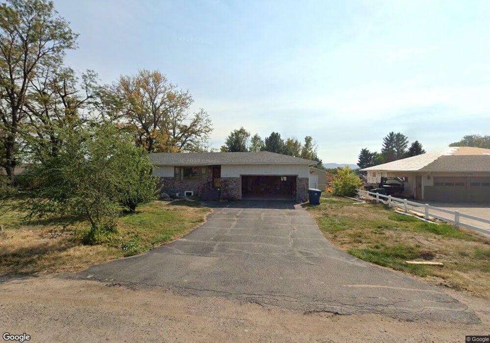
2410 Kingsgate Rd Scottsbluff, NE 69361
Estimated Value: $210,248 - $239,000
3
Beds
1
Bath
1,230
Sq Ft
$184/Sq Ft
Est. Value
About This Home
This home is located at 2410 Kingsgate Rd, Scottsbluff, NE 69361 and is currently estimated at $226,812, approximately $184 per square foot. 2410 Kingsgate Rd is a home located in Scotts Bluff County with nearby schools including Lincoln Heights Elementary School, Bluffs Middle School, and Scottsbluff Senior High School.
Ownership History
Date
Name
Owned For
Owner Type
Purchase Details
Closed on
Dec 29, 2022
Sold by
Vern And Erma Lewellen Family Trust
Bought by
Greenlee Tammi
Current Estimated Value
Purchase Details
Closed on
May 23, 2017
Sold by
Lewellen Erma E
Bought by
Lewellen Erma Eileen and Verne And Erma Lewellen Trust
Purchase Details
Closed on
Jun 21, 2011
Sold by
Riezanstein Wilma
Bought by
Lewellen Verne C and Lewellen Erma E
Create a Home Valuation Report for This Property
The Home Valuation Report is an in-depth analysis detailing your home's value as well as a comparison with similar homes in the area
Home Values in the Area
Average Home Value in this Area
Purchase History
| Date | Buyer | Sale Price | Title Company |
|---|---|---|---|
| Greenlee Tammi | -- | -- | |
| Lewellen Erma Eileen | -- | None Available | |
| Lewellen Verne C | $125,000 | -- |
Source: Public Records
Tax History
| Year | Tax Paid | Tax Assessment Tax Assessment Total Assessment is a certain percentage of the fair market value that is determined by local assessors to be the total taxable value of land and additions on the property. | Land | Improvement |
|---|---|---|---|---|
| 2025 | $2,054 | $192,585 | $28,750 | $163,835 |
| 2024 | $2,121 | $192,585 | $28,750 | $163,835 |
| 2023 | $2,705 | $146,280 | $16,249 | $130,031 |
| 2022 | $2,705 | $146,280 | $16,249 | $130,031 |
| 2021 | $2,633 | $140,088 | $16,249 | $123,839 |
| 2020 | $2,457 | $129,863 | $16,249 | $113,614 |
| 2019 | $2,453 | $129,864 | $16,250 | $113,614 |
| 2018 | $2,470 | $129,864 | $16,250 | $113,614 |
| 2017 | $2,479 | $129,864 | $16,250 | $113,614 |
| 2016 | $2,482 | $129,864 | $16,250 | $113,614 |
| 2015 | $2,462 | $129,864 | $16,250 | $113,614 |
| 2014 | $2,211 | $125,494 | $16,250 | $109,244 |
| 2012 | -- | $125,494 | $16,250 | $109,244 |
Source: Public Records
Map
Nearby Homes
- 2307 W 42nd St Unit Lot 3
- 2307 W 42nd St Unit Lot 45
- 4313 Cottonwood Ave
- 2817 W 42nd St
- 1012 W 36th St
- 90208 County Road 19
- 597 Sagebrush Dr
- 501 W 38th St
- TBD W 36th St
- 0 W 36th St Unit 20254154
- 415 W 36th St
- 1010 W 29th St
- 10 Stoney Creek Dr
- 1011 W 27th St
- 2918 Avenue H
- 2809 Avenue I
- 410 Sandra Ct
- 501 W 32nd St
- 3415 Ross Ave
- Lot 1 31st St
- 2414 Kingsgate Rd
- 2402 Kingsgate Rd
- 2502 Kingsgate Rd
- 2401 Kingsgate Rd
- 2318 Kingsgate Rd
- 2417 Kingsgate Rd
- 2409 Highland Dr
- 2401 Highland Dr
- 2417 Highland Dr
- 2501 Kingsgate Rd
- 2501 Highland Dr
- 2310 Kingsgate Rd
- 2317 Highland Dr
- 2314 Hilltop Dr
- 2509 Highland Dr
- 2311 Kingsgate Rd
- 2309 Highland Dr
- 2514 Kingsgate Rd
- 2302 Kingsgate Rd
- 2410 Highland Dr
Your Personal Tour Guide
Ask me questions while you tour the home.