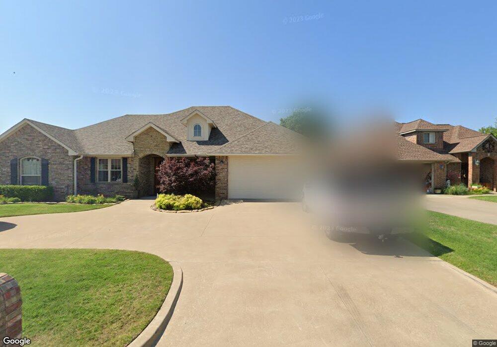
2410 Mallard Duncan, OK 73533
Estimated Value: $264,000 - $346,000
4
Beds
3
Baths
2,115
Sq Ft
$147/Sq Ft
Est. Value
About This Home
This home is located at 2410 Mallard, Duncan, OK 73533 and is currently estimated at $310,613, approximately $146 per square foot. 2410 Mallard is a home with nearby schools including Horace Mann Elementary School, Duncan Middle School, and Duncan High School.
Ownership History
Date
Name
Owned For
Owner Type
Purchase Details
Closed on
May 15, 2007
Sold by
Duwe David L and Duwe Donna J
Bought by
Morrow Raymond L and Morrow Jamie S
Current Estimated Value
Home Financials for this Owner
Home Financials are based on the most recent Mortgage that was taken out on this home.
Original Mortgage
$172,500
Interest Rate
6.16%
Mortgage Type
Construction
Purchase Details
Closed on
Oct 4, 2004
Sold by
Wjw Development
Create a Home Valuation Report for This Property
The Home Valuation Report is an in-depth analysis detailing your home's value as well as a comparison with similar homes in the area
Purchase History
| Date | Buyer | Sale Price | Title Company |
|---|---|---|---|
| Morrow Raymond L | $18,000 | None Available | |
| -- | $280,000 | -- |
Source: Public Records
Mortgage History
| Date | Status | Borrower | Loan Amount |
|---|---|---|---|
| Closed | Morrow Raymond L | $172,500 |
Source: Public Records
Tax History
| Year | Tax Paid | Tax Assessment Tax Assessment Total Assessment is a certain percentage of the fair market value that is determined by local assessors to be the total taxable value of land and additions on the property. | Land | Improvement |
|---|---|---|---|---|
| 2025 | $2,633 | $32,213 | $1,746 | $30,467 |
| 2024 | $2,501 | $30,364 | $1,746 | $28,618 |
| 2023 | $2,501 | $30,364 | $1,746 | $28,618 |
| 2022 | $2,348 | $29,480 | $1,746 | $27,734 |
| 2021 | $2,281 | $27,788 | $1,746 | $26,042 |
| 2020 | $2,394 | $28,727 | $1,746 | $26,981 |
| 2019 | $2,384 | $28,559 | $1,746 | $26,813 |
| 2018 | $2,380 | $28,559 | $1,746 | $26,813 |
| 2017 | $2,228 | $26,920 | $1,746 | $25,174 |
| 2016 | $2,177 | $26,617 | $1,746 | $24,871 |
| 2015 | $2,062 | $26,617 | $1,746 | $24,871 |
| 2014 | $2,062 | $24,057 | $1,746 | $22,311 |
Source: Public Records
Map
Nearby Homes
- 2407 W Mallard Dr
- 2201 Mallard
- 2310 Rockwell Dr
- 2360 Rockwell Dr
- 2333 Rockwell Dr
- 2321 Rockwell Dr
- 2129 W Mallard Dr
- 2387 Rockwell Dr
- NO ADDRESS W Elk Ave
- 2375 Rockwell Dr
- 2705 Meadowview Dr
- 2363 Rockwell Dr
- 2345 Rockwell Dr
- 2346 Rockwell Dr
- Monroe Plan at Wilkinson
- Jefferson Plan at Wilkinson
- Roosevelt Plan at Wilkinson
- 2202 Flamingo Ln
- 2318 Rockwell Dr
- 2403 Meadow View Dr
Your Personal Tour Guide
Ask me questions while you tour the home.