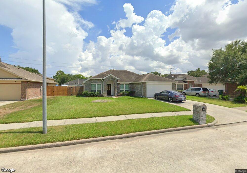
2411 Havencrest Dr Houston, TX 77038
North Houston NeighborhoodEstimated Value: $219,000 - $279,000
3
Beds
2
Baths
1,748
Sq Ft
$139/Sq Ft
Est. Value
About This Home
This home is located at 2411 Havencrest Dr, Houston, TX 77038 and is currently estimated at $242,833, approximately $138 per square foot. 2411 Havencrest Dr is a home located in Harris County with nearby schools including Gloria B. Sammons Elementary School, Stovall School, and Dr. Viola K. Garcia Middle School.
Ownership History
Date
Name
Owned For
Owner Type
Purchase Details
Closed on
Jun 28, 1999
Sold by
Royce Homes Lp
Bought by
Bates John
Current Estimated Value
Home Financials for this Owner
Home Financials are based on the most recent Mortgage that was taken out on this home.
Original Mortgage
$72,450
Outstanding Balance
$19,733
Interest Rate
7.21%
Mortgage Type
Stand Alone First
Estimated Equity
$223,100
Create a Home Valuation Report for This Property
The Home Valuation Report is an in-depth analysis detailing your home's value as well as a comparison with similar homes in the area
Home Values in the Area
Average Home Value in this Area
Purchase History
| Date | Buyer | Sale Price | Title Company |
|---|---|---|---|
| Bates John | -- | Stewart Title |
Source: Public Records
Mortgage History
| Date | Status | Borrower | Loan Amount |
|---|---|---|---|
| Open | Bates John | $72,450 |
Source: Public Records
Tax History Compared to Growth
Tax History
| Year | Tax Paid | Tax Assessment Tax Assessment Total Assessment is a certain percentage of the fair market value that is determined by local assessors to be the total taxable value of land and additions on the property. | Land | Improvement |
|---|---|---|---|---|
| 2025 | $4,946 | $234,488 | $41,562 | $192,926 |
| 2024 | $4,946 | $229,628 | $41,562 | $188,066 |
| 2023 | $4,946 | $229,628 | $41,562 | $188,066 |
| 2022 | $5,516 | $223,982 | $25,976 | $198,006 |
| 2021 | $5,180 | $168,649 | $25,976 | $142,673 |
| 2020 | $4,978 | $153,121 | $18,833 | $134,288 |
| 2019 | $4,729 | $150,718 | $18,833 | $131,885 |
| 2018 | $1,447 | $144,747 | $18,833 | $125,914 |
| 2017 | $3,848 | $133,561 | $12,988 | $120,573 |
| 2016 | $3,498 | $120,142 | $12,988 | $107,154 |
| 2015 | $2,681 | $120,142 | $12,988 | $107,154 |
| 2014 | $2,681 | $85,885 | $12,988 | $72,897 |
Source: Public Records
Map
Nearby Homes
- 12718 Sai Baba Dr
- 2203 Chalet Rd
- 2115 Havencrest Dr
- Whitetail Plan at Forestwood
- Kitson Plan at Forestwood
- Pinehollow Plan at Forestwood
- 12530 Wild Strawberry Rd
- Idlewood Plan at Forestwood
- Oakridge Plan at Forestwood
- 12518 Pelican Bay Dr
- 0 W Mt Houston Rd Unit 90464120
- 2614 Lemonwood Ln
- 00 Fallbrook Dr
- 1506 Wilshire Park Dr
- 2610 Cabin Cove Ln
- 1327 Fallbrook Dr
- 2702 Urban Glen Ct
- 2811 Oakland Brook St
- 2838 Packard Elm St
- 2831 Oakland Brook St
- 2407 Havencrest Dr
- 2415 Havencrest Dr
- 2410 Cherryville Dr
- 2414 Cherryville Dr
- 2403 Havencrest Dr
- 2419 Havencrest Dr
- 2406 Cherryville Dr
- 2418 Cherryville Dr
- 2414 Havencrest Dr
- 2327 Havencrest Dr
- 2402 Cherryville Dr
- 2330 Havencrest Dr
- 2323 Havencrest Dr
- 2318 Cherryville Dr
- 2411 Cherryville Dr
- 2407 Cherryville Dr
- 2326 Havencrest Dr
- 2415 Chalet Rd
- 12811 Edgewood Park Dr
- 2419 Chalet Rd