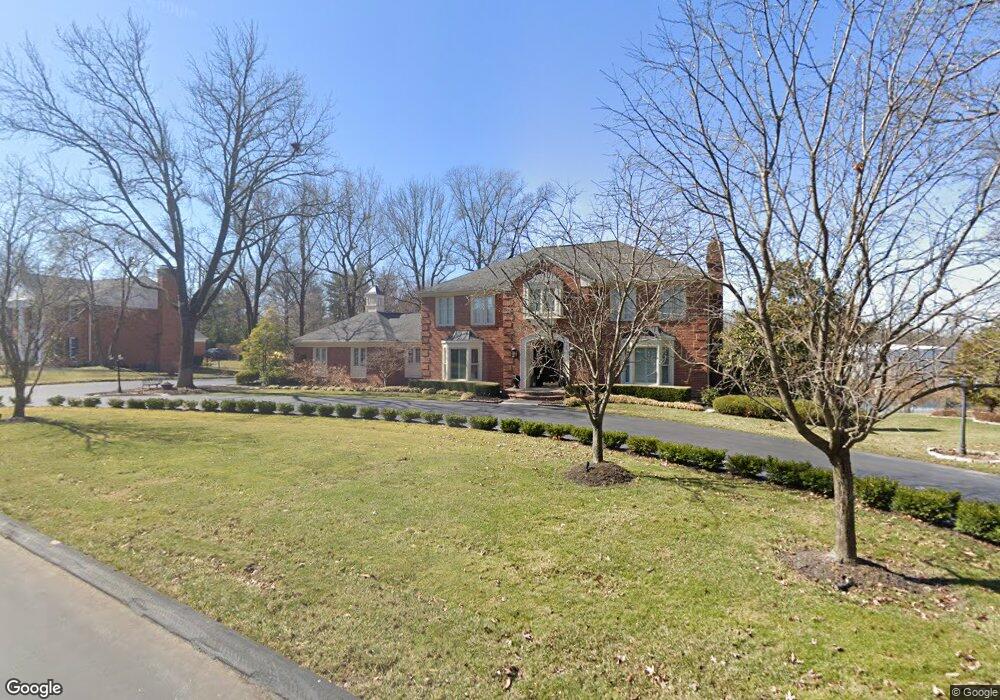
2417 White Stable Rd Saint Louis, MO 63131
Estimated Value: $1,094,777 - $1,485,000
4
Beds
5
Baths
3,550
Sq Ft
$375/Sq Ft
Est. Value
About This Home
This home is located at 2417 White Stable Rd, Saint Louis, MO 63131 and is currently estimated at $1,329,944, approximately $374 per square foot. 2417 White Stable Rd is a home located in St. Louis County with nearby schools including Mason Ridge Elementary School, Parkway West Middle School, and Parkway West High School.
Ownership History
Date
Name
Owned For
Owner Type
Purchase Details
Closed on
Aug 20, 2003
Sold by
Abinoja Conrado B
Bought by
Pearman Matt and Pearman Monica
Current Estimated Value
Home Financials for this Owner
Home Financials are based on the most recent Mortgage that was taken out on this home.
Original Mortgage
$512,000
Outstanding Balance
$235,277
Interest Rate
6.22%
Mortgage Type
Purchase Money Mortgage
Estimated Equity
$1,094,667
Create a Home Valuation Report for This Property
The Home Valuation Report is an in-depth analysis detailing your home's value as well as a comparison with similar homes in the area
Home Values in the Area
Average Home Value in this Area
Purchase History
| Date | Buyer | Sale Price | Title Company |
|---|---|---|---|
| Pearman Matt | $640,000 | -- |
Source: Public Records
Mortgage History
| Date | Status | Borrower | Loan Amount |
|---|---|---|---|
| Open | Pearman Matt | $512,000 |
Source: Public Records
Tax History Compared to Growth
Tax History
| Year | Tax Paid | Tax Assessment Tax Assessment Total Assessment is a certain percentage of the fair market value that is determined by local assessors to be the total taxable value of land and additions on the property. | Land | Improvement |
|---|---|---|---|---|
| 2025 | $8,809 | $187,380 | $85,520 | $101,860 |
| 2024 | $8,809 | $151,430 | $76,020 | $75,410 |
| 2023 | $8,337 | $151,430 | $76,020 | $75,410 |
| 2022 | $9,293 | $153,390 | $85,520 | $67,870 |
| 2021 | $9,216 | $153,390 | $85,520 | $67,870 |
| 2020 | $8,811 | $140,220 | $85,500 | $54,720 |
| 2019 | $8,687 | $140,220 | $85,500 | $54,720 |
| 2018 | $8,716 | $130,070 | $76,000 | $54,070 |
| 2017 | $8,598 | $130,070 | $76,000 | $54,070 |
| 2016 | $8,391 | $120,670 | $66,500 | $54,170 |
| 2015 | $8,845 | $120,670 | $66,500 | $54,170 |
| 2014 | $9,827 | $145,640 | $50,390 | $95,250 |
Source: Public Records
Map
Nearby Homes
- 2409 N Ballas Rd
- 0 Unknown Unit 22071090
- 12549 Bickford Dr
- 9 Kirken Knoll Dr
- 5 W Point Ln
- 11 Roclare Ln
- 2056 N Ballas Rd
- 2062 N Ballas Rd
- TBB
- TBB Ballas Ridge Westchester IV
- TBB Ballas Ridge Hawthorne II
- TBB Ballas Ridge Roclare II
- TBB
- The Hawthorne Plan at Ballas Ridge
- The Roclare II Plan at Ballas Ridge
- The Westchester IV Plan at Ballas Ridge
- The Nottingham II Plan at Ballas Ridge
- The Hawthorne II Plan at Ballas Ridge
- Pearson Plan at Deer Hollow - Masterpiece Collection
- Clay Plan at Deer Hollow - Masterpiece Collection
- 2405 White Stable Rd
- 12680 Spruce Pond Dr
- 12655 Clayton Rd
- 12692 Spruce Pond Dr
- 2416 White Stable Rd
- 2404 White Stable Rd
- 12667 Clayton Rd
- 2430 White Stable Rd
- 12706 Spruce Pond Dr
- 12679 Spruce Pond Dr
- 2442 White Stable Rd
- 12556 Clayton Rd
- 2440 Copper Beech Dr
- 12715 Clayton Rd
- 12718 Spruce Pond Dr
- 2332 Mueller Ln
- 2454 White Stable Rd
- 23 Country Life Acres
- 2445 Copper Beech Dr