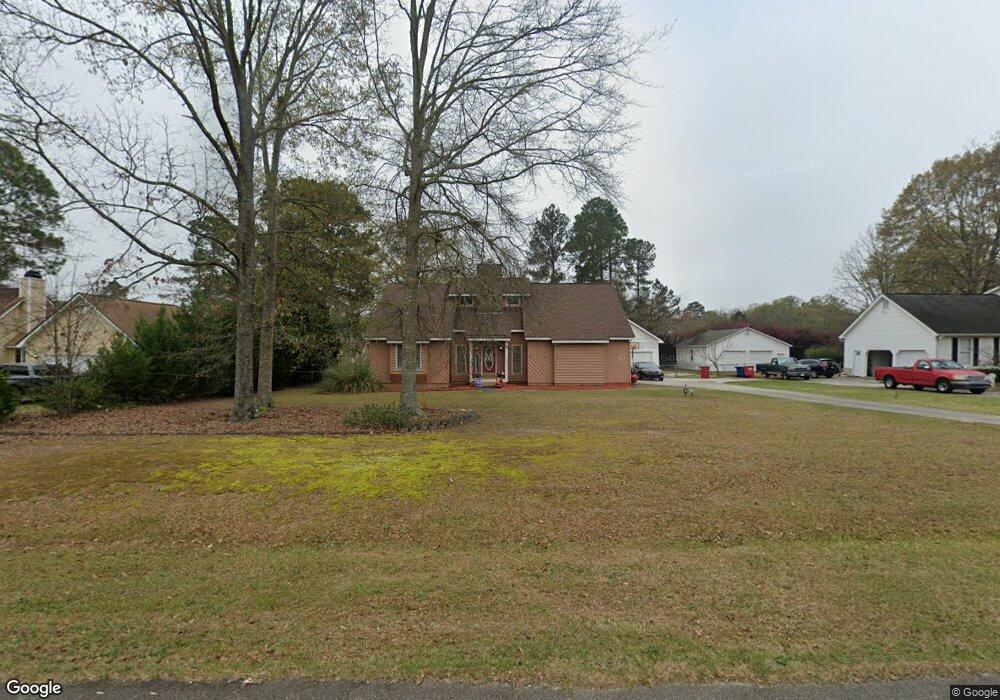
242 Forest Pine Dr Macon, GA 31216
Estimated Value: $264,000 - $283,000
3
Beds
2
Baths
2,063
Sq Ft
$132/Sq Ft
Est. Value
About This Home
This home is located at 242 Forest Pine Dr, Macon, GA 31216 and is currently estimated at $272,947, approximately $132 per square foot. 242 Forest Pine Dr is a home located in Bibb County with nearby schools including Porter Elementary School, Rutland Middle School, and Rutland High School.
Ownership History
Date
Name
Owned For
Owner Type
Purchase Details
Closed on
Jun 17, 2005
Sold by
Worden Fred and Worden Kimberly L
Bought by
Moore Terrance A
Current Estimated Value
Home Financials for this Owner
Home Financials are based on the most recent Mortgage that was taken out on this home.
Original Mortgage
$164,221
Outstanding Balance
$84,633
Interest Rate
5.66%
Mortgage Type
FHA
Estimated Equity
$188,314
Purchase Details
Closed on
Sep 5, 2003
Purchase Details
Closed on
Apr 12, 2002
Create a Home Valuation Report for This Property
The Home Valuation Report is an in-depth analysis detailing your home's value as well as a comparison with similar homes in the area
Purchase History
| Date | Buyer | Sale Price | Title Company |
|---|---|---|---|
| Moore Terrance A | $166,800 | None Available | |
| -- | -- | -- | |
| -- | $112,000 | -- |
Source: Public Records
Mortgage History
| Date | Status | Borrower | Loan Amount |
|---|---|---|---|
| Open | Moore Terrance A | $164,221 |
Source: Public Records
Tax History
| Year | Tax Paid | Tax Assessment Tax Assessment Total Assessment is a certain percentage of the fair market value that is determined by local assessors to be the total taxable value of land and additions on the property. | Land | Improvement |
|---|---|---|---|---|
| 2025 | $2,416 | $105,334 | $16,000 | $89,334 |
| 2024 | $2,458 | $103,780 | $16,000 | $87,780 |
| 2023 | $2,471 | $97,291 | $16,000 | $81,291 |
| 2022 | $2,936 | $84,817 | $8,840 | $75,977 |
| 2021 | $2,782 | $73,207 | $8,840 | $64,367 |
| 2020 | $2,451 | $63,135 | $7,514 | $55,621 |
| 2019 | $2,471 | $63,135 | $7,514 | $55,621 |
| 2018 | $3,753 | $59,601 | $7,514 | $52,087 |
| 2017 | $2,207 | $58,901 | $7,514 | $51,387 |
| 2016 | $1,937 | $55,974 | $7,072 | $48,902 |
| 2015 | $2,741 | $55,974 | $7,072 | $48,902 |
| 2014 | $2,886 | $58,851 | $7,072 | $51,779 |
Source: Public Records
Map
Nearby Homes
- 180 Ridge Cir
- 141 Bransford Dr
- 221 Pendleton Ct
- 3906 Hartley Bridge Rd
- 3812 Western Way
- 104 Tyler Ct
- 106 Hudson Way
- 4005 Springhead Way Unit LOT 100
- 4003 Springhead Way Unit LOT 101
- 4009 Springhead Way Unit LOT 98
- 4001 Springhead Way Unit LOT 102
- 3636 Bonanza Dr
- 5514 Bankston Lake Rd
- 5524 Bankston Lake Rd
- 5731 School Rd
- 123 Hudson Way
- 5608 Swymer Dr
- 1066 Alma Dr
- 219 Trenton Terrace
- 171 Mcclain Cir
- 236 Forest Pine Dr
- 248 Forest Pine Dr
- 151 Ridge Cir
- 230 Forest Pine Dr
- 137 Ridge Cir
- 241 Forest Pine Dr
- 235 Forest Pine Dr
- 247 Forest Pine Dr
- 131 Ridge Cir
- 166 Ridge Cir
- 229 Forest Pine Dr
- 224 Forest Pine Dr
- 125 Ridge Cir
- 253 Forest Pine Dr
- 160 Ridge Cir Unit 28
- 223 Forest Pine Dr
- 142 Ridge Cir
- 184 Ridge Cir
- 262 Forest Pine Dr
- 334 Old Oak Rd
Your Personal Tour Guide
Ask me questions while you tour the home.