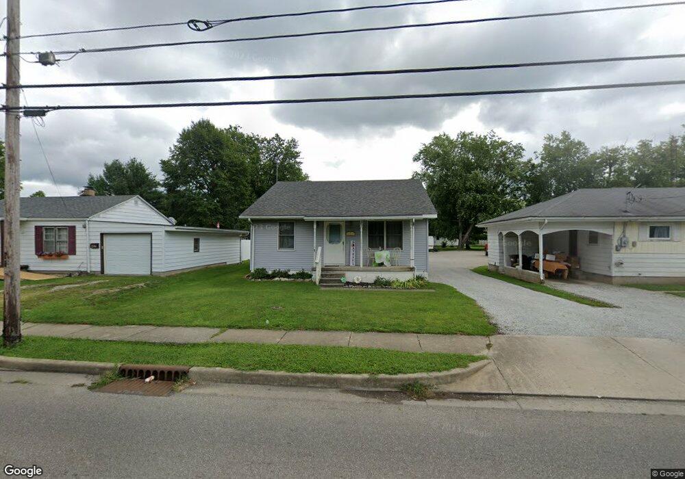
242 Norris Ave North Vernon, IN 47265
Estimated Value: $140,000 - $161,000
2
Beds
1
Bath
1,064
Sq Ft
$143/Sq Ft
Est. Value
About This Home
This home is located at 242 Norris Ave, North Vernon, IN 47265 and is currently estimated at $152,638, approximately $143 per square foot. 242 Norris Ave is a home located in Jennings County with nearby schools including North Vernon Elementary School, Jennings County Middle School, and Jennings County High School.
Ownership History
Date
Name
Owned For
Owner Type
Purchase Details
Closed on
May 5, 2006
Sold by
Perkins Drucilla
Bought by
Perkins Billy Dee and Perkins Drucilla
Current Estimated Value
Home Financials for this Owner
Home Financials are based on the most recent Mortgage that was taken out on this home.
Original Mortgage
$60,000
Outstanding Balance
$34,730
Interest Rate
6.39%
Mortgage Type
New Conventional
Estimated Equity
$117,908
Purchase Details
Closed on
May 25, 2000
Sold by
Rellie Turner
Bought by
Perkins Drucilla
Create a Home Valuation Report for This Property
The Home Valuation Report is an in-depth analysis detailing your home's value as well as a comparison with similar homes in the area
Home Values in the Area
Average Home Value in this Area
Purchase History
| Date | Buyer | Sale Price | Title Company |
|---|---|---|---|
| Perkins Billy Dee | -- | None Available | |
| Perkins Drucilla | -- | -- |
Source: Public Records
Mortgage History
| Date | Status | Borrower | Loan Amount |
|---|---|---|---|
| Open | Perkins Billy Dee | $60,000 |
Source: Public Records
Tax History Compared to Growth
Tax History
| Year | Tax Paid | Tax Assessment Tax Assessment Total Assessment is a certain percentage of the fair market value that is determined by local assessors to be the total taxable value of land and additions on the property. | Land | Improvement |
|---|---|---|---|---|
| 2024 | $1,033 | $103,300 | $11,400 | $91,900 |
| 2023 | $774 | $89,800 | $11,400 | $78,400 |
| 2022 | $617 | $80,400 | $11,400 | $69,000 |
| 2021 | $530 | $72,900 | $11,400 | $61,500 |
| 2020 | $468 | $68,800 | $11,300 | $57,500 |
| 2019 | $1,290 | $64,500 | $11,300 | $53,200 |
| 2018 | $1,210 | $60,500 | $11,300 | $49,200 |
| 2017 | $1,198 | $59,900 | $11,300 | $48,600 |
| 2016 | $1,222 | $61,100 | $11,300 | $49,800 |
| 2014 | $388 | $63,800 | $11,300 | $52,500 |
Source: Public Records
Map
Nearby Homes
- 237 Norris Ave
- 210 Norris Ave
- 82 Norris Ave
- 112 Sunnyside Dr
- 100 Durbin St
- 174 E Norris Heights
- 208 South St
- 215 S Gum St
- 243 Lincoln St
- 26 Oakwood Ave
- 150 W Walnut St
- 25 W Chestnut St
- 0 W Walnut St Unit MBR22050857
- 3 S State St
- 10 Hicks St
- 3 N State St
- 0 W Cr 100 N Unit MBR22010725
- 604 N Elm St
- The Wyatt (Slab) Plan at Heritage Estates
- The Harrison (Walkout Basement) Plan at Heritage Estates
- 246 Norris Ave
- 250 Norris Ave
- 224 Norris Ave
- 252 Norris Ave
- 221 Sunnyside Dr
- 241 Norris Ave
- 222 Norris Ave
- 254 Norris Ave
- 225 Sunnyside Dr
- 213 Sunnyside Dr
- 233 Norris Ave
- 211 Sunnyside Dr
- 223 Norris Ave
- 301 Norris Ave
- 219 Norris Ave
- 219 Norris Ave
- 301 Sunnyside Dr
- 0 Norris Ave Unit 202035853
- 214 Norris Ave