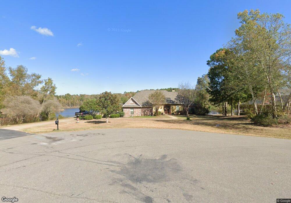
242 Saint Andrews Rd Calhoun, LA 71225
Estimated Value: $603,269 - $629,000
6
Beds
5
Baths
3,770
Sq Ft
$163/Sq Ft
Est. Value
About This Home
This home is located at 242 Saint Andrews Rd, Calhoun, LA 71225 and is currently estimated at $616,317, approximately $163 per square foot. 242 Saint Andrews Rd is a home located in Ouachita Parish with nearby schools including Calhoun Elementary School, Central Elementary School, and Calhoun Middle School.
Ownership History
Date
Name
Owned For
Owner Type
Purchase Details
Closed on
Mar 18, 2020
Sold by
Foster Pedigo
Bought by
Ratliff Matthew D and Miller Tracy N
Current Estimated Value
Home Financials for this Owner
Home Financials are based on the most recent Mortgage that was taken out on this home.
Original Mortgage
$358,500
Outstanding Balance
$316,897
Interest Rate
3.4%
Mortgage Type
New Conventional
Estimated Equity
$299,420
Create a Home Valuation Report for This Property
The Home Valuation Report is an in-depth analysis detailing your home's value as well as a comparison with similar homes in the area
Home Values in the Area
Average Home Value in this Area
Purchase History
| Date | Buyer | Sale Price | Title Company |
|---|---|---|---|
| Ratliff Matthew D | $478,000 | None Available |
Source: Public Records
Mortgage History
| Date | Status | Borrower | Loan Amount |
|---|---|---|---|
| Open | Ratliff Matthew D | $358,500 |
Source: Public Records
Tax History Compared to Growth
Tax History
| Year | Tax Paid | Tax Assessment Tax Assessment Total Assessment is a certain percentage of the fair market value that is determined by local assessors to be the total taxable value of land and additions on the property. | Land | Improvement |
|---|---|---|---|---|
| 2024 | $3,252 | $47,484 | $6,525 | $40,959 |
| 2023 | $3,252 | $44,406 | $6,525 | $37,881 |
| 2022 | $3,939 | $44,406 | $6,525 | $37,881 |
| 2021 | $3,989 | $44,406 | $6,525 | $37,881 |
| 2020 | $3,989 | $44,406 | $6,525 | $37,881 |
| 2019 | $3,487 | $38,933 | $5,400 | $33,533 |
| 2018 | $2,815 | $38,933 | $5,400 | $33,533 |
| 2017 | $3,487 | $38,933 | $5,400 | $33,533 |
| 2016 | $3,485 | $36,600 | $6,800 | $29,800 |
| 2015 | $2,600 | $36,600 | $6,800 | $29,800 |
| 2014 | $2,600 | $36,600 | $6,800 | $29,800 |
| 2013 | $2,590 | $36,600 | $6,800 | $29,800 |
Source: Public Records
Map
Nearby Homes
- 257 Sugarloaf Dr
- 0 Laguna Villas Dr
- 138 Mangum Ln
- 3235 Highway 15
- 0 (A) Carter Rd
- 0 (B) Carter Rd
- 000 C Carter Rd
- 3375 Highway 15
- 201 Glen Acres Rd
- 111 Yellow Pine Dr
- 000 J T Griggs Rd Unit 454 J T Griggs Road
- 131 Yellow Pine Dr
- 00 J T Griggs Rd Unit 454 J T Griggs Road
- 454 J T Griggs Rd
- 0 J T Griggs Rd Unit 454 J T Griggs Road
- 301 Pine Hills Dr
- 159 Chapel Ln
- 1014 Highway 80 E
- 430 Pine Hills Dr
- 3 Wilson - Turner Ln
- 242 Saint Andrews Dr
- 240 Saint Andrews Rd
- 238 Saint Andrews Dr
- 235 Saint Andrews Rd
- 233 Saint Andrews Rd
- 234 Saint Andrews Dr
- 233 Saint Andrews Rd
- 232 Saint Andrews Rd
- 232 Saint Andrews Dr
- 231 Saint Andrews Rd
- 230 Saint Andrews Rd
- 257 Sugarloaf Ln
- 230 Saint Andrews Rd
- 228 Saint Andrews Dr
- 1570 Brownlee Rd
- 226 Saint Andrews Rd
- 226 Saint Andrews Dr
- 1594 Brownlee Rd
- 239 Sugarloaf Rd
- 1638 Brownlee Rd