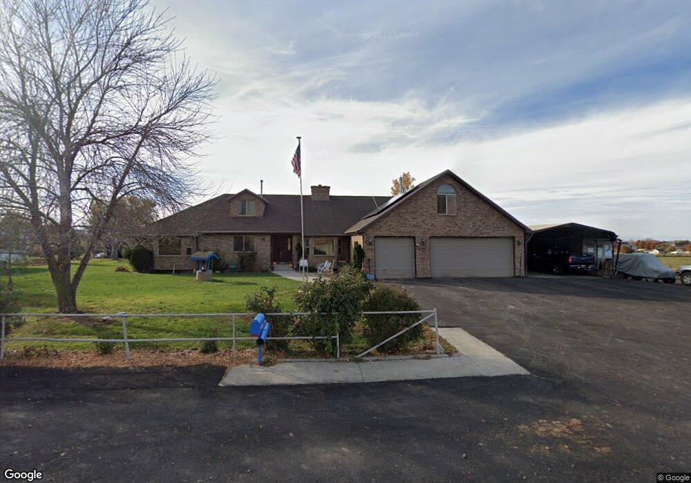
2420 S 800 W Mapleton, UT 84664
Estimated Value: $1,198,000 - $1,574,627
3
Beds
3
Baths
3,202
Sq Ft
$433/Sq Ft
Est. Value
About This Home
This home is located at 2420 S 800 W, Mapleton, UT 84664 and is currently estimated at $1,386,314, approximately $432 per square foot. 2420 S 800 W is a home located in Utah County with nearby schools including Maple Ridge Elementary, Mapleton Junior High School, and Maple Mountain High School.
Ownership History
Date
Name
Owned For
Owner Type
Purchase Details
Closed on
Jun 18, 2025
Sold by
C Wynn And Marian B Everett Legacy Trust and Everett Charles Wynn
Bought by
C Wynn And Marian B Everett Legacy Trust and Everett
Current Estimated Value
Purchase Details
Closed on
Jun 13, 2024
Sold by
Everett Cyruss Wynn
Bought by
C Wynn And Marian B Everett Legacy Trust and Everett
Purchase Details
Closed on
Sep 10, 2007
Sold by
Everett Wynn and Everett Marian B
Bought by
Everett C Wynn and Everett Marian B
Create a Home Valuation Report for This Property
The Home Valuation Report is an in-depth analysis detailing your home's value as well as a comparison with similar homes in the area
Home Values in the Area
Average Home Value in this Area
Purchase History
| Date | Buyer | Sale Price | Title Company |
|---|---|---|---|
| C Wynn And Marian B Everett Legacy Trust | -- | None Listed On Document | |
| Everett Cyruss Wynn | -- | None Listed On Document | |
| C Wynn And Marian B Everett Legacy Trust | -- | None Listed On Document | |
| Everett C Wynn | -- | None Available |
Source: Public Records
Tax History
| Year | Tax Paid | Tax Assessment Tax Assessment Total Assessment is a certain percentage of the fair market value that is determined by local assessors to be the total taxable value of land and additions on the property. | Land | Improvement |
|---|---|---|---|---|
| 2025 | $3,760 | $417,591 | -- | -- |
| 2024 | $3,760 | $368,344 | $0 | $0 |
| 2023 | $3,940 | $388,401 | $0 | $0 |
| 2022 | $3,656 | $1,451,500 | $999,200 | $452,300 |
| 2021 | $3,151 | $1,091,600 | $743,700 | $347,900 |
| 2020 | $2,774 | $997,600 | $649,700 | $347,900 |
| 2019 | $2,410 | $788,300 | $485,800 | $302,500 |
| 2018 | $2,403 | $680,500 | $396,600 | $283,900 |
| 2017 | $2,285 | $170,581 | $0 | $0 |
| 2016 | $2,051 | $152,219 | $0 | $0 |
| 2015 | $2,064 | $152,205 | $0 | $0 |
Source: Public Records
Map
Nearby Homes
- 1060 W 2620 S
- 525 N 1550 W Unit COLUMB
- 525 N 1550 W Unit WINDSO
- 525 N 1550 W Unit HILDAL
- 3713 S White Ash Dr
- 525 N 1550 W Unit BALLAR
- 525 N 1550 W Unit CALDWE
- 525 N 1550 W Unit DREXEL
- 525 N 1550 W Unit MORGAN
- 525 N 1550 W Unit WAKEFI
- 525 N 1550 W Unit ARDEN
- 3958 S Sage Wood Ave Unit CHAMBE
- 1325 W Park Meadows Dr
- 7500 U S Highway 89
- 1353 Mapleton Heights Ct
- 1501 W Elk View Cir
- 872 W Union Bench Dr
- 831 W Rock Ridge Dr
- 4695 S 690 W Unit U204
- 2057 E Maple Hills Ln
- 768 W Triple Crown Dr
- 2333 S 800 W
- 779 W Triple Crown Dr
- 2525 S 800 W
- 2301 S 800 W
- 757 W Triple Crown Dr Unit 38
- 2561 S 800 W
- 757 W Triple Crown Dr Unit 38
- 650 W 2400 S
- 742 W Triple Crown Dr Unit 33
- 1061 S 1550 W Unit 13
- 1022 S 1550 W Unit 4
- 1022 S 1550 W
- 1017 S 1550 W Unit 12
- 1076 S 1550 W Unit 3
- 2503 S 800 W Unit 46
- 2503 S 800 W Unit 45
- 2503 S 800 W
- 2275 S 800 W
- 850 W 2620 S
Your Personal Tour Guide
Ask me questions while you tour the home.