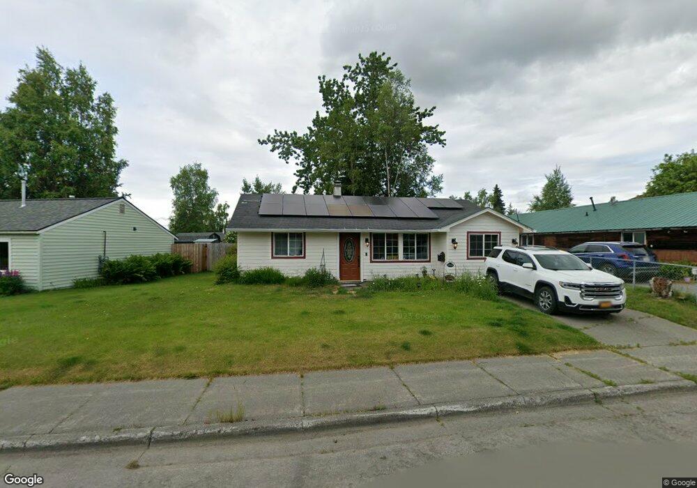
2421 Oak Dr Anchorage, AK 99508
Airport Heights NeighborhoodEstimated Value: $184,000 - $342,000
3
Beds
1
Bath
1,010
Sq Ft
$264/Sq Ft
Est. Value
About This Home
This home is located at 2421 Oak Dr, Anchorage, AK 99508 and is currently estimated at $266,787, approximately $264 per square foot. 2421 Oak Dr is a home located in Anchorage Municipality with nearby schools including Airport Heights Elementary School, Wendler Middle School, and Bettye Davis East Anchorage High School.
Ownership History
Date
Name
Owned For
Owner Type
Purchase Details
Closed on
May 25, 2012
Sold by
Shamp Victoria L and Martin Victoria L
Bought by
Shamp Victoria L and Shamp Dana A
Current Estimated Value
Home Financials for this Owner
Home Financials are based on the most recent Mortgage that was taken out on this home.
Original Mortgage
$150,000
Outstanding Balance
$103,362
Interest Rate
3.86%
Mortgage Type
New Conventional
Estimated Equity
$163,425
Purchase Details
Closed on
Jun 8, 1998
Sold by
Haggerty Patricia A
Bought by
Martin Victoria L
Home Financials for this Owner
Home Financials are based on the most recent Mortgage that was taken out on this home.
Original Mortgage
$0
Interest Rate
7.1%
Mortgage Type
FHA
Purchase Details
Closed on
Oct 7, 1993
Sold by
Goss Edward L
Bought by
Haggerty Patricia A
Home Financials for this Owner
Home Financials are based on the most recent Mortgage that was taken out on this home.
Original Mortgage
$79,773
Interest Rate
6.98%
Mortgage Type
FHA
Create a Home Valuation Report for This Property
The Home Valuation Report is an in-depth analysis detailing your home's value as well as a comparison with similar homes in the area
Home Values in the Area
Average Home Value in this Area
Purchase History
| Date | Buyer | Sale Price | Title Company |
|---|---|---|---|
| Shamp Victoria L | -- | First American Title Ins Co | |
| Martin Victoria L | -- | -- | |
| Martin Victoria L | -- | -- | |
| Haggerty Patricia A | -- | -- |
Source: Public Records
Mortgage History
| Date | Status | Borrower | Loan Amount |
|---|---|---|---|
| Open | Shamp Victoria L | $150,000 | |
| Closed | Martin Victoria L | $0 | |
| Previous Owner | Haggerty Patricia A | $79,773 | |
| Closed | Martin Victoria L | $0 |
Source: Public Records
Tax History
| Year | Tax Paid | Tax Assessment Tax Assessment Total Assessment is a certain percentage of the fair market value that is determined by local assessors to be the total taxable value of land and additions on the property. | Land | Improvement |
|---|---|---|---|---|
| 2025 | $3,027 | $277,000 | $87,400 | $189,600 |
| 2024 | $3,027 | $262,500 | $87,400 | $175,100 |
| 2023 | $4,057 | $238,200 | $87,400 | $150,800 |
| 2022 | $3,233 | $240,000 | $87,400 | $152,600 |
| 2021 | $3,876 | $215,100 | $87,400 | $127,700 |
| 2020 | $2,937 | $216,300 | $87,400 | $128,900 |
| 2019 | $2,805 | $214,300 | $87,400 | $126,900 |
| 2018 | $2,742 | $209,000 | $82,100 | $126,900 |
| 2017 | $2,991 | $211,000 | $82,100 | $128,900 |
| 2016 | $2,417 | $198,200 | $70,600 | $127,600 |
| 2015 | $2,417 | $194,000 | $70,600 | $123,400 |
| 2014 | $2,417 | $190,200 | $62,800 | $127,400 |
Source: Public Records
Map
Nearby Homes
- 2089 Cliffside Dr Unit 29B-6
- 2007 Parkview Cir
- 1701 Aleutian St
- 1913 Parkview Cir
- 1703 Alder Dr
- 1620 Eastridge Dr Unit 203
- 1625 Sitka St Unit 103
- 2601 Darby Cir
- 000 Tr A Thurston
- 2518 Crestwood St
- 3215 E 18th Cir
- 1524 Rosemary St
- 3514 E 19th Ave
- 3401 E 15th Ave
- 1536 Valarian St
- 1403 Nelchina St
- 3714 E 17th Ave
- 3276 Vassar Dr
- 3958 Reka Dr Unit A1
- 890 Orca St
Your Personal Tour Guide
Ask me questions while you tour the home.