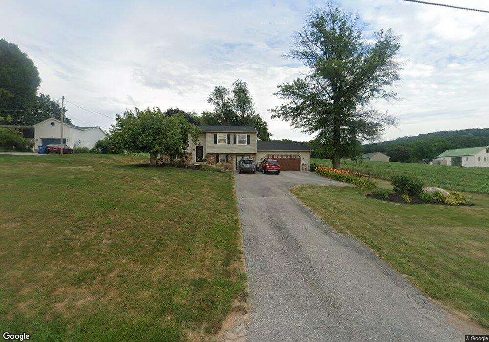
2423 Stoverstown Rd Spring Grove, PA 17362
Estimated Value: $295,371 - $374,000
3
Beds
1
Bath
1,508
Sq Ft
$218/Sq Ft
Est. Value
About This Home
This home is located at 2423 Stoverstown Rd, Spring Grove, PA 17362 and is currently estimated at $328,343, approximately $217 per square foot. 2423 Stoverstown Rd is a home located in York County with nearby schools including Spring Grove Area Middle School, Spring Grove Area High School, and Garbers Mennonite School.
Ownership History
Date
Name
Owned For
Owner Type
Purchase Details
Closed on
Dec 6, 2002
Sold by
Brown Robert H and Brown Rebecca J
Bought by
Marquette Richard W and Marquette Joy C
Current Estimated Value
Home Financials for this Owner
Home Financials are based on the most recent Mortgage that was taken out on this home.
Original Mortgage
$113,600
Outstanding Balance
$49,147
Interest Rate
6.34%
Mortgage Type
Purchase Money Mortgage
Estimated Equity
$279,196
Purchase Details
Closed on
Sep 10, 1990
Bought by
Brown Robert H
Create a Home Valuation Report for This Property
The Home Valuation Report is an in-depth analysis detailing your home's value as well as a comparison with similar homes in the area
Home Values in the Area
Average Home Value in this Area
Purchase History
| Date | Buyer | Sale Price | Title Company |
|---|---|---|---|
| Marquette Richard W | $142,000 | -- | |
| Brown Robert H | $86,500 | -- |
Source: Public Records
Mortgage History
| Date | Status | Borrower | Loan Amount |
|---|---|---|---|
| Open | Marquette Richard W | $113,600 | |
| Closed | Marquette Richard W | $10,000 |
Source: Public Records
Tax History
| Year | Tax Paid | Tax Assessment Tax Assessment Total Assessment is a certain percentage of the fair market value that is determined by local assessors to be the total taxable value of land and additions on the property. | Land | Improvement |
|---|---|---|---|---|
| 2025 | $4,853 | $145,490 | $35,700 | $109,790 |
| 2024 | $4,800 | $145,490 | $35,700 | $109,790 |
| 2023 | $4,800 | $145,490 | $35,700 | $109,790 |
| 2022 | $4,800 | $145,490 | $35,700 | $109,790 |
| 2021 | $4,593 | $145,490 | $35,700 | $109,790 |
| 2020 | $4,593 | $145,490 | $35,700 | $109,790 |
| 2019 | $4,560 | $145,490 | $35,700 | $109,790 |
| 2018 | $4,500 | $145,490 | $35,700 | $109,790 |
| 2017 | $4,397 | $145,490 | $35,700 | $109,790 |
| 2016 | $0 | $145,490 | $35,700 | $109,790 |
| 2015 | -- | $145,490 | $35,700 | $109,790 |
| 2014 | -- | $145,490 | $35,700 | $109,790 |
Source: Public Records
Map
Nearby Homes
- 4815 Zeiglers Church Rd
- 1982 Whyte Ln
- 4861 Zeiglers Church Rd
- 4792 Zeiglers Church Rd
- 5493 Lehman Rd
- 4440 Beards School Rd
- 1885 Stoverstown Rd Unit 9
- 2071 Paperback Way
- 6 N Water St
- 2060 Paperback Way
- 2025 Paperback Way
- 2015 Paperback Way
- 2009 Paperback Way
- 3892 Cannon Ct Unit 3892
- 2005 Paperback Way
- 2016 Paperback Way
- 2012 Paperback Way
- 2010 Paperback Way
- 2008 Paperback Way
- 2004 Paperback Way
- 2417 Stoverstown Rd
- 2409 Stoverstown Rd
- 2397 Stoverstown Rd
- 2389 Stoverstown Rd
- 2383 Stoverstown Rd
- 2382 Stoverstown Rd
- 4904 Bentz Rd
- 2375 Stoverstown Rd
- 4896 Bentz Rd
- 2469 Stoverstown Rd
- 4936 Bentz Rd
- 4864 Bentz Rd
- 2471 Stoverstown Rd
- 4856 Bentz Rd
- 4871 Bentz Rd
- 4861 Bentz Rd
- 4969 Bentz Rd
- 4850 Bentz Rd
- 4855 Bentz Rd
- 4844 Bentz Rd
Your Personal Tour Guide
Ask me questions while you tour the home.