Estimated Value: $213,000 - $235,000
3
Beds
2
Baths
1,332
Sq Ft
$166/Sq Ft
Est. Value
About This Home
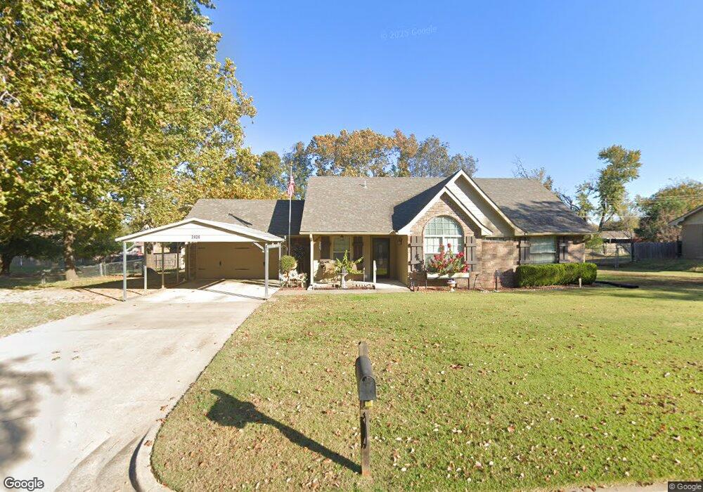
This home is located at 2424 Mayfair Dr, Ada, OK 74820 and is currently estimated at $221,461, approximately $166 per square foot. 2424 Mayfair Dr is a home located in Pontotoc County with nearby schools including ADA Early Childhood Center, Hayes Elementary School, and Washington Elementary School.
Ownership History
Date
Name
Owned For
Owner Type
Purchase Details
Closed on
Dec 6, 2011
Sold by
Lee Jackie Kent and Lee Kathy D
Bought by
Compton Melvin G and Compton Melba F
Current Estimated Value
Purchase Details
Closed on
Aug 18, 2011
Sold by
Matlock Doug and Matlock Courtney
Bought by
Lee Jackie Kent and Lee Kathy D
Home Financials for this Owner
Home Financials are based on the most recent Mortgage that was taken out on this home.
Original Mortgage
$108,800
Interest Rate
4.53%
Mortgage Type
Commercial
Create a Home Valuation Report for This Property
The Home Valuation Report is an in-depth analysis detailing your home's value as well as a comparison with similar homes in the area
Home Values in the Area
Average Home Value in this Area
Purchase History
| Date | Buyer | Sale Price | Title Company |
|---|---|---|---|
| Compton Melvin G | $150,000 | None Available | |
| Lee Jackie Kent | $136,000 | None Available |
Source: Public Records
Mortgage History
| Date | Status | Borrower | Loan Amount |
|---|---|---|---|
| Previous Owner | Lee Jackie Kent | $108,800 |
Source: Public Records
Tax History Compared to Growth
Tax History
| Year | Tax Paid | Tax Assessment Tax Assessment Total Assessment is a certain percentage of the fair market value that is determined by local assessors to be the total taxable value of land and additions on the property. | Land | Improvement |
|---|---|---|---|---|
| 2025 | -- | $24,034 | $2,277 | $21,757 |
| 2024 | -- | $23,335 | $2,211 | $21,124 |
| 2023 | $0 | $22,655 | $2,100 | $20,555 |
| 2022 | $0 | $22,117 | $2,100 | $20,017 |
| 2021 | $0 | $21,687 | $2,100 | $19,587 |
| 2020 | $0 | $21,055 | $2,100 | $18,955 |
| 2019 | $1,926 | $20,052 | $2,100 | $17,952 |
| 2018 | $0 | $20,052 | $2,100 | $17,952 |
| 2017 | $0 | $20,007 | $2,100 | $17,907 |
| 2016 | $1,583 | $19,294 | $1,710 | $17,584 |
| 2015 | $1,614 | $18,375 | $1,800 | $16,575 |
| 2014 | -- | $17,500 | $1,800 | $15,700 |
Source: Public Records
Map
Nearby Homes
- 0 Arlington Blvd
- 2408 Arlington Blvd
- 2000 Woodland Dr
- 106 S Monroe St
- 2507 Kirby Dr
- 112 N Hillcrest St
- 2431 Foliage Dr
- 1928 Arlington St
- 2123 E 12th St
- 825 N Summer Tree Dr
- 1930 Arlington St
- 531 N Crownpoint Dr
- 1914 E Arlington St
- 0 Arlington Hwy Unit 2546045
- 0 Arlington Hwy Unit 2507640
- 0 Arlington Hwy Unit 2535740
- 1902 E 11th St
- 1319 N Wolfe Ln
- 2819 Abbey Dr
- 1100 Emily Ln
- 2430 Mayfair Dr
- 2401 Stephanie Cir
- 2411 Stephanie Cir
- 2331 Stephanie Cir
- 2300 Mayfair Dr
- 2421 Stephanie Cir
- 2411 Mayfair Dr
- 2323 Stephanie Cir
- 2331 Mayfair Dr
- 2429 Stephanie Cir
- 2500 Mayfair Dr
- 2431 Mayfair Dr
- 2501 Stephanie Cir
- 2315 Stephanie Cir
- 2315 Mayfair Dr
- 2400 Stephanie Cir
- 2410 Stephanie Cir
- 2228 Mayfair Dr
- 2424 Stephanie Cir
- 2330 Stephanie Cir