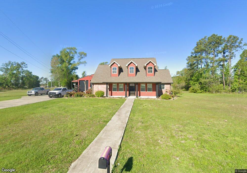
2425 Bertrand Ln Westlake, LA 70669
Estimated Value: $220,000 - $331,000
5
Beds
4
Baths
2,397
Sq Ft
$109/Sq Ft
Est. Value
About This Home
This home is located at 2425 Bertrand Ln, Westlake, LA 70669 and is currently estimated at $261,000, approximately $108 per square foot. 2425 Bertrand Ln is a home located in Calcasieu Parish with nearby schools including Westwood Elementary School, Western Heights Elementary School, and S.P. Arnett Middle School.
Ownership History
Date
Name
Owned For
Owner Type
Purchase Details
Closed on
Oct 11, 2013
Sold by
Pickle Karl Wayne and Pickle Michelle Lynn
Bought by
Todd O Quain Shannon and Quain Chalette Michelle O
Current Estimated Value
Purchase Details
Closed on
Oct 26, 2012
Sold by
Armentor Michael and Armentor Elisa Anne Dalrymple
Bought by
Pickle Karl Wayne and Pickle Michelle Lynn
Home Financials for this Owner
Home Financials are based on the most recent Mortgage that was taken out on this home.
Original Mortgage
$220,500
Interest Rate
3.59%
Mortgage Type
New Conventional
Create a Home Valuation Report for This Property
The Home Valuation Report is an in-depth analysis detailing your home's value as well as a comparison with similar homes in the area
Home Values in the Area
Average Home Value in this Area
Purchase History
| Date | Buyer | Sale Price | Title Company |
|---|---|---|---|
| Todd O Quain Shannon | $254,000 | Lake Charles Title Co Llc | |
| Pickle Karl Wayne | $245,000 | None Available |
Source: Public Records
Mortgage History
| Date | Status | Borrower | Loan Amount |
|---|---|---|---|
| Previous Owner | Pickle Karl Wayne | $220,500 |
Source: Public Records
Tax History Compared to Growth
Tax History
| Year | Tax Paid | Tax Assessment Tax Assessment Total Assessment is a certain percentage of the fair market value that is determined by local assessors to be the total taxable value of land and additions on the property. | Land | Improvement |
|---|---|---|---|---|
| 2024 | $2,870 | $29,750 | $3,800 | $25,950 |
| 2023 | $2,870 | $29,750 | $3,800 | $25,950 |
| 2022 | $2,926 | $29,750 | $3,800 | $25,950 |
| 2021 | $2,145 | $29,750 | $3,800 | $25,950 |
| 2020 | $3,264 | $27,010 | $3,650 | $23,360 |
| 2019 | $3,586 | $28,250 | $2,300 | $25,950 |
| 2018 | $2,641 | $28,250 | $2,300 | $25,950 |
| 2017 | $3,483 | $28,250 | $2,300 | $25,950 |
| 2016 | $2,797 | $28,250 | $2,300 | $25,950 |
| 2015 | $2,797 | $28,250 | $2,300 | $25,950 |
Source: Public Records
Map
Nearby Homes
- 931 John Stine Rd
- 0 John Stine Rd Unit SWL25000871
- 2132 Linda Dr
- 2131 Linda Dr
- 2225 Ellis Dr
- 2203 Ellis Dr
- 1653 Reserve Dr
- 1647 Reserve Dr
- 1733 Myrtle St
- 0 Bobby Jones Way
- 2210 Mccloud St
- 1728 Myrtle St
- 2124 Myrtle Springs Rd
- 1913 Augusta Way
- 0 Augusta Way
- 2215 Pitre St
- 1630 Reserve Dr
- 920 Shady Ln
- 1622 Reserve Dr
- 0 Bee Tree St Unit SWL25000986
- 0 Bertrand Rd
- 1205 John Stine Rd
- 2411 Bertrand Ln
- 1236 John Stine Rd
- 1222 John Stine Rd
- 0 tbd John Stine Rd
- 1204 Katy Dr
- 1204 Katy Ln
- 1208 Katy Dr
- 1208 Katy Ln
- 1214 John Stine Rd
- 1210 Katy Ln
- 1709 John Stine Rd
- 1725 John Stine Rd
- 1216 Katy Ln
- 2312 Ben Franklin Dr
- 1220 Katy Dr
- 1220 Katy Ln
- 0 John Stine Rd
- 1201 Katy Ln