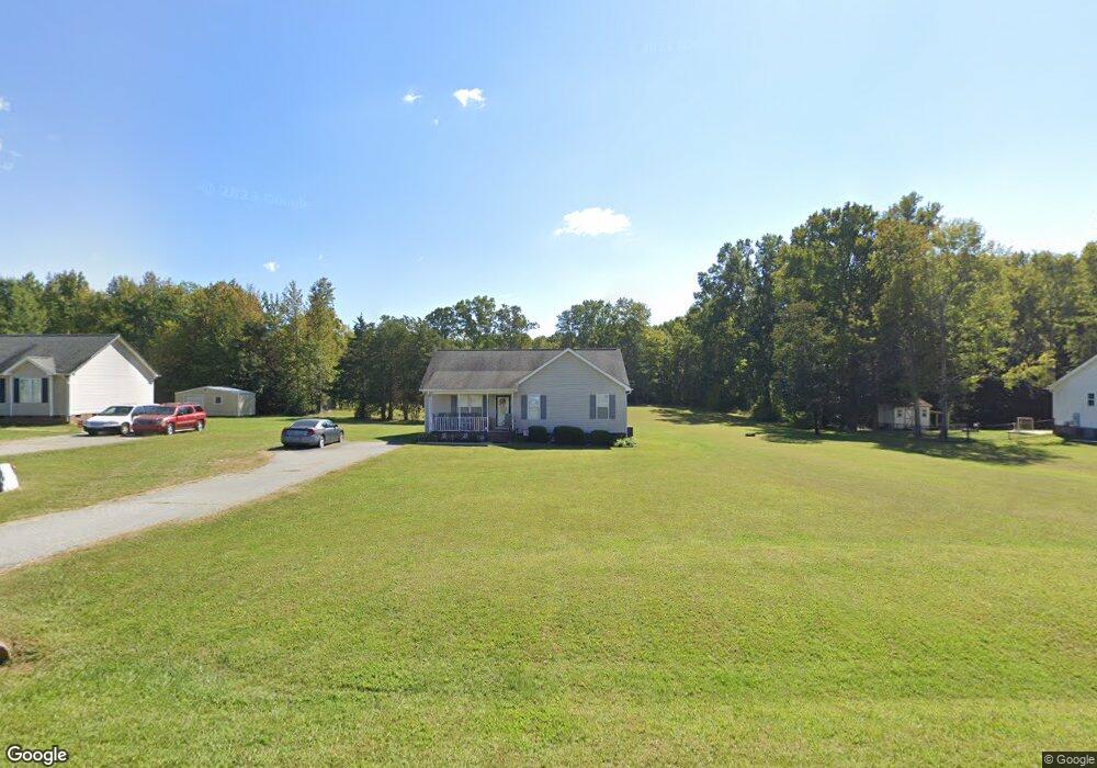
2427 Foxfire Ln Burlington, NC 27217
Estimated Value: $275,229 - $310,000
3
Beds
2
Baths
1,266
Sq Ft
$231/Sq Ft
Est. Value
About This Home
This home is located at 2427 Foxfire Ln, Burlington, NC 27217 and is currently estimated at $292,807, approximately $231 per square foot. 2427 Foxfire Ln is a home located in Alamance County with nearby schools including Pleasant Grove Elementary School, Woodlawn Middle School, and Eastern Alamance High School.
Ownership History
Date
Name
Owned For
Owner Type
Purchase Details
Closed on
Aug 23, 2006
Sold by
Marlow Lester M
Bought by
Royster Diane
Current Estimated Value
Home Financials for this Owner
Home Financials are based on the most recent Mortgage that was taken out on this home.
Original Mortgage
$125,000
Outstanding Balance
$74,680
Interest Rate
6.67%
Mortgage Type
New Conventional
Estimated Equity
$218,127
Purchase Details
Closed on
Sep 20, 2005
Sold by
Grada Investments
Bought by
Marlow Lester M
Home Financials for this Owner
Home Financials are based on the most recent Mortgage that was taken out on this home.
Original Mortgage
$115,900
Interest Rate
5.86%
Mortgage Type
New Conventional
Create a Home Valuation Report for This Property
The Home Valuation Report is an in-depth analysis detailing your home's value as well as a comparison with similar homes in the area
Purchase History
| Date | Buyer | Sale Price | Title Company |
|---|---|---|---|
| Royster Diane | $125,000 | -- | |
| Marlow Lester M | $122,000 | -- |
Source: Public Records
Mortgage History
| Date | Status | Borrower | Loan Amount |
|---|---|---|---|
| Open | Royster Diane | $125,000 | |
| Previous Owner | Marlow Lester M | $115,900 |
Source: Public Records
Tax History
| Year | Tax Paid | Tax Assessment Tax Assessment Total Assessment is a certain percentage of the fair market value that is determined by local assessors to be the total taxable value of land and additions on the property. | Land | Improvement |
|---|---|---|---|---|
| 2025 | $1,549 | $260,739 | $31,547 | $229,192 |
| 2024 | $1,439 | $260,739 | $31,547 | $229,192 |
| 2023 | $1,336 | $260,739 | $31,547 | $229,192 |
| 2022 | $1,021 | $133,250 | $30,045 | $103,205 |
| 2021 | $1,008 | $133,250 | $30,045 | $103,205 |
| 2020 | $1,021 | $133,250 | $30,045 | $103,205 |
| 2019 | $1,026 | $133,250 | $30,045 | $103,205 |
| 2018 | $0 | $133,250 | $30,045 | $103,205 |
| 2017 | $902 | $133,250 | $30,045 | $103,205 |
| 2016 | $981 | $144,281 | $30,045 | $114,236 |
| 2015 | $947 | $144,281 | $30,045 | $114,236 |
| 2014 | $876 | $144,281 | $30,045 | $114,236 |
Source: Public Records
Map
Nearby Homes
- 2208 Foxfire Ln
- 3521 N Carolina 49
- 3521 N Nc Highway 49
- 3549 N Nc Highway 49
- 2513 William Allen Rd
- 0 Pack Ln
- 2858 John Lewis Rd
- 0 Barnett Rd Unit 10148309
- 3082 Cascade Dr
- 2200 State Highway 49
- 3549 N Carolina 49 Hwy
- 0 Haith Fuller Trail
- 134 Pillow Ln
- 211 Sumter Ct
- 284 Donelson Way
- 1420 Mccray Rd
- 7411 N Carolina 62
- 3610 Barnett Rd
- 00 Haith Fuller Trail
- 1800 State Highway 49
- 2437 Foxfire Ln
- 2407 Foxfire Ln
- 2447 Foxfire Ln
- 2424 Foxfire Ln
- 2436 Foxfire Ln
- 2414 Foxfire Ln
- 2457 Foxfire Ln
- 2395 Foxfire Ln
- 2446 Foxfire Ln
- L17 Foxfire Ln
- L12 Foxfire Ln
- L13 Foxfire Ln
- L14 Foxfire Ln
- L6 Foxfire Ln
- L29 Foxfire Ln
- L16 Foxfire Ln
- L15 Foxfire Ln
- L31 Foxfire Ln
- L4 Foxfire Ln
- 110 Foxfire Ln
Your Personal Tour Guide
Ask me questions while you tour the home.