Estimated Value: $441,494 - $505,000
4
Beds
3
Baths
2,692
Sq Ft
$174/Sq Ft
Est. Value
About This Home
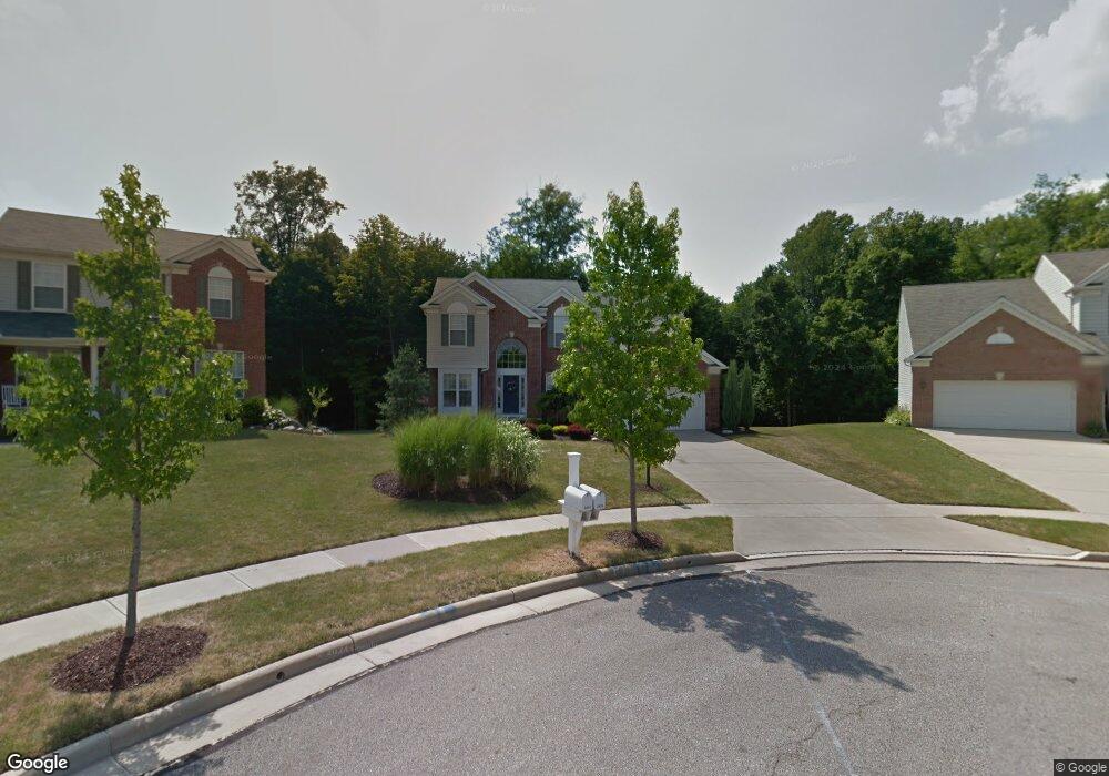
This home is located at 2429 Harvester Dr, Stow, OH 44224 and is currently estimated at $469,624, approximately $174 per square foot. 2429 Harvester Dr is a home located in Summit County with nearby schools including Stow-Munroe Falls High School, Primrose School of Hudson, and Holy Family Elementary School.
Ownership History
Date
Name
Owned For
Owner Type
Purchase Details
Closed on
Jun 10, 2005
Sold by
Pulte Homes Of Ohio Llc
Bought by
Andrews Mark E and Andrews Lisa A
Current Estimated Value
Home Financials for this Owner
Home Financials are based on the most recent Mortgage that was taken out on this home.
Original Mortgage
$179,090
Interest Rate
6.48%
Mortgage Type
Fannie Mae Freddie Mac
Create a Home Valuation Report for This Property
The Home Valuation Report is an in-depth analysis detailing your home's value as well as a comparison with similar homes in the area
Home Values in the Area
Average Home Value in this Area
Purchase History
| Date | Buyer | Sale Price | Title Company |
|---|---|---|---|
| Andrews Mark E | $309,120 | Pulte Title Agency Llc |
Source: Public Records
Mortgage History
| Date | Status | Borrower | Loan Amount |
|---|---|---|---|
| Previous Owner | Andrews Mark E | $179,090 |
Source: Public Records
Tax History Compared to Growth
Tax History
| Year | Tax Paid | Tax Assessment Tax Assessment Total Assessment is a certain percentage of the fair market value that is determined by local assessors to be the total taxable value of land and additions on the property. | Land | Improvement |
|---|---|---|---|---|
| 2025 | $9,918 | $128,065 | $23,324 | $104,741 |
| 2024 | $9,918 | $128,065 | $23,324 | $104,741 |
| 2023 | $9,918 | $128,065 | $23,324 | $104,741 |
| 2022 | $10,179 | $105,840 | $19,278 | $86,562 |
| 2021 | $9,274 | $105,840 | $19,278 | $86,562 |
| 2020 | $7,963 | $105,840 | $19,280 | $86,560 |
| 2019 | $7,825 | $103,370 | $18,890 | $84,480 |
| 2018 | $7,534 | $103,370 | $18,890 | $84,480 |
| 2017 | $6,251 | $103,370 | $18,890 | $84,480 |
| 2016 | $6,036 | $94,080 | $18,890 | $75,190 |
| 2015 | $6,251 | $94,080 | $18,890 | $75,190 |
| 2014 | $5,699 | $94,080 | $18,890 | $75,190 |
| 2013 | $5,550 | $92,190 | $18,890 | $73,300 |
Source: Public Records
Map
Nearby Homes
- 2327 Crockett Cir
- 5114 Bayside Lake Blvd
- 1884 Village Ct Unit X66
- 4630 Red Willow Rd
- V/L Norton Rd
- 1938 Higby Dr
- 2380 Port Williams Dr Unit 2380
- 5217 Beckett Ridge
- 0 Stow Rd Unit 5102979
- 1664 Cypress Ct
- 1668 Cypress Ct
- 2017 Kingsdale Dr
- 1525 Spruce Hill Dr
- 1808 Higby Dr Unit A
- 4877 Cedar Crest Ln
- 4891 Cedar Crest Ln
- 2410 Wrens Dr S
- 4944 Friar Rd Unit D
- 2028 Crestdale Dr
- 1620 Sapphire Dr
- 2449 Harvester Dr
- 2419 Harvester Dr
- 2399 Harvester Dr
- 2469 Harvester Dr
- 2466 Harvester Dr
- 2389 Harvester Dr
- 2426 Harvester Dr
- 2446 Harvester Dr
- 2406 Harvester Dr
- 4838 Concord Dr
- 4853 Concord Dr
- 2388 Harvester Dr
- 4846 Concord Dr
- 4946 Stow Rd
- 2369 Harvester Dr
- 2353 Harvester Dr
- 4861 Concord Dr
- 4852 Concord Dr
- 2345 Harvester Dr
- 2361 Harvester Dr